Tập tin:Map Denmark Demis SE islands.gif
Không có độ phân giải cao hơn.
Map_Denmark_Demis_SE_islands.gif (415×420 điểm ảnh, kích thước tập tin: 23 kB, kiểu MIME: image/gif)
Tập tin này từ Wikimedia Commons. Trang miêu tả nó ở đấy được sao chép dưới đây. Commons là kho lưu trữ tập tin phương tiện có giấy phép tự do. Bạn có thể tham gia. |
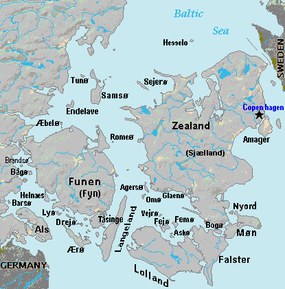
Miêu tả
| Miêu tả | Terrain map of southeast Denmark, showing the major islands labeled, in the region between Germany and Sweden. The terrain data was extracted from the Demis map (on Wikimedia Commons) Image:La2-demis-denmark.png, and the extracted map was color-shifted to grayshade land areas (from the green Demis map). Labels are in font face Arial or Arial Narrow, sizes 8-10. |
| Ngày | |
| Nguồn gốc | Derivative of Demis map: Image:La2-demis-denmark.png |
| Tác giả | Wikid77 (derivative of Demis map) |
Giấy phép
This image is in the public domain because it came from the site https://www.demis.nl/products/web-map-server/examples/ and was released by the copyright holder. Permission is granted to copy, distribute and/or modify this map since it is based on free of copyright images from: www.demis.nl. See also approval email on de.wp and its clarification.
|
| This work has been released into the public domain by its copyright holder, www.demis.nl. This applies worldwide. Tại một quốc gia mà luật pháp không cho phép điều này, thì: www.demis.nl cho phép tất cả mọi người được quyền sử dụng tác phẩm này với bất cứ mục đích nào, không kèm theo bất kỳ điều kiện nào, trừ phi luật pháp yêu cầu những điều kiện đó.
|
Lịch sử tập tin
Nhấn vào ngày/giờ để xem nội dung tập tin tại thời điểm đó.
| Ngày/giờ | Hình xem trước | Kích cỡ | Thành viên | Miêu tả | |
|---|---|---|---|---|---|
| hiện tại | 18:51, ngày 3 tháng 9 năm 2007 | | 415×420 (23 kB) | Wikid77 | added 14 island names |
| 10:50, ngày 2 tháng 9 năm 2007 |  | 415×420 (22 kB) | Wikid77 | added "Sejero" + "Amager" | |
| 12:56, ngày 1 tháng 9 năm 2007 |  | 415×420 (22 kB) | Wikid77 | cut height 10px for square/undistorted resizing; cut banner "DENMARK" to appear in banner version | |
| 12:46, ngày 1 tháng 9 năm 2007 |  | 415×430 (22 kB) | Wikid77 | cut map width 10px as 415px magnified 3%; banner "DENMARK"; enlarged names; darkened Germany/Sweden | |
| 13:36, ngày 31 tháng 8 năm 2007 |  | 425×430 (22 kB) | Wikid77 | Terrain map of southeast Denmark, showing the major islands labeled, in the region between Germany and Sweden. The terrain data was extracted from the Demis map (on Wikimedia Commons) Image:La2-demis-denmark.png , and the extracted map w |
Trang sử dụng tập tin
Có 9 trang tại Wikipedia tiếng Việt có liên kết đến tập tin (không hiển thị trang ở các dự án khác):
Sử dụng tập tin toàn cục
Những wiki sau đang sử dụng tập tin này:
- Trang sử dụng tại da.wikipedia.org
- Trang sử dụng tại el.wikipedia.org
- Trang sử dụng tại en.wikipedia.org
- Trang sử dụng tại es.wikipedia.org
- Trang sử dụng tại fi.wikipedia.org
- Trang sử dụng tại fr.wikipedia.org
- Trang sử dụng tại gl.wikipedia.org
- Trang sử dụng tại hr.wikipedia.org
- Trang sử dụng tại it.wikipedia.org
- Trang sử dụng tại ka.wikipedia.org
- Trang sử dụng tại la.wikipedia.org
- Trang sử dụng tại lt.wikipedia.org
- Trang sử dụng tại pt.wikipedia.org
- Trang sử dụng tại sl.wikipedia.org
- Trang sử dụng tại zh.wikipedia.org