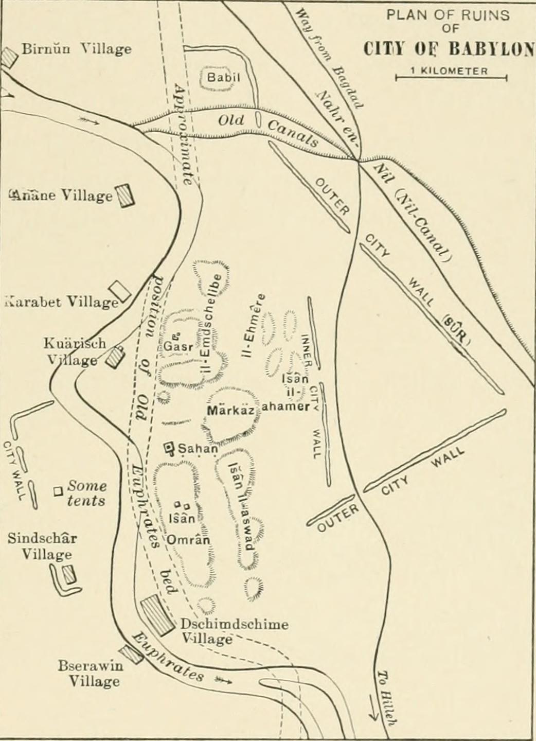
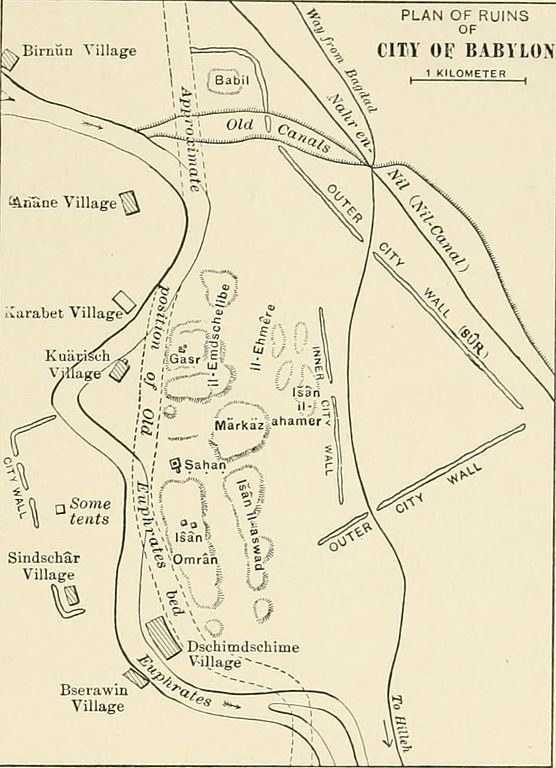
Tập tin:Plan of Ruins of Babylon 1905.jpg
Tập tin gốc (1.042×1.440 điểm ảnh, kích thước tập tin: 137 kB, kiểu MIME: image/jpeg)
Tập tin này từ Wikimedia Commons. Trang miêu tả nó ở đấy được sao chép dưới đây. Commons là kho lưu trữ tập tin phương tiện có giấy phép tự do. Bạn có thể tham gia. |
Miêu tả
| Miêu tả |
Identifier: historyofallnati02wrig Title: A history of all nations from the earliest times; being a universal historical library Year: 1905 (1900s) Authors: Wright, John Henry, 1852-1908 Subjects: World history Publisher: [Philadelphia, New York : Lea Brothers & company Contributing Library: University of California Libraries Digitizing Sponsor: Internet Archive
Click here to view book online to see this illustration in context in a browseable online version of this book.
Text Appearing After Image: Fio. 28. — Plan of the Ruins of Babylon.[From Weisshac/i, die Stadt Buhylim (Leipzig, 1904).] corner is still extant. Herodotus, who tells us that he visited Baby-lon, gives as the circumference of the outmost wall (which alreadyin his day had been in places destroyed by the Persians) 480 stadia,or a little over bo miles, stating that it had 250 towers and 100gates of bronze (cased with bronze). The diagonal formed by theEuphrates — if treated as a straight line, 170 stadia or nearly 20miles in length — divided the square into two triangles, in one ofwhich stood the royal city; in the other, within a sacred precinct of Vol. II.—9 130 ^l*>^^^ AFTER THE FALL OF ASSYRIA. one-quarter of a mile in circumference, a temple of eight towers(stages), surrounded by a spiral ramp, and containing the shrine andimage of Marduk. The triaugles were connected by a wooden bridgeon stone piers. Ctesias, the only extant Greek author besides He-rodotus who saw ancient Babylon, gives the circumf
|
| Nguồn gốc | Image from page 148 of "A history of all nations from the earliest times; being a universal historical library" (1905) |
| Tác giả | Internet Archive Book Images |
| Giấy phép (Dùng lại tập tin) |
Internet Archive Book Images @ Flickr Commons |
Giấy phép
Hình ảnh này được lấy từ The Commons của Flickr. Tổ chức tải lên có thể có nhiều lý do khác nhau để xác định rằng không có giới hạn bản quyền tồn tại, chẳng hạn như:
Bạn có thể xem thêm thông tin về "The Commons" của Flickr tại https://flickr.com/commons/usage/. Xin hãy bổ sung thêm thẻ quyền (tuỳ chọn) vào hình ảnh này nếu có thể xác định được thông tin cụ thể hơn về tình trạng bản quyền. Xem Commons:Giấy phép để biết thêm thông tin. |
| Hình này ban đầu được tải lên Flickr bởi Internet Archive Book Images tại https://www.flickr.com/photos/126377022@N07/14759211776. Tập tin đã được FlickreviewR kiểm tra vào 2015-03-15 20:50:32 và xác nhận rằng nó tuân theo các điều khoản của No known copyright restrictions, phù hợp với quy định của Commons. Tuy nhiên, đó không phải là giấy phép giống như đã nêu ở trên, và không xác định được liệu giấy phép đó có hiệu lực hay không. |
Lịch sử tập tin
Nhấn vào ngày/giờ để xem nội dung tập tin tại thời điểm đó.
| Ngày/giờ | Hình xem trước | Kích cỡ | Thành viên | Miêu tả | |
|---|---|---|---|---|---|
| hiện tại | 20:12, ngày 15 tháng 3 năm 2015 | | 1.042×1.440 (137 kB) | Nizil Shah | Transferred from Flickr via Flickr2Commons |
Trang sử dụng tập tin
Sử dụng tập tin toàn cục
Những wiki sau đang sử dụng tập tin này:
- Trang sử dụng tại ca.wikipedia.org
- Trang sử dụng tại en.wikipedia.org
- Trang sử dụng tại ja.wikipedia.org
- Trang sử dụng tại mt.wikipedia.org