Tập tin:Special member state territories and the European Union.svg

Kích thước bản xem trước PNG này của tập tin SVG: 512×258 điểm ảnh. Độ phân giải khác: 320×161 điểm ảnh | 640×323 điểm ảnh | 1.024×516 điểm ảnh | 1.280×645 điểm ảnh | 2.560×1.290 điểm ảnh.
Tập tin gốc (tập tin SVG, 512×258 điểm ảnh trên danh nghĩa, kích thước: 835 kB)
Tập tin này từ Wikimedia Commons. Trang miêu tả nó ở đấy được sao chép dưới đây. Commons là kho lưu trữ tập tin phương tiện có giấy phép tự do. Bạn có thể tham gia. |
Miêu tả
| Miêu tả |
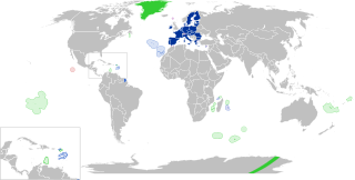
English:
European Union
Outermost regions
Overseas countries and territories
Special cases
Other special territories Français : Union européenne
Régions ultrapériphériques
Pays et territoires d'outre-mer
Cas spéciaux
Autres territoires spéciaux |
| Ngày | |
| Nguồn gốc | Tác phẩm được tạo bởi người tải lên |
| Tác giả | Glentamara |
| SVG genesis |
Giấy phép
| Tôi, người giữ bản quyền của tác phẩm này, chuyển tác phẩm này vào phạm vi công cộng. Điều này có giá trị trên toàn thế giới. Tại một quốc gia mà luật pháp không cho phép điều này, thì: Tôi cho phép tất cả mọi người được quyền sử dụng tác phẩm này với bất cứ mục đích nào, không kèm theo bất kỳ điều kiện nào, trừ phi luật pháp yêu cầu những điều kiện đó. |
Lịch sử tập tin
Nhấn vào ngày/giờ để xem nội dung tập tin tại thời điểm đó.
| Ngày/giờ | Hình xem trước | Kích cỡ | Thành viên | Miêu tả | |
|---|---|---|---|---|---|
| hiện tại | 19:12, ngày 8 tháng 6 năm 2022 | | 512×258 (835 kB) | Nablicus | new version |
| 10:13, ngày 17 tháng 7 năm 2020 |  | 512×259 (736 kB) | Alcaios | fixed – those were models I use to check the scale | |
| 23:03, ngày 16 tháng 7 năm 2020 |  | 512×258 (672 kB) | Nablicus | Reverted to version as of 19:08, 16 July 2020 (UTC). There is an extra UK and Iceland in the middle of Canada... | |
| 19:53, ngày 16 tháng 7 năm 2020 |  | 512×259 (753 kB) | Alcaios | frame | |
| 19:50, ngày 16 tháng 7 năm 2020 |  | 512×258 (681 kB) | Alcaios | minor fixed on Greenland mar. zone | |
| 19:46, ngày 16 tháng 7 năm 2020 |  | 512×258 (681 kB) | Alcaios | Added maritime zone of Gree,land based on https://www.marineregions.org/eezdetails.php?mrgid=8438 | |
| 19:32, ngày 16 tháng 7 năm 2020 |  | 512×259 (752 kB) | Alcaios | added Faroe Islands' maritime zone | |
| 19:08, ngày 16 tháng 7 năm 2020 |  | 512×258 (672 kB) | Alcaios | Maritime zones in the eastern Caribbean at the right scale, with the help of https://commons.wikimedia.org/wiki/File:Caribbean_maritime_boundaries_map.svg | |
| 18:44, ngày 16 tháng 7 năm 2020 |  | 512×259 (742 kB) | Alcaios | slight realignments | |
| 18:38, ngày 16 tháng 7 năm 2020 |  | 512×259 (742 kB) | Alcaios | typo in previous edit, read: "Northern Cyprus is not a special member state territory since..." –– the Åland archipelago is larger and almost reaches the Finnish coast |
Trang sử dụng tập tin
Có 1 trang tại Wikipedia tiếng Việt có liên kết đến tập tin (không hiển thị trang ở các dự án khác):
Sử dụng tập tin toàn cục
Những wiki sau đang sử dụng tập tin này:
- Trang sử dụng tại ar.wikipedia.org
- Trang sử dụng tại br.wikipedia.org
- Trang sử dụng tại cs.wikipedia.org
- Trang sử dụng tại de.wikipedia.org
- Trang sử dụng tại en.wikipedia.org
- European Union
- Neocolonialism
- Outline of the European Union
- Special territories of members of the European Economic Area
- Potential enlargement of the European Union
- External border of the European Union
- User:Falcaorib
- User:Xicomaia/sandbox
- User:Spinykitsune65/sandbox2
- User:A diehard editor/sandbox/EU infobox
- Trang sử dụng tại fa.wikipedia.org
- Trang sử dụng tại fr.wikipedia.org
- Aruba
- Ceuta
- Polynésie française
- Groenland
- Açores
- Saint-Pierre-et-Miquelon
- Îles Canaries
- Madère
- Îles Kerguelen
- Île Clipperton
- Îles Féroé
- Région ultrapériphérique
- Îles Éparses de l'océan Indien
- Curaçao
- Åland
- Melilla
- Archipel Crozet
- Terre Adélie
- Bonaire
- Saba
- Saint-Eustache (Antilles)
- Peñón de Vélez de la Gomera
- Peñón de Alhucemas
- Îles Saint-Paul et Amsterdam
- Plazas de soberanía
- Nouvelle-Calédonie
- Saint-Martin (royaume des Pays-Bas)
- Saint-Martin (Antilles françaises)
- Pays et territoire d'outre-mer
- Saint-Barthélemy (Antilles françaises)
- Union européenne
- États membres de l'Union européenne
- Terres australes et antarctiques françaises
Xem thêm các trang toàn cục sử dụng tập tin này.