Tập tin:10May 16May Battle of Belgium.PNG

Kích thước hình xem trước: 775×599 điểm ảnh. Độ phân giải khác: 311×240 điểm ảnh | 621×480 điểm ảnh | 891×689 điểm ảnh.
Tập tin gốc (891×689 điểm ảnh, kích thước tập tin: 156 kB, kiểu MIME: image/png)
Tập tin này từ Wikimedia Commons. Trang miêu tả nó ở đấy được sao chép dưới đây. Commons là kho lưu trữ tập tin phương tiện có giấy phép tự do. Bạn có thể tham gia. |
| Miêu tả |
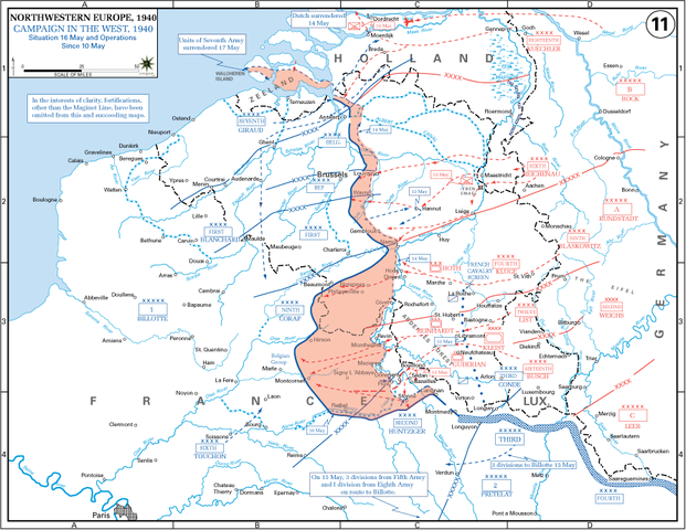
English: The German advance between 10 May and 16 May 1940. The red area denotes the territory captured by Germany during this time. The German field armies and Corps are shown in red. The red plan icon indicates the German airborne attack on the Belgian fortress of Eben-Emael. The operating area of the various Belgian, British, and French field armies and Army groups are shown in blue. The checkered white and blue area denotes the French Maginot Line. The commanders of the various units are shown under their respective formation. Solid lines represent the boundaries between each major unit. Dotted lines depict lines of advance. Key dates are shown in boxes. |
| Ngày | (UTC) |
| Nguồn gốc |
(Original text: http://www.dean.usma.edu/history/web03/atlases/ww2%20europe/EuropeanTheaterGIF/WWIIEurope11.gif) Archive link to original website used for the map and the archive link to the map source page. Current link to map, and link to map source page. |
| Tác giả | The History Department of the United States Military Academy |
| Phiên bản khác | File:10May-16May1940-Fall Gelb.jpg |
Giấy phép
Hình ảnh này là tác phẩm của binh sĩ hoặc nhân viên của Lục quân Hoa Kỳ, được chụp hoặc tạo ra khi đang làm nhiệm vụ. Là một tác phẩm của chính quyền liên bang Hoa Kỳ, hình ảnh hoặc tập tin này thuộc về phạm vi công cộng.
|
 |
Nhật trình tải lên đầu tiên
Chuyển từ en.wikipedia sang Commons by Piotrus using CommonsHelper.
Trang miêu tả gốc từng tồn tại ở đây. Tất cả các tên người dùng sau là tên người dùng tại en.wikipedia.
- 2009-11-08 19:43 Coldplay Expert 891×689× (159258 bytes) {{Information |Description = The German advance until noon, 16 May 1940. The map also reveals the dispositions of the Belgian Army and its allies. |Source = http://www.dean.usma.edu/history/web03/atlases/ww2%20europe/EuropeanTheaterGIF/WWIIEu
Lịch sử tập tin
Nhấn vào ngày/giờ để xem nội dung tập tin tại thời điểm đó.
| Ngày/giờ | Hình xem trước | Kích cỡ | Thành viên | Miêu tả | |
|---|---|---|---|---|---|
| hiện tại | 18:35, ngày 17 tháng 3 năm 2010 | | 891×689 (156 kB) | File Upload Bot (Magnus Manske) | {{BotMoveToCommons|en.wikipedia|year={{subst:CURRENTYEAR}}|month={{subst:CURRENTMONTHNAME}}|day={{subst:CURRENTDAY}}}} {{Information |Description={{en|The German advance until noon, 16 May 1940. The map also reveals the dispositions of the Belgian Army a |
Trang sử dụng tập tin
Có 1 trang tại Wikipedia tiếng Việt có liên kết đến tập tin (không hiển thị trang ở các dự án khác):
Sử dụng tập tin toàn cục
Những wiki sau đang sử dụng tập tin này:
- Trang sử dụng tại azb.wikipedia.org
- Trang sử dụng tại ca.wikipedia.org
- Trang sử dụng tại en.wikipedia.org
- Battle of France
- 23rd (Northumbrian) Division
- French war planning 1920–1940
- British Expeditionary Force (World War II)
- 46th Infantry Division (United Kingdom)
- 12th (Eastern) Infantry Division
- Historiography of the Battle of France
- German radio intelligence operations during World War II
- Talk:World War II/Archive 53
- XIX Army Corps
- User:Falcaorib/France
- Trang sử dụng tại es.wikipedia.org
- Trang sử dụng tại fr.wikipedia.org
- Trang sử dụng tại hu.wikipedia.org
- Trang sử dụng tại ko.wikipedia.org
- Trang sử dụng tại ms.wikipedia.org
- Trang sử dụng tại nl.wikipedia.org
- Trang sử dụng tại pl.wikipedia.org
- Trang sử dụng tại ro.wikipedia.org
- Trang sử dụng tại sr.wikipedia.org
- Trang sử dụng tại ta.wikipedia.org
- Trang sử dụng tại th.wikipedia.org
- Trang sử dụng tại uk.wikipedia.org