Tập tin:12nm hypothetical Territorial Sea compared with Northern Limit Line, North Korea.jpg

Tập tin gốc (1.315×938 điểm ảnh, kích thước tập tin: 147 kB, kiểu MIME: image/jpeg)
Tập tin này từ Wikimedia Commons. Trang miêu tả nó ở đấy được sao chép dưới đây. Commons là kho lưu trữ tập tin phương tiện có giấy phép tự do. Bạn có thể tham gia. |
Miêu tả
| Miêu tả |
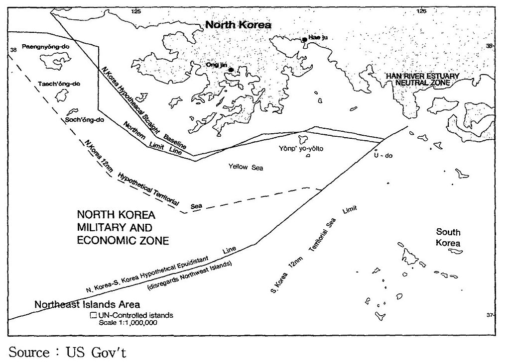
English: A US Government map showing where a North Korean 12 nautical mile Territorial Waters limit would be, when disregarding the north west UN Command islands, compared to the UN Command created Northern Limit Line. |
| Ngày | Không biết ngày |
| Nguồn gốc | http://118.129.184.33/pub/docu/kr/AM/06/AM062001B01/IMAGE/AM06-2001-B01-0210-01.jpg |
| Tác giả | US Government |
| Phiên bản khác |
Derivative works of this file: Yeonpyeong Island live firing range map.png:  |
Map taken from HTML version of the paper, which included this US Government credited map:
Seong-Geol Hong, Sun-Pyo Kim, Hyung-Ki Lee (2001-06-30). "Fisheries Cooperation and Maritime Delimitation Issues between North Korea and Its Neighboring Countries". Ocean Policy Research 16 (1): 191-216. Korea Maritime Institute. Archived from the original on 2011-07-23. Retrieved on 2010-11-28.
HTML version of paper: http://118.129.184.33/pub/docu/kr/AM/06/AM062001B01/AM06-2001-B01-006.HTM[dead link]
According to a Korean Central News Agency article "Northern Limit Line rejected" of 2 August 2002[1] archive copy at the Wayback Machine "the U.S. government distributed [this map] to the participants in the UN conference on maritime law held in the U.S. in 1980". The map is also published in paper by Kim, Jung-Gun (Spring-Summer 1985). "Reflections on the attitude of North Korea toward the Law of the Sea (UNCLOS III Treaty)". Asian Perspective 9 (1)., and John Barry Kotch & Michael Abbey in Asian Perspective, Vol. 27, No. 2, 2003, pp. 175-204 archive copy at the Wayback Machine.
The CIA report "The West Coast Korean Islands", BGI RP 74-9, January 1974 (Declassified 2000-04-18 as CIA-RDP-84-00825R000300120001-7)[2] describes this, or a very similar, map. However the map itself is redacted from the declassified version of the report.
Giấy phép
Công trình này thuộc về phạm vi công cộng tại Hoa Kỳ bởi vì đây là công trình được chuẩn bị bởi một quan chức hoặc nhân viên của Chính phủ Hoa Kỳ như một phần nhiệm vụ chính thức của người đó theo các điều khoản của Title 17, Chương 1, Mục 105 của the Bộ luật Hoa Kỳ.
Chú ý: Điều này chỉ áp dụng cho các tác phẩm gốc của Chính phủ Liên bang và không áp dụng cho tác phẩm của bất kỳ tiểu bang, lãnh thổ, khối thịnh vượng chung, hạt, đô thị hoặc bất kỳ phân khu nào khác của Hoa Kỳ. Bản mẫu này cũng không áp dụng cho các thiết kế tem bưu chính được xuất bản bởi Bưu chính Hoa Kỳ kể từ năm 1978. (Xem § 313.6(C)(1) của Compendium of U.S. Copyright Office Practices). Nó cũng không áp dụng cho một số đồng xu của Hoa Kỳ; xem Điều khoản sử dụng của US Mint.
|
 | |
| Tập tin này đã được đánh dấu là không bị hạn chế dưới luật bản quyền, kể cả tất cả những quyền liên quan và lần cận. | ||
Lịch sử tập tin
Nhấn vào ngày/giờ để xem nội dung tập tin tại thời điểm đó.
| Ngày/giờ | Hình xem trước | Kích cỡ | Thành viên | Miêu tả | |
|---|---|---|---|---|---|
| hiện tại | 23:05, ngày 28 tháng 11 năm 2010 | | 1.315×938 (147 kB) | Rwendland | {{Information |Description={{en|1=A US Government map showing where a North Korean 12 nautical mile Territorial Waters limit would be, when disregarding the north west UN Command islands, compared to the UN Command created Northern Limit Line.}} |Source=h |
Trang sử dụng tập tin
Sử dụng tập tin toàn cục
Những wiki sau đang sử dụng tập tin này:
- Trang sử dụng tại en.wikipedia.org
- Trang sử dụng tại fr.wikipedia.org
- Trang sử dụng tại id.wikipedia.org
- Trang sử dụng tại ko.wikipedia.org
- Trang sử dụng tại no.wikipedia.org
- Trang sử dụng tại ru.wikipedia.org
- Trang sử dụng tại uk.wikipedia.org
- Trang sử dụng tại zh.wikipedia.org