Tập tin:1827 Finley Map of Africa - Geographicus - Africa-finley-1827.jpg
Kích thước hình xem trước: 466×599 điểm ảnh. Độ phân giải khác: 186×240 điểm ảnh | 373×480 điểm ảnh | 597×768 điểm ảnh | 796×1.024 điểm ảnh | 2.332×3.000 điểm ảnh.
Tập tin gốc (2.332×3.000 điểm ảnh, kích thước tập tin: 1,97 MB, kiểu MIME: image/jpeg)
Tập tin này từ Wikimedia Commons. Trang miêu tả nó ở đấy được sao chép dưới đây. Commons là kho lưu trữ tập tin phương tiện có giấy phép tự do. Bạn có thể tham gia. |
| Anthony Finley: Africa.
( |
||||||||||||||
|---|---|---|---|---|---|---|---|---|---|---|---|---|---|---|
| Họa sĩ |
|
|||||||||||||
| Tựa đề |
Africa. |
|||||||||||||
| Miêu tả |
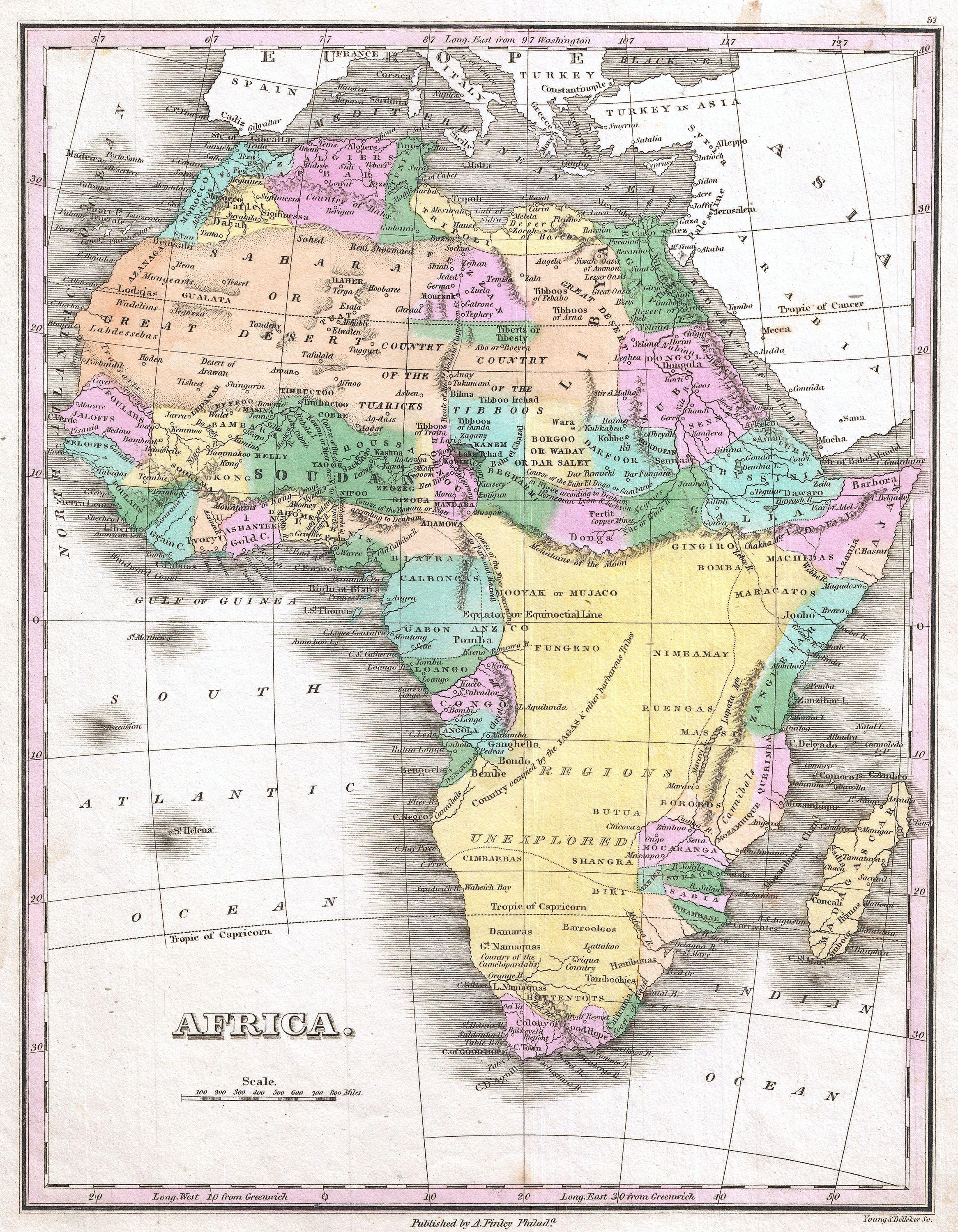
Afrikaans: 'n Pragtige voorbeeld van Anthony Finley se invloedryke kaart van Afrika, wat deur Young en Delleker gegraveer is vir die 1827-uitgawe van Finley se General Atlas. Die titel en skaal is links onder. Hierdie uitsonderlike kaart het die sterk eskalasie in verkenning van Afrika tydens die mid-19de eeu voorafgegaan, en die binneland van Afrika bly hier grotendeels onbekend. Die Ptolemaïese Berge van die Maan word aangedui as 'n bergreeks wat wes na oos oor die sentrale deel van die kontinent strek, met die suggestie dat verskeie takke van die Nyl hier ontspring. Verskeie spekulatiewe lope van die Nigerrivier word aangedui, met een wat by die Nyl aansluit, 'n ander wat suid van die Berge van die Maan die Kongo binnevloei, en nog 'n ander wat korrek getoon word met 'n kromming na 'n monding in die Golf van Bonny / Biafra. Regdeur word etlike etniese groepe aangedui, waaronder die Pomba, Jaga, Timboektoe, Toeareg, Tibboe, Bambara en ander. Ook word 'n land van kannibale in Mosambiek onderskei.
English: A beautiful example of Finley's important 1827 map of Africa. This uncommon map predates the explosion of African exploration that occurred in the mid 19th century. Much of the interior remains unknown. The Ptolemaic Mountains of the Moon are drawn stretching across the central part of the continent with the suggestions that they are the source of several branches of the Nile. Several speculative courses are drawn for the Niger River, one of which joins it to the Nile, another of which flows south of the Mountains of the Moon into the Congo, and yet another of which, correctly, bends southwards to empty into the Bight of Biafra. It identifies numerous African tribes throughout, including the Pomba, Jaga, Timbuctoo, Tuareg, Tibboos, Bambara, and others. It also identifies a land of cannibals in Mozambique. Title and scale in lower left quadrant. Engraved by Young and Delleker for the 1827 edition of Anthony Finley's General Atlas. |
|||||||||||||
| Ngày | 1827 (undated) | |||||||||||||
| Kích thước | chiều cao: 11,5 in (29,2 cm); chiều ngang: 9 in (22,8 cm) | |||||||||||||
| Số lưu trữ |
Geographicus link: Africa-finley-1827 |
|||||||||||||
| Nguồn/Người chụp |
Finley, Anthony, A New General Altas, Comprising a Complete Set of Maps, representing the Grand Divisions of the Globe, Together with the several Empires, Kingdoms and States in the World; Compiled from the Best Authorities, and corrected by the Most Recent Discoveries, Philadelphia, 1827.
|
|||||||||||||
| Giấy phép (Dùng lại tập tin) |
|
|||||||||||||
| Phiên bản khác |
 |
|||||||||||||
Lịch sử tập tin
Nhấn vào ngày/giờ để xem nội dung tập tin tại thời điểm đó.
| Ngày/giờ | Hình xem trước | Kích cỡ | Thành viên | Miêu tả | |
|---|---|---|---|---|---|
| hiện tại | 09:50, ngày 23 tháng 3 năm 2011 | | 2.332×3.000 (1,97 MB) | BotMultichillT | {{subst:User:Multichill/Geographicus |link=http://www.geographicus.com/P/AntiqueMap/Africa-finley-1827 |product_name=1827 Finley Map of Africa |map_title=Africa. |description=A beautiful example of Finley's important 1827 map of Africa. This uncommon ma |
Trang sử dụng tập tin
Chưa có trang nào ở Wikipedia tiếng Việt liên kết đến tập tin này.
Sử dụng tập tin toàn cục
Những wiki sau đang sử dụng tập tin này:
- Trang sử dụng tại azb.wikipedia.org
- Trang sử dụng tại ca.wikipedia.org
- Trang sử dụng tại de.wikipedia.org
- Trang sử dụng tại en.wikipedia.org
- Trang sử dụng tại es.wikipedia.org
- Trang sử dụng tại fr.wikipedia.org
- Trang sử dụng tại it.wikipedia.org
- Trang sử dụng tại ja.wikipedia.org
- Trang sử dụng tại ru.wikipedia.org
- Trang sử dụng tại tr.wikipedia.org