Tập tin:2024 Assassination Attempt of Donald Trump Diagram.png
Kích thước hình xem trước: 800×487 điểm ảnh. Độ phân giải khác: 320×195 điểm ảnh | 640×389 điểm ảnh | 1.024×623 điểm ảnh | 1.280×779 điểm ảnh | 2.563×1.559 điểm ảnh.
Tập tin gốc (2.563×1.559 điểm ảnh, kích thước tập tin: 743 kB, kiểu MIME: image/png)
Tập tin này từ Wikimedia Commons. Trang miêu tả nó ở đấy được sao chép dưới đây. Commons là kho lưu trữ tập tin phương tiện có giấy phép tự do. Bạn có thể tham gia. |

|
Hiện có một phiên bản với định dạng vector của hình này (SVG).
Nên sử dụng nó thay cho hình raster này khi cần nó chi tiết hơn. File:2024 Assassination Attempt of Donald Trump Diagram.png → File:Assassination attempt of Donald Trump diagram.svg
Để biết thêm thông tin về đồ họa vector, mời đọc về Chuyển sang SVG của Commons. Cũng có thông tin về sự hỗ trợ hình ảnh SVG của MediaWiki. |
 |
Miêu tả
| Lời miêu tả |
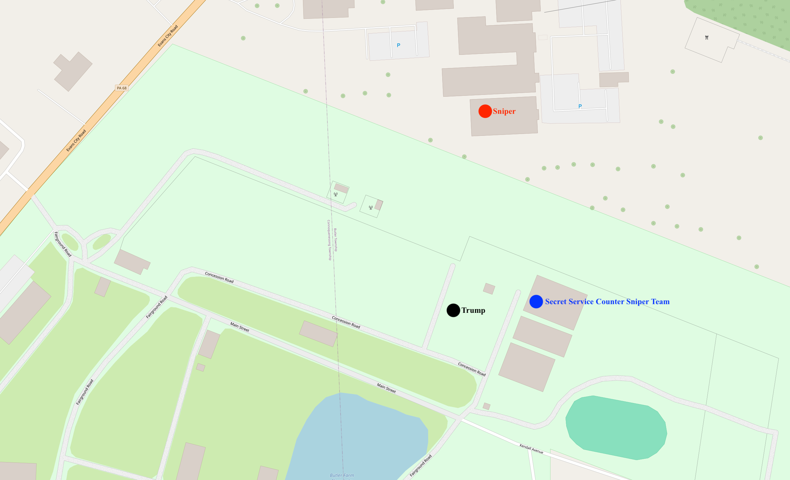
English: Diagram of the 2024 Assassination Attempt of Donald Trump |
|||
| Ngày | ||||
| Nguồn gốc | openstreetmap.org | |||
| Sáng tác |
OpenStreetMap contributors |
|||
| Giấy phép (Dùng lại tập tin) |
OpenStreetMap data is available under the Open Database License (details). Standard style map tiles are licensed as ODbL Produced Works.
|
|||
| Georeferencing | If inappropriate please set warp_status = skip to hide. |
Sources of labeled locations[1][2]
- ↑ (2024-07-13). "Shooting at a Trump Rally in Pennsylvania: Maps and Photos". The New York Times. ISSN 0362-4331.
- ↑ Trump injured, rushed from stage after shooter fired on his Pennsylvania rally (in en). NBC News (2024-07-13). Archived from the original on July 14, 2024. Retrieved on 2024-07-14.
Lịch sử tập tin
Nhấn vào ngày/giờ để xem nội dung tập tin tại thời điểm đó.
| Ngày/giờ | Hình xem trước | Kích cỡ | Thành viên | Miêu tả | |
|---|---|---|---|---|---|
| hiện tại | 02:28, ngày 14 tháng 7 năm 2024 | | 2.563×1.559 (743 kB) | Cyrogigabyte | Uploaded own work with UploadWizard |
Trang sử dụng tập tin
Có 1 trang tại Wikipedia tiếng Việt có liên kết đến tập tin (không hiển thị trang ở các dự án khác):
Sử dụng tập tin toàn cục
Những wiki sau đang sử dụng tập tin này:
- Trang sử dụng tại be.wikipedia.org
- Trang sử dụng tại ja.wikipedia.org
- Trang sử dụng tại pt.wikinews.org
- Trang sử dụng tại sw.wikipedia.org
- Trang sử dụng tại te.wikipedia.org
- Trang sử dụng tại uk.wikipedia.org