Tập tin:African-civilizations-map-pre-colonial.svg
Tập tin gốc(tập tin SVG, 1.390×1.295 điểm ảnh trên danh nghĩa, kích thước: 488 kB)

 
W3C-validity not checked.

Miêu tả

Miêu tả

Africa History Atlas

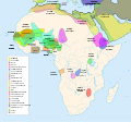
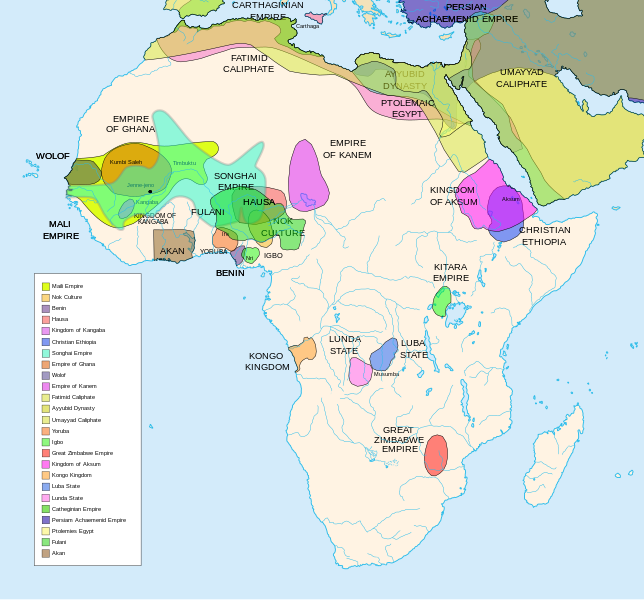
Diachronic map showing pre-colonial cultures of Africa (spanning roughly 500 BCE to 1500 CE)

This map is "an artistic interpretation" using multiple and disparate sources.
Ngày
Nguồn gốc Tác phẩm được tạo bởi người tải lên
Tác giả Jeff Israel (ZyMOS)
Phiên bản khác

Derivative works of this file:  African-civilizations-map-imperial.png

Civilizations

These civilizations are shown on the map above

Mali Empire (done):
        [4], [5], [6], [7], [8](1300), 14

Nok Culture(done):
        http://perso.orange.fr/miltiade/Civilisation_de_Nok.htm
        [5]

Fulani empire (aka sokoto empire, Sokoto Calphate, Fulani Empire of Sokoto)  (fulani people are different) (done):
        [2], [10e], [11e]
Akan States (generric term for states with the akan people)(Done): 
 [7], 
Benin: (done)
        [7],[14],[16]
Hausa (done)
        [7], [10],[16]

Kingdon of Kangaba (1000AD?) (done)
        [8](1235)

Christian Ethiopia(done)
        [5]

Songhai Empire (done)
        http://commons.wikimedia.org/wiki/Image:Mapa_shonghai.svg
        [3], [4], [5], [6], [7], [8](1300), [16]
        http://www.zum.de/whkmla/histatlas/westafrica/haxmali.html
        http://empathosnationenterprises.com/Consulate/EN-Library/Black-Studies/afempire.html

Empire of Ghana (done):
        [4], [5], [6], [7]

Wolof: (15th century) (done)
        [2],[2c],[14]

Empire of Kanem:(done)
        [15]

Fatimid caliphate(done) 909-1171AD
        [2b],[6b]

Ayyubid dynasty (done) 1171-1250ad
        [1b], [5e], [6e]

Umayyad Caliphate (done) 661-750
        [5b]

Yoruba yorubaland    (done)
        [4b],[2c]

Igbo    (done)
        [4b],

Great Zimbabwe (done):
        [5], [7]

Kingdom of aksum (Axum?) 1bc-7ad  (done)
        [12b],[14b],[15b]

Kongo Kingdom     (done)
        [1c], [2c],[15]

Luba State (done) 15-19th century
        [2c],[4c]

Lunda State (done) 15-19th century
        [2c],[4c],[16]

Carthaginian Empire(done) (220BCE) Carthage
        [2c], [3c]

Persian Achaemenid Empire (done)
        [2e],3e].4e],[

THE PTOLEMIES (done)
        [8e], [9e]

Civilizations to be added

These civilizations have not been added because the borders have not yet been confirmed, or there is some uncertainty if they are a true civilization. Please add them to the map if you are able to define the borders of these civilizations.


Mane (1000-2000)(city) [41]

Kano (independent city-state) (1000-1903):
 [14]

Kaarta (kingdom of Kaarta) (1753-1854):
 [14]

Macina (Macina Empire) (aka Dina of Massina, Sise Jihad state, and Caliphate of Hamdullahi) (1818-1862):
 [14]

Segou (city 1620):
 [14]

Kingdom of Fouta Djallon (Futa Djalon or Kingdom of Fuuta Jallon):
 [14]

Hausa Bakwai (initial stage Hausa):
 [11e]

Wassoulou Empire (Ouassoulou) (1878 - 1898) :
 [14]

Kénédougou Kingdom (Kenedougou) (1650-1898):
 [14]

Ouagadougou (15th century CITY):
 [14]

Ashanti Kingdom:
	[14]

Dahomey:
	[14]

Gando (16th century town):
	[14]

kingdom of Takrur (c. 800 - c. 1285) :
	[8](1300), [13]

Oyo empire (1400-1796)


Bornu Empire (1396-1893):
        [2],[15], [10e]

Bornu-Kanem (a portion of kanem history where they merged):
	[7],[2c]

Wodaabe (a people of africa):
	[10]

Mamluk Sultanate of Egypt (1174-1820):
	[2],[12], 

Kush?Kushite kingdom?:

Axum (see kingdom of aksum):

Buganda kingdom (changed to Unganda, but remained as Buganda people):

Lozi???:

Malawi Empire (late 15th centure and converted to Malawi Contry):

Kilwa (Kilwa Kisiwani, 9th century,  is an Islamic community is present day tanzania):
	[2c]

Abyssinia???:
        [2], [7]

Soha????:
        [2],

Nubia (Makuria, Nobatia, Alodia kingdom):
	[7], 

Kingdom of Kerma(2500BC-1520BC):

=North Central=

Sahariano??:
	[1], 

Maban????????:
        [1],

Fur(a people:
        [1],

Sudanes Central (language Central Sudanic):
        [1],

=East Central=

Sudanes Meridional???:
        [1],

Berta(language>:
        [1],

Kunama(a people):
        [1],

Komuz???instument:
        [1],

Aksumite Civilization
	[7b], [9b(maybey], [13b(aksum)]

Kingdom of Sheva???
	[8b]

Egypt
	[10b]

JolofEmpire (also called Dyolof or Wolof), wolof should be changed to this:
	[11b]


Meroe(city, capital of Kushitic Kingdom)) 
	[12b]

Bantu(ethnic group)
	[12b]

Khoisan(ethnic group)
	[12b]

Almoravid Empire
	[5c], [1f]
	
Monomotapa
	[2c],[16]

Lozi
	[2c]

Zulu Kingdom
	[2c]

Merina
	[2c]

Malawi
	[2c]

Rawanda
	[2c]

Buganada
	[2c]

Kazembe
	[4c]


Punt (3000BC-1000BC):
	location lost in time

D'mt (800BC-100BC):


Gudit (1000AD):

Zagwe Dynasty (1000-1268AD):
	[6e]
	
Solomonic dynasty (1270-1974AD)

Himyar:
	[1d]

Qataban:
	[1d]

Saba:
	[1d]

Hadhramaut:
	[1d]

Thutmoses 1
	[1e]

Ramesses II
	[1e]

Assurbanipal, empire of 
	[7e]

Mbunda Kingdom
	[12e], [13e]

Editing this page and map

Suggestions before editing this map: Be sure to confirm it with multiple sources, and that it would be considered a true civilization. Also if you add to the map please name the layers and objects to keep it organized. A lot of the civilizations on this page do not have the times they existed. If this could be added it would be very beneficial. Then the map could be easily split into eras.

References

The original map came from


Giấy phép

Tôi, người giữ bản quyền tác phẩm này, từ đây phát hành nó theo các giấy phép sau:
GNU head Bạn có quyền sao chép, phân phối và/hoặc sửa đổi tài liệu này theo những điều khoản được quy định trong Giấy phép Tài liệu Tự do GNU, phiên bản 1.2 hoặc các phiên bản mới hơn được Quỹ Phần mềm Tự do; quy định; ngoại trừ những phần không được sửa đổi, bìa trước và bìa sau. Bạn có thể xem giấy phép nói trên ở phần Giấy phép Tài liệu Tự do GNU.
w:vi:Creative Commons
ghi công chia sẻ tương tự
Tác phẩm này được phát hành theo giấy phép Creative Commons Ghi công–Chia sẻ tương tự, các phiên bản 3.0 Chưa chuyển đổi, 2.5 Chung, 2.0 Chung, và 1.0 Chung.
Bạn được phép:
  • chia sẻ – sao chép, phân phối và chuyển giao tác phẩm
  • pha trộn – để chuyển thể tác phẩm
Theo các điều kiện sau:
  • ghi công – Bạn phải ghi lại tác giả và nguồn, liên kết đến giấy phép, và các thay đổi đã được thực hiện, nếu có. Bạn có thể làm các điều trên bằng bất kỳ cách hợp lý nào, miễn sao không ám chỉ rằng người cho giấy phép ủng hộ bạn hay việc sử dụng của bạn.
  • chia sẻ tương tự – Nếu bạn biến tấu, biến đổi, hoặc làm tác phẩm khác dựa trên tác phẩm này, bạn chỉ được phép phân phối tác phẩm mới theo giấy phép y hệt hoặc tương thích với tác phẩm gốc.
Bạn có thể chọn giấy phép mà bạn muốn.

Chú thích

Ghi một dòng giải thích những gì có trong tập tin này
Map of pre-colonial African civilizations

Khoản mục được tả trong tập tin này

mô tả

checksum Tiếng Anh

458dcae2fb4eb4a66837ee9cd5c1e539750e7c18

1.295 pixel

1.390 pixel

Lịch sử tập tin

Nhấn vào ngày/giờ để xem nội dung tập tin tại thời điểm đó.

(Mới nhất | Cũ nhất) Xem (10 mới hơn) () (10 | 20 | 50 | 100 | 250 | 500)
Ngày/giờHình xem trướcKích cỡThành viênMiêu tả
hiện tại06:49, ngày 16 tháng 2 năm 2024Hình xem trước của phiên bản lúc 06:49, ngày 16 tháng 2 năm 20241.390×1.295 (488 kB)Ahiise2Changed "Bachwezi Empire" to "Kitara Empire" to be consistent with other versions of the file
04:11, ngày 20 tháng 9 năm 2011Hình xem trước của phiên bản lúc 04:11, ngày 20 tháng 9 năm 20111.390×1.295 (487 kB)Alphathonmoved rivers to the top
03:33, ngày 20 tháng 9 năm 2011Hình xem trước của phiên bản lúc 03:33, ngày 20 tháng 9 năm 20111.390×1.295 (487 kB)AlphathonOne more time…
03:27, ngày 20 tháng 9 năm 2011Hình xem trước của phiên bản lúc 03:27, ngày 20 tháng 9 năm 20111.390×1.295 (486 kB)AlphathonFound some more errors
03:16, ngày 20 tháng 9 năm 2011Hình xem trước của phiên bản lúc 03:16, ngày 20 tháng 9 năm 20111.390×1.295 (489 kB)AlphathonSome final clean-ups and fixes
02:59, ngày 20 tháng 9 năm 2011Hình xem trước của phiên bản lúc 02:59, ngày 20 tháng 9 năm 20111.390×1.295 (471 kB)AlphathonApparently I duped The Persian Archaemenid Empire (now fixed). Also fixed borders of said empire.
02:50, ngày 20 tháng 9 năm 2011Hình xem trước của phiên bản lúc 02:50, ngày 20 tháng 9 năm 20111.390×1.295 (452 kB)AlphathonReinstated "Akan" on proper vector version of the map and tidied up some sea-borders (some still need looking at)
02:02, ngày 20 tháng 9 năm 2011Hình xem trước của phiên bản lúc 02:02, ngày 20 tháng 9 năm 20111.390×1.295 (297 kB)AlphathonReverted to version as of 22:11, 20 July 2010 - previous version was not a vector image
17:42, ngày 26 tháng 3 năm 2011Hình xem trước của phiên bản lúc 17:42, ngày 26 tháng 3 năm 20112.000×1.863 (2,66 MB)Medicineman84== {{int:filedesc}} == {{Information |Description=Africa History Atlas Diachronic map showing pre-colonial cultures of Africa (spanning roughly 500 BCE to 1500 CE) This map is "an artistic interpretation" using multiple and disparate sources. |Source={
22:11, ngày 20 tháng 7 năm 2010Hình xem trước của phiên bản lúc 22:11, ngày 20 tháng 7 năm 20101.390×1.295 (297 kB)Ras67font fault resolved
(Mới nhất | Cũ nhất) Xem (10 mới hơn) () (10 | 20 | 50 | 100 | 250 | 500)
Có 4 trang tại Wikipedia tiếng Việt có liên kết đến tập tin (không hiển thị trang ở các dự án khác):

Sử dụng tập tin toàn cục

Những wiki sau đang sử dụng tập tin này:

Xem thêm các trang toàn cục sử dụng tập tin này.
Đặc tính hình