Tập tin:American Falls Niagara Falls USA from Skylon Tower on 2002-05-28.png
Kích thước hình xem trước: 800×450 điểm ảnh. Độ phân giải khác: 320×180 điểm ảnh | 640×360 điểm ảnh | 1.024×576 điểm ảnh | 1.280×720 điểm ảnh | 2.560×1.440 điểm ảnh | 5.120×2.880 điểm ảnh.
Tập tin gốc (5.120×2.880 điểm ảnh, kích thước tập tin: 22,5 MB, kiểu MIME: image/png)
Tập tin này từ Wikimedia Commons. Trang miêu tả nó ở đấy được sao chép dưới đây. Commons là kho lưu trữ tập tin phương tiện có giấy phép tự do. Bạn có thể tham gia. |
Miêu tả
| Miêu tả |
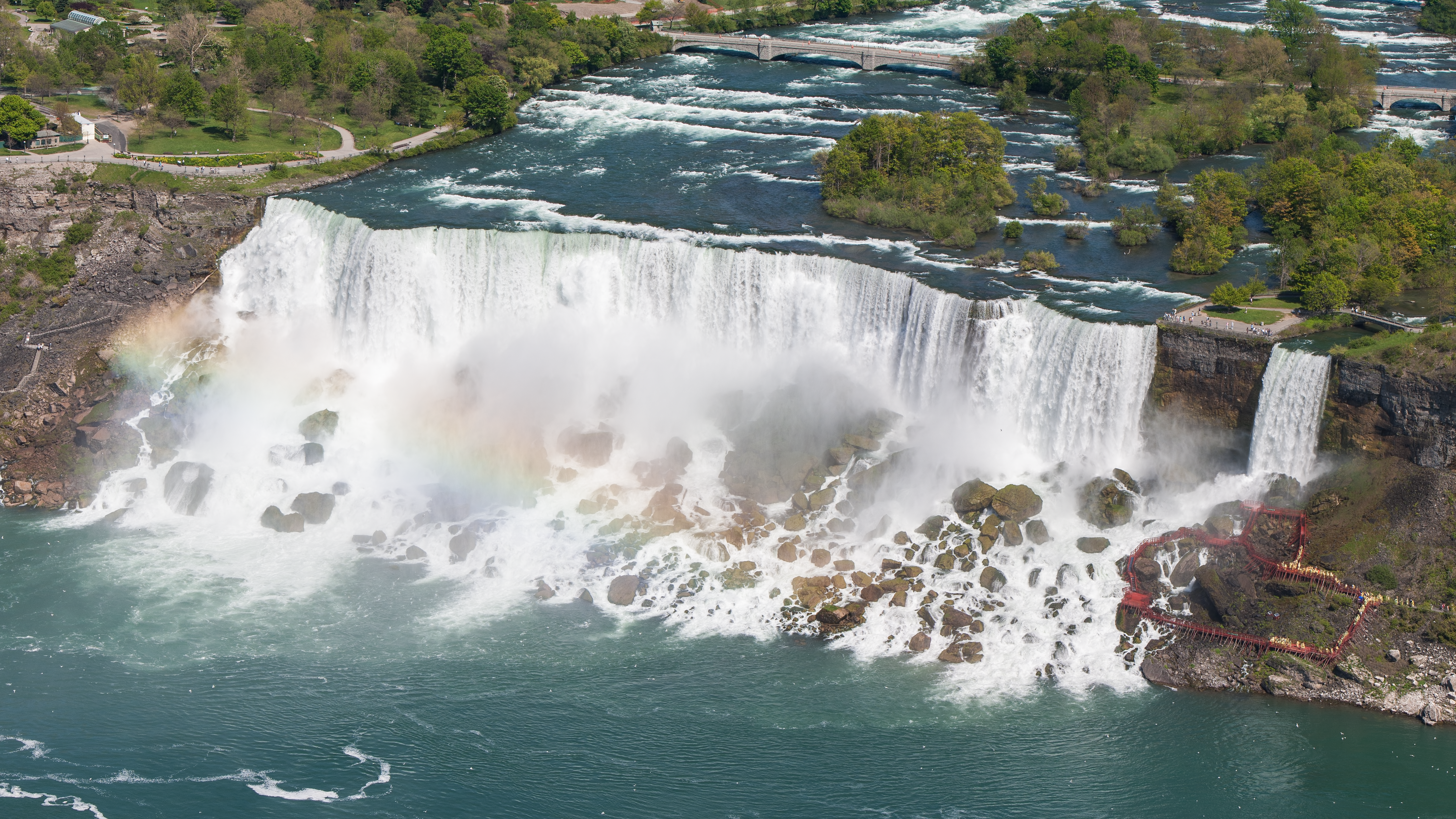
English: The American Falls and the Bridal Veil Falls of the Niagara Falls in the USA from Skylon Tower on May 28, 2002.
Deutsch: Die American Falls und die Bridal Veil Falls der Niagarafälle in den USA vom Skylon Tower aus am 28. Mai 2002.
|
||||
| Ngày | |||||
| Nguồn gốc | Tác phẩm được tạo bởi người tải lên | ||||
| Tác giả | Robert F. Tobler | ||||
| Giấy phép (Dùng lại tập tin) |
English: This photograph was taken by Robert F. Tobler and released under the license(s) stated below. You are free to use it for any purpose as long as you credit the author, the Source (Wikimedia Commons) and the license (CC-BY-SA 4.0) in close relation to the image.
Deutsch: Dieses Foto wurde von Robert F. Tobler erstellt und unter nachfolgend aufgeführter Lizenz veröffentlicht. Das Bild kann frei verwendet werden solange der Urheber, die Quelle (Wikimedia Commons) und die Lizenz (CC-BY-SA 4.0) in erkennbarem Zusammenhang mit dem Bild genannt wird.
|
||||
| Phiên bản khác |


| Vị trí máy chụp hình | | Xem hình này và các hình ảnh lân cận trên: OpenStreetMap |
|---|
Giấy phép
Tôi, người giữ bản quyền tác phẩm này, từ đây phát hành nó theo giấy phép sau:
Tập tin này được phát hành theo Giấy phép Creative Commons Ghi công–Chia sẻ tương tự 4.0 Quốc tế.
- Bạn được phép:
- chia sẻ – sao chép, phân phối và chuyển giao tác phẩm
- pha trộn – để chuyển thể tác phẩm
- Theo các điều kiện sau:
- ghi công – Bạn phải ghi lại tác giả và nguồn, liên kết đến giấy phép, và các thay đổi đã được thực hiện, nếu có. Bạn có thể làm các điều trên bằng bất kỳ cách hợp lý nào, miễn sao không ám chỉ rằng người cho giấy phép ủng hộ bạn hay việc sử dụng của bạn.
- chia sẻ tương tự – Nếu bạn biến tấu, biến đổi, hoặc làm tác phẩm khác dựa trên tác phẩm này, bạn chỉ được phép phân phối tác phẩm mới theo giấy phép y hệt hoặc tương thích với tác phẩm gốc.
| Annotations | This image is annotated: View the annotations at Commons |
Ảnh này đã được xem xét dựa trên Tiêu chuẩn hình ảnh và được đánh giá là một hình ảnh chất lượng.
|
Lịch sử tập tin
Nhấn vào ngày/giờ để xem nội dung tập tin tại thời điểm đó.
| Ngày/giờ | Hình xem trước | Kích cỡ | Thành viên | Miêu tả | |
|---|---|---|---|---|---|
| hiện tại | 05:48, ngày 13 tháng 3 năm 2016 | | 5.120×2.880 (22,5 MB) | Rftblr | correct 16:9 size |
| 05:41, ngày 13 tháng 3 năm 2016 |  | 5.121×2.880 (22,51 MB) | Rftblr | slightly better color | |
| 03:18, ngày 13 tháng 3 năm 2016 |  | 5.120×2.880 (22,46 MB) | Rftblr | tighter crop (mainly on the right) | |
| 15:54, ngày 12 tháng 3 năm 2016 |  | 5.760×2.880 (26,02 MB) | Rftblr | slightly brighter | |
| 15:42, ngày 12 tháng 3 năm 2016 |  | 5.760×2.880 (25,43 MB) | Rftblr | User created page with UploadWizard |
Trang sử dụng tập tin
Có 1 trang tại Wikipedia tiếng Việt có liên kết đến tập tin (không hiển thị trang ở các dự án khác):
Sử dụng tập tin toàn cục
Những wiki sau đang sử dụng tập tin này:
- Trang sử dụng tại ar.wikipedia.org
- Trang sử dụng tại bn.wikipedia.org
- Trang sử dụng tại ca.wikipedia.org
- Trang sử dụng tại de.wikipedia.org
- Trang sử dụng tại de.wikivoyage.org
- Trang sử dụng tại en.wikipedia.org
- Trang sử dụng tại es.wikipedia.org
- Trang sử dụng tại fa.wikipedia.org
- Trang sử dụng tại fr.wikipedia.org
- Trang sử dụng tại ha.wikipedia.org
- Trang sử dụng tại hyw.wikipedia.org
- Trang sử dụng tại it.wikipedia.org
- Trang sử dụng tại kw.wikipedia.org
- Trang sử dụng tại lb.wikipedia.org
- Trang sử dụng tại mdf.wikipedia.org
- Trang sử dụng tại nl.wikipedia.org
- Trang sử dụng tại si.wikipedia.org
- Trang sử dụng tại sq.wikipedia.org
- Trang sử dụng tại sr.wikipedia.org