Tập tin:Antarctic Peninsula satellite image.jpg

Kích thước hình xem trước: 490×599 điểm ảnh. Độ phân giải khác: 196×240 điểm ảnh | 392×480 điểm ảnh | 628×768 điểm ảnh | 837×1.024 điểm ảnh | 1.509×1.846 điểm ảnh.
Tập tin gốc (1.509×1.846 điểm ảnh, kích thước tập tin: 706 kB, kiểu MIME: image/jpeg)
Tập tin này từ Wikimedia Commons. Trang miêu tả nó ở đấy được sao chép dưới đây. Commons là kho lưu trữ tập tin phương tiện có giấy phép tự do. Bạn có thể tham gia. |
Miêu tả
| Miêu tả |
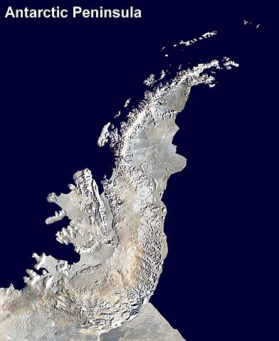
English: Antarctic Peninsula satellite image. An orthographic projection of NASA's Blue Marble data set (1 km resolution global satellite composite). "MODIS observations of polar sea ice were combined with observations of Antarctica made by the National Oceanic and Atmospheric Administration’s AVHRR sensor—the Advanced Very High Resolution Radiometer." Image was generated using a custom C program for handling the Blue Marble files, with orthographic projection formulas from MathWorld.
The black pixels are presumed to be due to missing data in the land/sea mask used in making the original Blue Marble image.
|
||
| Ngày | (UTC) | ||
| Nguồn gốc | |||
| Tác giả |
|
Giấy phép
| Tác phẩm này đã được tác giả của nó, Anna Frodesiak, phát hành vào phạm vi công cộng. Điều này có hiệu lực trên toàn thế giới. Tại một quốc gia mà luật pháp không cho phép điều này, thì: |
Nhật trình tải lên đầu tiên
This image is a derivative work of the following images:
- File:Antarctica_6400px_from_Blue_Marble.jpg licensed with PD-user
- 2006-10-05T14:21:53Z Davepape 6400x6400 (3472802 Bytes) touched up part with missing data
- 2006-10-05T07:49:09Z Davepape 6400x6400 (3472752 Bytes) {{Information |Description=[[w:Antarctica|Antarctica]]. An orthographic projection of NASA's Blue Marble data set (1 km resolution global satellite composite). "MODIS observations of polar sea ice were combined with observa
Uploaded with derivativeFX
Lịch sử tập tin
Nhấn vào ngày/giờ để xem nội dung tập tin tại thời điểm đó.
| Ngày/giờ | Hình xem trước | Kích cỡ | Thành viên | Miêu tả | |
|---|---|---|---|---|---|
| hiện tại | 23:08, ngày 5 tháng 4 năm 2009 | | 1.509×1.846 (706 kB) | Anna Frodesiak | {{Information |Description=Antarctic Peninsula satellite image. An orthographic projection of NASA's Blue Marble data set (1 km resolution global satellite composite). "MODIS observations of polar sea ice were combined with observations of Antarctica made |
Trang sử dụng tập tin
Có 1 trang tại Wikipedia tiếng Việt có liên kết đến tập tin (không hiển thị trang ở các dự án khác):
Sử dụng tập tin toàn cục
Những wiki sau đang sử dụng tập tin này:
- Trang sử dụng tại af.wikipedia.org
- Trang sử dụng tại ast.wikipedia.org
- Trang sử dụng tại bs.wikipedia.org
- Trang sử dụng tại ca.wikipedia.org
- Trang sử dụng tại da.wikipedia.org
- Trang sử dụng tại en.wikipedia.org
- Antarctic Peninsula
- Mount Jackson (Antarctica)
- Breaker Island
- Dream Island
- Christine Island
- Cormorant Island
- Eichorst Island
- Shortcut Island
- Biscoe Point
- Halfway Island (Palmer Archipelago)
- Gerlache Strait
- Hermit Island (Antarctic)
- Humble Island
- Janus Island
- Laggard Island
- Limitrophe Island
- Lipps Island
- Ohlin Island
- Outcast Islands
- Torgersen Island
- Spume Island
- Stepping Stones (islands)
- Surge Rocks
- Galindez Island
- Quintana Island
- Cobalescou Island
- Doumer Island
- Bremen Island
- Neumayer Channel
- Smooth Island (Antarctica)
- Wilhelm Archipelago
- Betbeder Islands
- Meek Channel
- Shelter Islands
- Sigma Islands
- Yalour Islands
- Yoke Island
- Tripod Island
- Zigzag Island
- Spert Island
- Indicator Island
- Intercurrence Island
Xem thêm các trang toàn cục sử dụng tập tin này.