Tập tin:BayareaUSGS.jpg

Kích thước hình xem trước: 578×600 điểm ảnh. Độ phân giải khác: 231×240 điểm ảnh | 463×480 điểm ảnh | 769×798 điểm ảnh.
Tập tin gốc (769×798 điểm ảnh, kích thước tập tin: 613 kB, kiểu MIME: image/jpeg)
Lịch sử tập tin
Nhấn vào ngày/giờ để xem nội dung tập tin tại thời điểm đó.
| Ngày/giờ | Hình xem trước | Kích cỡ | Thành viên | Miêu tả | |
|---|---|---|---|---|---|
| hiện tại | 00:08, ngày 19 tháng 4 năm 2009 |  | 769×798 (613 kB) | Yarnalgo | rmving little border on top and right and rmving USGS watermark |
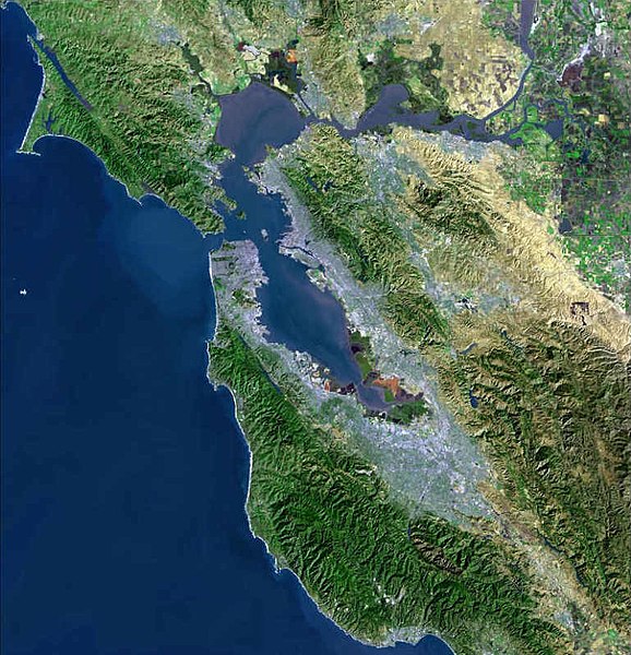
| 15:14, ngày 22 tháng 12 năm 2006 |  | 770×800 (98 kB) | Nk | Satellite map of the San Francisco Bay Area from the U.S. Geological Survey. The effect of the San Andreas Fault on the terrain can been seen on a diagonal line from the upper left corner to the lower right. The green and golden mountainous regions (wri |
Trang sử dụng tập tin
Có 2 trang tại Wikipedia tiếng Việt có liên kết đến tập tin (không hiển thị trang ở các dự án khác):
Sử dụng tập tin toàn cục
Những wiki sau đang sử dụng tập tin này:
- Trang sử dụng tại ar.wikipedia.org
- سان فرانسيسكو
- سان خوسيه (كاليفورنيا)
- مقاطعة ألاميدا (كاليفورنيا)
- مقاطعة كونترا كوستا (كاليفورنيا)
- مقاطعة مارين (كاليفورنيا)
- مقاطعة نابا (كاليفورنيا)
- مقاطعة سان ماتيو (كاليفورنيا)
- مقاطعة سانتا كلارا (كاليفورنيا)
- مقاطعة سولانو (كاليفورنيا)
- مقاطعة سونوما (كاليفورنيا)
- ستانفورد (كاليفورنيا)
- فاليجو (كاليفورنيا)
- نابا (كاليفورنيا)
- أوكلاند (كاليفورنيا)
- فريمونت (كاليفورنيا)
- هايوارد (كاليفورنيا)
- سان ماتيو (كاليفورنيا)
- ريدوود (كاليفورنيا)
- سانيفال (كاليفورنيا)
- سانتا كلارا (كاليفورنيا)
- سانتا روسا (كاليفورنيا)
- بيتالوما
- فيرفيلد (كاليفورنيا)
- مارتينز (كاليفورنيا)
- بنيسيا (كاليفورنيا)
- ريتشموند (كاليفورنيا)
- سان رافاييل (كاليفورنيا)
- أنتيوك
- منطقة خليج سان فرانسيسكو
- خليج سان فرانسيسكو
- ألاميدا (كاليفورنيا)
- ألباني (كاليفورنيا)
- أميريكان كانيون (كاليفورنيا)
- بيلمونت (كاليفورنيا)
- بيركيلي (كاليفورنيا)
- برينتوود (كاليفورنيا)
- بورلينغامي (كاليفورنيا)
- كامببيل (كاليفورنيا)
- كلايتون (كاليفورنيا)
- كونكورد (كاليفورنيا)
- كوبيرتينو (كاليفورنيا)
- دالي سيتي (كاليفورنيا)
- دانفيل (كاليفورنيا)
- ديكسون (كاليفورنيا)
- دوبلين (كاليفورنيا)
- إيست بالو ألتو (كاليفورنيا)
- إل سيرريتو (كاليفورنيا)
- إميريفيلي (كاليفورنيا)
- فوستير سيتي (كاليفورنيا)
- غيلروي (كاليفورنيا)
Xem thêm các trang toàn cục sử dụng tập tin này.
