Tập tin:Britain and Ireland satellite image bright.png

Kích thước hình xem trước: 522×600 điểm ảnh. Độ phân giải khác: 209×240 điểm ảnh | 418×480 điểm ảnh | 668×768 điểm ảnh | 1.024×1.177 điểm ảnh.
Tập tin gốc (1.024×1.177 điểm ảnh, kích thước tập tin: 2,21 MB, kiểu MIME: image/png)
Tập tin này từ Wikimedia Commons. Trang miêu tả nó ở đấy được sao chép dưới đây. Commons là kho lưu trữ tập tin phương tiện có giấy phép tự do. Bạn có thể tham gia. |
Miêu tả
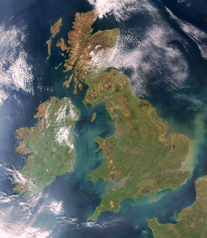
Brightened version of Image:United_Kingdom_satellite_image.png. Enhancement performed with w:en:the GIMP.
Giấy phép
| This file is in the public domain in the United States because it was solely created by NASA. NASA copyright policy states that "NASA material is not protected by copyright unless noted". (See Template:PD-USGov, NASA copyright policy page or JPL Image Use Policy.) | ||
 |
Warnings:
|
Lịch sử tập tin
Nhấn vào ngày/giờ để xem nội dung tập tin tại thời điểm đó.
| Ngày/giờ | Hình xem trước | Kích cỡ | Thành viên | Miêu tả | |
|---|---|---|---|---|---|
| hiện tại | 19:32, ngày 7 tháng 4 năm 2009 | | 1.024×1.177 (2,21 MB) | HighKing | Used original NASA source instead of version that had political border drawn in |
| 18:24, ngày 5 tháng 4 năm 2009 |  | 917×1.124 (1,15 MB) | HighKing | Cropped a little finer | |
| 18:06, ngày 5 tháng 4 năm 2009 |  | 934×1.284 (1,87 MB) | HighKing | {{Information |Description={{en|1=Brightened and correctly renamed version of Image:United_Kingdom_satellite_image.png. Enhancement performed with w:en:the GIMP.}} |Source=NASA |Author=NASA |Date= |Permission= |other_versions= }} <!--{{ImageUplo |
Trang sử dụng tập tin
Chưa có trang nào ở Wikipedia tiếng Việt liên kết đến tập tin này.
Sử dụng tập tin toàn cục
Những wiki sau đang sử dụng tập tin này:
- Trang sử dụng tại en.wikipedia.org
- Wikipedia:Userboxes/Location/Europe
- Names of the British Isles
- User:CsikosLo
- User:MariAdkins
- User:Tk420
- British nationalism
- User talk:HighKing/BritishIsles
- Template:User British-Isles
- User:KingKarp
- User:Knox490
- User:Byzantium Purple
- Wikipedia:Userboxes/Life/Ancestry
- Wikipedia talk:Userboxes/Archive 13
- Template:User British Isles≠UK,GBorEngland
- User:Adam9007
- Wikipedia:Userboxes/Life/Ethnicity
- User:Clawraich (Dalek)
- User:Mmitchell10
- User:Volksliam
- User:Nicnote
- User:Specto73
- User:Chris0282
- User:Markus1423
- User:RyTellyFan91
- User:HurricaneKappa
- User:SHISHIR DUA
- User:HurricaneKappa/sandbox/My Userboxes
- User:Shadestar474
- User:LowBattsMatt
- Trang sử dụng tại en.wikisource.org
- Trang sử dụng tại it.wikipedia.org
- Trang sử dụng tại ja.wikipedia.org
- Trang sử dụng tại no.wikipedia.org
- Trang sử dụng tại si.wikipedia.org
- Trang sử dụng tại zh.wikipedia.org