Tập tin:Buck Hill Farm Covered Bridge Three Quarters HDR 2950px.jpg

Tập tin gốc (2.950×1.930 điểm ảnh, kích thước tập tin: 3,92 MB, kiểu MIME: image/jpeg)
Tập tin này từ Wikimedia Commons. Trang miêu tả nó ở đấy được sao chép dưới đây. Commons là kho lưu trữ tập tin phương tiện có giấy phép tự do. Bạn có thể tham gia. |
|
This is an image of a place or building that is listed on the National Register of Historic Places in the United States of America. Its reference number is 80003528. |
| Vị trí máy chụp hình | | Xem hình này và các hình ảnh lân cận trên: OpenStreetMap |
|---|
| Miêu tả |
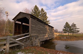
A three-quarters view photograph of the Buck Hill Farm Covered Bridge. The bridge is located in Lancaster County, Pennsylvania. Special thanks to the private owners of this bridge who gave permission for this photo to be taken.
|
||||||
| Ngày | |||||||
| Nguồn gốc | Self-photographed | ||||||
| Tác giả | Photo by and (c)2007 Derek Ramsey (Ram-Man) | ||||||
| Giấy phép (Dùng lại tập tin) |
You may NOT use this image on your own web site or anywhere else unless you release this image and any derivative works (which may include the web page or other medium where this image is used, if it is not considered a "collective work") by following the terms of the following license. Any other use will be considered a breach of copyright law. Please do not copy this image illegally by ignoring the terms of the license, as it is not in the public domain. If you would like special permission to use, license, or purchase the image or prints of the image, or for use in any other fashion or would simply like a copy of the original file, please contact me or email me first to ask. Please see the non-legalese usage guide for more information. Note: While you are not required to do so by the license, please consider letting me know when you reuse one of my photograph images, as a courtesy. Tôi, người giữ bản quyền tác phẩm này, từ đây phát hành nó theo giấy phép sau:
|
||||||

Lịch sử tập tin
Nhấn vào ngày/giờ để xem nội dung tập tin tại thời điểm đó.
| Ngày/giờ | Hình xem trước | Kích cỡ | Thành viên | Miêu tả | |
|---|---|---|---|---|---|
| hiện tại | 02:55, ngày 10 tháng 12 năm 2007 | | 2.950×1.930 (3,92 MB) | Ram-Man | {{Information |Description=A three-quarters view photograph of the Buck Hill Farm Covered Bridge. The bridge is located in Lancaster County, Pennsylvania. Special thanks to the |
Trang sử dụng tập tin
Sử dụng tập tin toàn cục
Những wiki sau đang sử dụng tập tin này:
- Trang sử dụng tại en.wikipedia.org
- Warwick Township, Lancaster County, Pennsylvania
- List of covered bridges in Lancaster County, Pennsylvania
- National Register of Historic Places listings in Lancaster County, Pennsylvania
- Buck Hill Farm Covered Bridge
- List of covered bridges on the National Register of Historic Places in Pennsylvania
- Trang sử dụng tại es.wikipedia.org
- Trang sử dụng tại fr.wikipedia.org
- Trang sử dụng tại sv.wikipedia.org
- Trang sử dụng tại uk.wikipedia.org
- Trang sử dụng tại www.wikidata.org