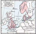
Tập tin:Cnut 1014 1035.jpg

Kích thước hình xem trước: 627×599 điểm ảnh. Độ phân giải khác: 251×240 điểm ảnh | 502×480 điểm ảnh | 765×731 điểm ảnh.
Tập tin gốc (765×731 điểm ảnh, kích thước tập tin: 284 kB, kiểu MIME: image/jpeg)
Lịch sử tập tin
Nhấn vào ngày/giờ để xem nội dung tập tin tại thời điểm đó.
| Ngày/giờ | Hình xem trước | Kích cỡ | Thành viên | Miêu tả | |
|---|---|---|---|---|---|
| hiện tại | 15:33, ngày 25 tháng 5 năm 2019 |  | 765×731 (284 kB) | Hohum | Correction |
| 15:27, ngày 25 tháng 5 năm 2019 |  | 765×731 (285 kB) | Hohum | Cleanup | |
| 18:26, ngày 17 tháng 4 năm 2013 |  | 765×731 (169 kB) | Hohum | Levels | |
| 17:34, ngày 23 tháng 3 năm 2006 |  | 765×731 (129 kB) | Thomas81 | '''Da''': Knud 2. Stores erobninger, 1014-1035. '''En''': Dominions of Canute the Great, 1014-1035. Historical Atlas by William R. Shepherd "Courtesy of the University of Texas Libraries, The University of Texas at Austin." |
Trang sử dụng tập tin
Có 1 trang tại Wikipedia tiếng Việt có liên kết đến tập tin (không hiển thị trang ở các dự án khác):
Sử dụng tập tin toàn cục
Những wiki sau đang sử dụng tập tin này:
- Trang sử dụng tại be-tarask.wikipedia.org
- Trang sử dụng tại be.wikipedia.org
- Trang sử dụng tại bs.wikipedia.org
- Trang sử dụng tại da.wikipedia.org
- Trang sử dụng tại da.wikibooks.org
- Trang sử dụng tại de.wikipedia.org
- Trang sử dụng tại en.wikipedia.org
- Trang sử dụng tại et.wikipedia.org
- Trang sử dụng tại fi.wikipedia.org
- Trang sử dụng tại fr.wikipedia.org
- Trang sử dụng tại fy.wikipedia.org
- Trang sử dụng tại hy.wikipedia.org
- Trang sử dụng tại id.wikipedia.org
- Trang sử dụng tại ja.wikipedia.org
- Trang sử dụng tại lv.wikipedia.org
- Trang sử dụng tại ru.wikipedia.org
- Trang sử dụng tại sh.wikipedia.org
- Trang sử dụng tại sr.wikipedia.org
- Trang sử dụng tại test2.wikipedia.org
- Trang sử dụng tại zh.wikipedia.org

