Tập tin:Europe rail electrification en.svg

Kích thước bản xem trước PNG này của tập tin SVG: 688×520 điểm ảnh. Độ phân giải khác: 318×240 điểm ảnh | 635×480 điểm ảnh | 1.016×768 điểm ảnh | 1.280×967 điểm ảnh | 2.560×1.935 điểm ảnh.
Tập tin gốc (tập tin SVG, 688×520 điểm ảnh trên danh nghĩa, kích thước: 399 kB)
Tập tin này từ Wikimedia Commons. Trang miêu tả nó ở đấy được sao chép dưới đây. Commons là kho lưu trữ tập tin phương tiện có giấy phép tự do. Bạn có thể tham gia. |
| Miêu tả |
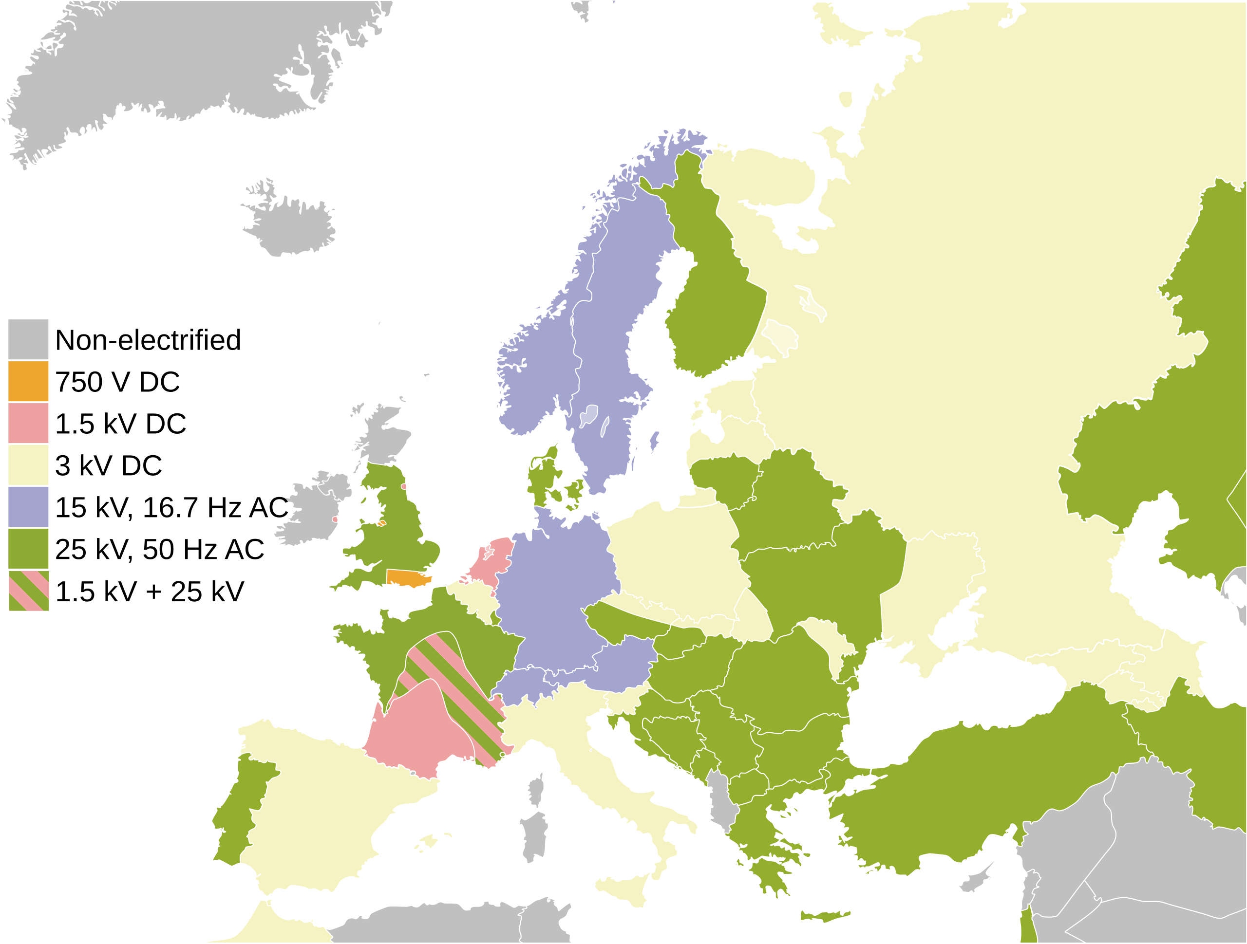
English: Map of the railway electrification systems in Europe
Italiano: Mappa del sistema di elettrificazione ferroviaria in Europa |
| Ngày | |
| Nguồn gốc | File:Europe rail electrification.png |
| Tác giả |
Vectơ:
This SVG _?_ includes elements that have been taken or adapted from this _?_: |
| Phiên bản khác | Derivative works of this file: Europe rail electrification de.svg |
| SVG genesis |
| Tôi, người giữ bản quyền của tác phẩm này, chuyển tác phẩm này vào phạm vi công cộng. Điều này có giá trị trên toàn thế giới. Tại một quốc gia mà luật pháp không cho phép điều này, thì: Tôi cho phép tất cả mọi người được quyền sử dụng tác phẩm này với bất cứ mục đích nào, không kèm theo bất kỳ điều kiện nào, trừ phi luật pháp yêu cầu những điều kiện đó. |
Nhật trình tải lên đầu tiên
This image is a derivative work of the following images:
- {{F|Europe_rail_electrification.png|-} licensed with PD-self
- 2009-06-19T01:36:39Z Addams71 450x422 (15616 Bytes) Southeast of Slovakia is not under 25 kV 50 Hz.
- 2009-06-11T19:40:56Z Wangi 450x422 (10607 Bytes) No electrification north of the Central Belt in Scotland
- 2007-10-10T01:27:42Z Jklamo 450x422 (11493 Bytes) small updates, Ireland and Ukraine
- 2007-07-31T20:25:47Z Jklamo 450x422 (11385 Bytes) Map of railway electrification systems in Europe {{legend|#eea631|750 V DC}} {{legend|#a3a5ce|15 kV AC}} {{legend|#f5f0bb|3 kV DC}} {{legend|#eda1a0|1,5 kV DC}} {{legend|#94af2e|25 kV DC}} {{legend|#cdcfd0|non-electrified}}
- File:Blank map europe.svg licensed with PD-USGov-CIA-WF
- 2010-04-18T12:24:45Z Avala 680x520 (528468 Bytes) '
- 2010-04-13T20:46:30Z Patrickneil 680x520 (543089 Bytes) Fut.Perf. added some islands in October, and whether or not the map has Kosovo, it should have the islands
- 2010-04-12T09:04:50Z Zirland 680x520 (528468 Bytes) Reverted to version as of 13:23, 5 December 2009
- 2010-04-09T16:29:37Z Anka Friedrich 680x520 (523284 Bytes) * removed hard coded styles in paths, which prevent colors beeing set by styles for ids or classes * removed style style2412, which colored timezones in southern europe
- 2009-12-05T13:23:39Z Avala 680x520 (528468 Bytes) '
- 2009-10-17T17:24:14Z NuclearVacuum 680x520 (543089 Bytes) some minor editings
- 2009-10-17T14:34:47Z Future Perfect at Sunrise 680x520 (542517 Bytes) added some Greek islands
- 2009-03-25T20:06:19Z Samulili 680x520 (533055 Bytes) Reverted to version as of 15:29, 24 March 2009
- 2009-03-24T23:22:45Z Avala 680x520 (528468 Bytes) this is the original file. upload an alternative for alternative views. simle as that.
- 2009-03-24T15:29:37Z Patrickneil 680x520 (533055 Bytes) The are blank alternatives, that without Kosovo, make this a duplicate file
- 2009-03-20T22:30:51Z Avala 680x520 (528468 Bytes) Reverted to version as of 21:10, 27 May 2007 (original version)
- 2008-10-26T21:20:07Z Cradel 680x520 (533055 Bytes) there is another version of this image
- 2008-10-26T17:25:49Z Avala 680x520 (528468 Bytes) didn't we agree to have alternative files that include disputed territories? this way it is POV, who decides which one deserves to be shown as a country more, Kosovo, Palestine, TRNC, Abkhazia etc.
- 2008-10-25T13:36:13Z Cradel 680x520 (533055 Bytes) what ?
- 2008-10-24T22:42:12Z Avala 680x520 (528468 Bytes) '
- 2008-09-22T13:35:30Z Cradel 680x520 (533055 Bytes) user has been warned
- 2008-09-22T02:11:46Z Tocino 680x520 (528468 Bytes) Reverted to version as of 17:38, 19 September 2008
- 2008-09-20T11:36:04Z Cradel 680x520 (533055 Bytes) Reverted to version as of 18:23, 17 September 2008
- 2008-09-19T17:38:55Z Tocino 680x520 (528468 Bytes) Reverted to version as of 18:12, 17 September 2008
- 2008-09-17T18:23:13Z Cradel 680x520 (533055 Bytes) look at the "other versions" section
- 2008-09-17T18:12:42Z Tocino 680x520 (528468 Bytes) Kosovo is not internationally recognized and this map is used for more than just CIA purposes
- 2008-09-16T16:01:06Z Cradel 680x520 (533055 Bytes) CIA recognises Kosovo, this is their map, do not vandalise it
- 2008-09-16T15:39:16Z Tocino 680x520 (528468 Bytes) Reverted to version as of 00:01, 16 September 2008
- 2008-09-16T10:07:44Z Cradel 680x520 (533055 Bytes) it is a god dammed CIA map
- 2008-09-16T00:01:36Z Tocino 680x520 (528468 Bytes) Reverted to version as of 17:23, 15 September 2008
- 2008-09-15T20:44:48Z Cradel 680x520 (533055 Bytes) Reverted to version as of 19:15, 14 September 2008
- 2008-09-15T17:23:28Z Tocino 680x520 (528468 Bytes) Reverted to version as of 17:03, 14 September 2008
- 2008-09-14T19:15:53Z Cradel 680x520 (533055 Bytes) sigh, please look her : https://www.cia.gov/library/publications/the-world-factbook/geos/kv.html
- 2008-09-14T17:03:29Z Milosevo 680x520 (528468 Bytes) Reverted to version as of 14:45, 13 September 2008 CIA recognizes cosovo? What? And tomorrow ROSKOSMOS recognizes covoso ..
- 2008-09-13T18:08:41Z Cradel 680x520 (533055 Bytes) fix
- 2008-09-13T18:01:06Z Cradel 680x520 (530422 Bytes) this is CIA map, which recognises kosovo
- 2008-09-13T14:45:29Z Avala 680x520 (528468 Bytes) '
- 2008-08-06T20:03:48Z Cradel 680x520 (530422 Bytes) Reverted to version as of 16:17, 4 August 2008
- 2008-08-05T04:35:29Z Rokerismoravee 680x520 (528468 Bytes) Reverted to version as of 14:46, 4 August 2008
- 2008-08-04T16:17:13Z Cradel 680x520 (530422 Bytes) Reverted to version as of 12:09, 3 August 2008
- 2008-08-04T14:46:55Z Rokerismoravee 680x520 (528468 Bytes) Reverted to version as of 13:14, 2 August 2008
- 2008-08-03T12:09:59Z Cradel 680x520 (530422 Bytes) again : what are you talking about
- 2008-08-02T13:14:48Z Milosevo 680x520 (528468 Bytes) Territory of Kosovo isn't correct
- 2008-08-02T12:48:39Z Cradel 680x520 (530422 Bytes) this map was taken from the CIA world Factbook, which recognises Kosovo so please
- 2008-08-01T21:28:39Z Rokerismoravee 680x520 (528468 Bytes) Reverted to version as of 12:54, 1 August 2008
- 2008-08-01T19:07:24Z Cradel 680x520 (530422 Bytes) Reverted to version as of 20:44, 9 June 2008
- 2008-08-01T12:54:32Z Rokerismoravee 680x520 (528468 Bytes) Reverted to version as of 17:34, 9 June 2008
- 2008-06-09T20:44:17Z Cradel 680x520 (530422 Bytes) Reverted to version as of 17:01, 9 June 2008
- 2008-06-09T17:34:51Z Milosevo 680x520 (528468 Bytes) Reverted to version as of 14:14, 9 June 2008
- 2008-06-09T17:01:41Z Cradel 680x520 (530422 Bytes) Reverted to version as of 20:14, 8 June 2008
- 2008-06-09T14:14:04Z Milosevo 680x520 (528468 Bytes) revert, vandalism. No UN-Member
- 2008-06-08T20:14:58Z Cradel 680x520 (530422 Bytes) Reverted vandalism
- 2008-06-08T15:21:43Z Milosevo 680x520 (528468 Bytes) Reverted to version as of 21:10, 27 May 2007
- 2008-05-30T12:01:01Z Cradel 680x520 (530422 Bytes) + Kosovo
- 2007-05-27T21:10:55Z Ssolbergj 680x520 (528468 Bytes) '
Uploaded with derivativeFX
Lịch sử tập tin
Nhấn vào ngày/giờ để xem nội dung tập tin tại thời điểm đó.
| Ngày/giờ | Hình xem trước | Kích cỡ | Thành viên | Miêu tả | |
|---|---|---|---|---|---|
| hiện tại | 05:50, ngày 6 tháng 9 năm 2022 | | 688×520 (399 kB) | Рагин1987 | Correction |
| 05:47, ngày 6 tháng 9 năm 2022 |  | 680×520 (557 kB) | Рагин1987 | Added countries | |
| 11:52, ngày 30 tháng 5 năm 2022 |  | 688×520 (399 kB) | Guerillero | Reverted to version as of 18:07, 21 June 2021 (UTC) new versions are blank | |
| 11:00, ngày 29 tháng 5 năm 2022 |  | 3.200×2.419 (17 kB) | Kieran1398 | Reverted to version as of 10:30, 29 May 2022 (UTC) | |
| 11:00, ngày 29 tháng 5 năm 2022 |  | 860×650 (11 kB) | Kieran1398 | added the Isle of Wight and put holy island on the map | |
| 10:55, ngày 29 tháng 5 năm 2022 |  | 688×520 (399 kB) | Kieran1398 | Reverted to version as of 18:07, 21 June 2021 (UTC) i forgot to scale down the svg | |
| 10:30, ngày 29 tháng 5 năm 2022 |  | 3.200×2.419 (17 kB) | Kieran1398 | added the Isle of Wight and put holy island on the map | |
| 18:07, ngày 21 tháng 6 năm 2021 |  | 688×520 (399 kB) | Voello | Changed the Hebrides, Orkney, Shetland and Faroe islands to non-electrified, as they do not have any electrified railways | |
| 17:58, ngày 20 tháng 6 năm 2021 |  | 688×520 (397 kB) | Voello | Corrected colouring of DART in Ireland | |
| 14:51, ngày 15 tháng 1 năm 2020 |  | 688×520 (397 kB) | Razorblack | Added white background below transparency. Colored in Iran, Kazakhstan, Uzbekistan, Israel with 25kV, 50Hz. |
Trang sử dụng tập tin
Có 1 trang tại Wikipedia tiếng Việt có liên kết đến tập tin (không hiển thị trang ở các dự án khác):
Sử dụng tập tin toàn cục
Những wiki sau đang sử dụng tập tin này:
- Trang sử dụng tại ar.wikipedia.org
- Trang sử dụng tại bg.wikipedia.org
- Trang sử dụng tại bn.wikipedia.org
- Trang sử dụng tại cs.wikipedia.org
- Trang sử dụng tại de.wikipedia.org
- Trang sử dụng tại en.wikipedia.org
- Trang sử dụng tại es.wikipedia.org
- Trang sử dụng tại fr.wikipedia.org
- Trang sử dụng tại hu.wikipedia.org
- Trang sử dụng tại id.wikipedia.org
- Trang sử dụng tại ko.wikipedia.org
- Trang sử dụng tại lb.wikipedia.org
- Trang sử dụng tại mk.wikipedia.org
- Trang sử dụng tại th.wikipedia.org
- Trang sử dụng tại uk.wikipedia.org
- Trang sử dụng tại uz.wikipedia.org