Tập tin:FRYugoMap2k.jpg

Không có độ phân giải cao hơn.
FRYugoMap2k.jpg (351×378 điểm ảnh, kích thước tập tin: 116 kB, kiểu MIME: image/jpeg)
Tập tin này từ Wikimedia Commons. Trang miêu tả nó ở đấy được sao chép dưới đây. Commons là kho lưu trữ tập tin phương tiện có giấy phép tự do. Bạn có thể tham gia. |
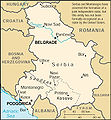
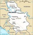
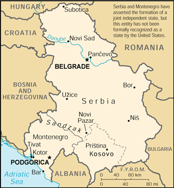
This is a map of The Federal Republic of Yugoslavia (Serbia and Montenegro) [FRY (S&M)] from as the 2000 CIA World Factbook as mirrored by the PCL.
[]
-

-
 English 2000
 -
 English 2006
 -
 English 2006
 -
 English 2008
 -
 English 2008
 -
 español 2008
 -
 magyar 2008


This image is in the public domain because it contains materials that originally came from the United States Central Intelligence Agency's World Factbook.
|
 |
Lịch sử tập tin
Nhấn vào ngày/giờ để xem nội dung tập tin tại thời điểm đó.
| Ngày/giờ | Hình xem trước | Kích cỡ | Thành viên | Miêu tả | |
|---|---|---|---|---|---|
| hiện tại | 05:18, ngày 6 tháng 2 năm 2007 | | 351×378 (116 kB) | Hoshie | This is a map of The Federal Republic of Yugoslavia (Serbia and Montenegro) [FRY (S&M)] from as the [http://www.umsl.edu/services/govdocs/wofact2000/geos/sr.html 2000 CIA World Factbook] as mirrored by the [http://ww |
Trang sử dụng tập tin
Có 1 trang tại Wikipedia tiếng Việt có liên kết đến tập tin (không hiển thị trang ở các dự án khác):
Sử dụng tập tin toàn cục
Những wiki sau đang sử dụng tập tin này:
- Trang sử dụng tại en.wikipedia.org
- Trang sử dụng tại es.wikipedia.org
- Trang sử dụng tại fa.wikipedia.org
- Trang sử dụng tại fr.wikipedia.org
- Trang sử dụng tại ja.wikipedia.org
- Trang sử dụng tại kk.wikipedia.org
- Trang sử dụng tại mr.wikipedia.org
- Trang sử dụng tại nl.wikipedia.org
- Trang sử dụng tại zh.wikipedia.org