Tập tin:German Confederation 1815.svg

Kích thước bản xem trước PNG này của tập tin SVG: 450×456 điểm ảnh. Độ phân giải khác: 237×240 điểm ảnh | 474×480 điểm ảnh | 758×768 điểm ảnh | 1.011×1.024 điểm ảnh | 2.021×2.048 điểm ảnh.
Tập tin gốc (tập tin SVG, 450×456 điểm ảnh trên danh nghĩa, kích thước: 813 kB)
Tập tin này từ Wikimedia Commons. Trang miêu tả nó ở đấy được sao chép dưới đây. Commons là kho lưu trữ tập tin phương tiện có giấy phép tự do. Bạn có thể tham gia. |
Miêu tả


.svg)
.svg)
.svg)
.svg)
.svg)


.svg)
.svg)
.svg)


.png)
.png)


.svg)


.svg)

.svg)


.svg)
.svg)
.svg)
.svg)


.svg)
.png)


.svg)


.svg)
.svg)


.svg)


.svg)


.svg)
.svg)
.svg)
.svg)
.svg)
.svg)
.svg)
_cropped.svg)
.svg)
.svg)
.svg)
.svg)
.svg)
.svg)
.svg)
.svg)
.svg)
.svg)
.svg)
.svg)
.svg)
.svg)
.svg)
.svg)
.svg)
.svg)
.svg)
.svg)
.svg)
.svg)
.svg)
.svg)
.svg)
.svg)
.svg)
.svg)
.svg)
.svg)
.svg)
.svg)
.svg)
.svg)
.svg)
.svg)
.svg)
.svg)
.svg)
.svg)
.svg)
.svg)
.svg)
.svg)
.svg)
Giấy phép
Tập tin này được phát hành theo Giấy phép Creative Commons Ghi công - Chia sẻ tương tự 3.0 Chưa chuyển đồi
- Bạn được phép:
- chia sẻ – sao chép, phân phối và chuyển giao tác phẩm
- pha trộn – để chuyển thể tác phẩm
- Theo các điều kiện sau:
- ghi công – Bạn phải ghi lại tác giả và nguồn, liên kết đến giấy phép, và các thay đổi đã được thực hiện, nếu có. Bạn có thể làm các điều trên bằng bất kỳ cách hợp lý nào, miễn sao không ám chỉ rằng người cho giấy phép ủng hộ bạn hay việc sử dụng của bạn.
- chia sẻ tương tự – Nếu bạn biến tấu, biến đổi, hoặc làm tác phẩm khác dựa trên tác phẩm này, bạn chỉ được phép phân phối tác phẩm mới theo giấy phép y hệt hoặc tương thích với tác phẩm gốc.
Nhật trình tải lên đầu tiên
This image is a derivative work of the following images:
- File:Blank_map_of_Europe.svg licensed with Cc-by-sa-2.5
- 2012-02-21T16:27:27Z Alphathon 680x520 (614699 Bytes) Updated Metadata and the boarders/coastlines along the western coast of the Black Sea
- 2011-09-19T22:57:58Z Alphathon 680x520 (603759 Bytes) Added North/Northern Cyprus
- 2011-08-23T10:26:48Z Heb 680x520 (604212 Bytes) Added [[:en:Bornholm]] (taken from [[:File:Denmark blank map.svg]])
- 2011-04-12T00:40:40Z Alphathon 680x520 (602549 Bytes) Upgraded Sicily based on "File:Freeworldmaps-sicily.jpg". Upgraded Malta based on "File:Map of Malta 2.png". Simplified Croatian borders.
- 2011-04-10T21:43:04Z Alphathon 680x520 (607359 Bytes) Upgraded Croatia, Bosnia & Herzegovina, Slovenia and surrounding countries based on data from "File:Kroatien - Politische Gliederung (Karte).png"
- 2011-04-10T20:05:09Z Alphathon 680x520 (568373 Bytes) Improved Serbia, Montenegro and surrounding countries using data from "File:Serbia Map.png". Fixed Serbia-Montenegro border. Added Kosovo (using dashed border, since it is not a universally recognised nation, and left the lan
- 2011-04-10T15:55:02Z Alphathon 680x520 (524980 Bytes) Tweaked Ukraine and surrounding countries based on data from "File:Up-map.png"
- 2011-04-10T04:02:09Z Alphathon 680x520 (511168 Bytes) Improved Greece, Albania, F.Y.R. Macedonia and Bulgaria based on "File:Greece topo.jpg"
- 2011-04-10T02:48:52Z Alphathon 680x520 (505569 Bytes) Tweaked Germany and surrounding countries based on info from "File:Germany_general_map.png"
- 2011-04-10T01:54:05Z Alphathon 680x520 (493733 Bytes) Converted all lakes back to separate layer. Added Finish lakes and tweaked Finland shape based on "File:Finland 1996 CIA map.jpg". Added Swiss lakes based on "File:Suisse cantons.svg". Tweaked Scotland and added Lochs.
- 2011-04-10T00:07:54Z Alphathon 680x520 (450120 Bytes) Improved England outline and added Isle of Wight based on "File:England Regions - Blank.svg". Improved Denmark based on "File:2 digit postcode danmark.png". Improved Sweden based on "File:Map of Sweden, CIA, 1996.jpg"
- 2011-04-08T15:53:07Z Alphathon 680x520 (438878 Bytes) Upgraded/fixed various parts of the map. Details: *Some minor fixes to Ireland and added some of the larger lakes based on [[:File:Ireland_trad_counties_named.svg]] *Pretty major fixes to Scotland (mainly the west coast and i
- 2008-09-17T09:50:25Z F7 680x520 (531491 Bytes)
- 2008-09-17T09:42:57Z F7 680x520 (2353 Bytes)
- 2008-05-26T19:04:07Z Collard 680x520 (531491 Bytes) uploading on behalf of [[User:Checkit]], direct complaints to him plox: 'Moved countries out of the "outlines" group, removed "outlines" style class, remove separate style information for Russia'
- 2008-04-30T01:38:52Z TimothyBourke 680x520 (531767 Bytes) Changed the country code of Serbia to RS per [http://en.wikipedia.org/wiki/Serbian_country_codes] and the file [http://www.iso.org/iso/iso3166_en_code_lists.txt].
- 2008-02-08T22:44:37Z CarolSpears 680x520 (531767 Bytes) validated
- 2007-07-10T11:47:59Z MrWeeble 680x520 (533112 Bytes) Updated to include British Crown Dependencies as seperate entities and regroup them as "British Islands", with some simplifications to the XML and CSS
- 2007-05-14T17:17:34Z Zirland 680x520 (540659 Bytes) serbia and montenegro
- 2007-03-30T20:40:49Z W!B: 680x520 (538830 Bytes) minor corr: update nl:Ijsselmeer, del fi:lakes (all small), add ru:lake Oneka (all ref maps.google), glued northern irland back to ie ;)
- 2007-02-05T18:44:32Z Maix 680x520 (538295 Bytes) cropped
- 2007-02-04T15:07:29Z Maix 680x520 (538310 Bytes) {{Information |Description=A blank Map of Europe in SVG format. Every country has an id which is its ISO-3116-1-ALPHA2 code in lower case for easy coloring. |Source=Image based on [[Image:Europe_countries.svg|]] by [[User:Ti
Uploaded with derivativeFX
Lịch sử tập tin
Nhấn vào ngày/giờ để xem nội dung tập tin tại thời điểm đó.
| Ngày/giờ | Hình xem trước | Kích cỡ | Thành viên | Miêu tả | |
|---|---|---|---|---|---|
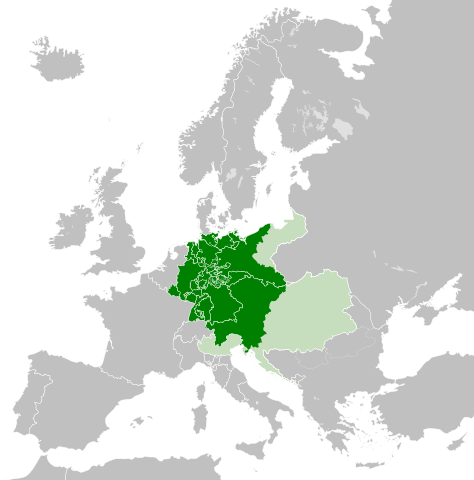
| hiện tại | 11:19, ngày 4 tháng 5 năm 2021 | | 450×456 (813 kB) | E-960 | Correction: in 1815 Venetian Province was given to Austria by the terms of the Final Act of the Congress of Vienna |
| 18:57, ngày 11 tháng 8 năm 2013 |  | 450×456 (812 kB) | Alphathon | == {{int:filedesc}} == {{Information |Description={{en|Map of the en:German Confederation, circa 1815, following the Congress of Vienna. The territory of the en:Austrian Empire and en:Kingdom of Prussia not ... |
Trang sử dụng tập tin
Có 1 trang tại Wikipedia tiếng Việt có liên kết đến tập tin (không hiển thị trang ở các dự án khác):
Sử dụng tập tin toàn cục
Những wiki sau đang sử dụng tập tin này:
- Trang sử dụng tại azb.wikipedia.org
- Trang sử dụng tại bg.wikipedia.org
- Trang sử dụng tại cs.wikipedia.org
- Trang sử dụng tại de.wikipedia.org
- Trang sử dụng tại en.wikipedia.org
- Trang sử dụng tại es.wikipedia.org
- Trang sử dụng tại eu.wikipedia.org
- Trang sử dụng tại hr.wikipedia.org
- Trang sử dụng tại id.wikipedia.org
- Trang sử dụng tại it.wikipedia.org
- Trang sử dụng tại km.wikipedia.org
- Trang sử dụng tại ko.wikipedia.org
- Trang sử dụng tại pl.wikipedia.org
- Trang sử dụng tại pnb.wikipedia.org
- Trang sử dụng tại ru.wikipedia.org
- Trang sử dụng tại sk.wikipedia.org
- Trang sử dụng tại sr.wikipedia.org
- Trang sử dụng tại uk.wikipedia.org
- Trang sử dụng tại ur.wikipedia.org
- Trang sử dụng tại zh-yue.wikipedia.org
- Trang sử dụng tại zh.wikipedia.org