Tập tin:Hvo controlled.png
Tập tin gốc (1.220×1.100 điểm ảnh, kích thước tập tin: 99 kB, kiểu MIME: image/png)
Tập tin này từ Wikimedia Commons. Trang miêu tả nó ở đấy được sao chép dưới đây. Commons là kho lưu trữ tập tin phương tiện có giấy phép tự do. Bạn có thể tham gia. |
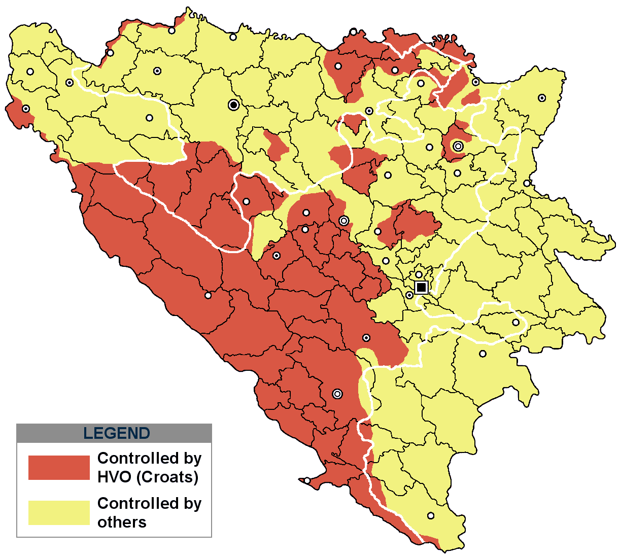
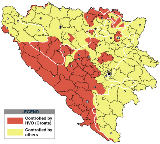
Miêu tả
(
| Miêu tả |
This is an update for the previous map, as the HVO never controlled all parts of municipality of Mostar and Stolac. Also, HVO never controlled neither part of municipalities Nevesinje, Berkovići, Ljubinje and Trebinje.
|
| Ngày | |
| Nguồn gốc | self-made by Nihad Hamzić |
| Tác giả | Nihad Hamzic |
}
Giấy phép
| Tác phẩm này đã được tác giả của nó, I, Nihad Hamzic, phát hành vào phạm vi công cộng. Điều này có hiệu lực trên toàn thế giới. Tại một quốc gia mà luật pháp không cho phép điều này, thì: I, Nihad Hamzic cho phép tất cả mọi người được quyền sử dụng tác phẩm này với bất cứ mục đích nào, không kèm theo bất kỳ điều kiện nào, trừ phi luật pháp yêu cầu những điều kiện đó. |
The original image is here:
http://commons.wikimedia.org/wiki/Image:Hvo_controled.GIF
Check its description for licensing etc.
Lịch sử tập tin
Nhấn vào ngày/giờ để xem nội dung tập tin tại thời điểm đó.
| Ngày/giờ | Hình xem trước | Kích cỡ | Thành viên | Miêu tả | |
|---|---|---|---|---|---|
| hiện tại | 17:21, ngày 29 tháng 11 năm 2020 | | 1.220×1.100 (99 kB) | Ceha | Tuzla i Bugojno |
| 13:31, ngày 28 tháng 11 năm 2020 |  | 1.220×1.100 (98 kB) | Ceha | Dodao neke promjene, od Ravne-Brčko, do Ravnog na jugu (operacija Bura https://hr.wikipedia.org/wiki/Operacija_Bura ) | |
| 17:40, ngày 20 tháng 7 năm 2011 |  | 1.220×1.100 (48 kB) | DIREKTOR | Colors | |
| 09:29, ngày 11 tháng 2 năm 2009 |  | 1.220×1.100 (49 kB) | Ceha | Corrected errors in Komušina municipality, HVO controled all of Croatian settlments till 10th of August 1991 | |
| 08:24, ngày 11 tháng 8 năm 2008 |  | 1.220×1.100 (49 kB) | Mostarac | {{Information |Description=This is an update for the previous map, as the HVO never controlled all parts of municipality of Mostar and Stolac. Also, HVO never controlled neither part of municipalities Nevesinje, Berkovići and Ljubinje. |Source=self-made | |
| 14:33, ngày 5 tháng 1 năm 2008 |  | 1.220×1.100 (49 kB) | Nihad Hamzic | Added a legend. Also widened the image slightly to match the size of related images. I did not resize it, but added white space at sides. | |
| 10:08, ngày 17 tháng 7 năm 2007 |  | 1.213×1.100 (41 kB) | Nihad Hamzic | Revised the colors to match (to be uniform) with colors in other related maps. | |
| 22:31, ngày 15 tháng 7 năm 2007 |  | 1.213×1.100 (41 kB) | Nihad Hamzic | {{Information |Description=BiH territories which were controlled by HVO and regular Croatian Army for some time during the war. <br /> <br /> NOTICE:<br /> This image is a greatly optimised PNG version of the original GIF version of the image. Color dihte |
Trang sử dụng tập tin
Sử dụng tập tin toàn cục
Những wiki sau đang sử dụng tập tin này:
- Trang sử dụng tại ar.wikipedia.org
- Trang sử dụng tại ast.wikipedia.org
- Trang sử dụng tại bs.wikipedia.org
- Trang sử dụng tại ca.wikipedia.org
- Trang sử dụng tại cs.wikipedia.org
- Trang sử dụng tại de.wikipedia.org
- Trang sử dụng tại es.wikipedia.org
- Trang sử dụng tại eu.wikipedia.org
- Trang sử dụng tại fr.wikipedia.org
- Trang sử dụng tại gl.wikipedia.org
- Trang sử dụng tại hy.wikipedia.org
- Trang sử dụng tại hyw.wikipedia.org
- Trang sử dụng tại it.wikipedia.org
- Trang sử dụng tại pnb.wikipedia.org
- Trang sử dụng tại pt.wikipedia.org
- Trang sử dụng tại ru.wikipedia.org
- Trang sử dụng tại sr.wikipedia.org
- Trang sử dụng tại sv.wikipedia.org