Tập tin:ISS-30 Lake Fitri, Chad.jpg
Kích thước hình xem trước: 800×531 điểm ảnh. Độ phân giải khác: 320×213 điểm ảnh | 640×425 điểm ảnh | 1.024×680 điểm ảnh | 1.280×850 điểm ảnh | 2.560×1.700 điểm ảnh | 4.288×2.848 điểm ảnh.
Tập tin gốc (4.288×2.848 điểm ảnh, kích thước tập tin: 6,37 MB, kiểu MIME: image/jpeg)
Tập tin này từ Wikimedia Commons. Trang miêu tả nó ở đấy được sao chép dưới đây. Commons là kho lưu trữ tập tin phương tiện có giấy phép tự do. Bạn có thể tham gia. |
Miêu tả
| Miêu tả |
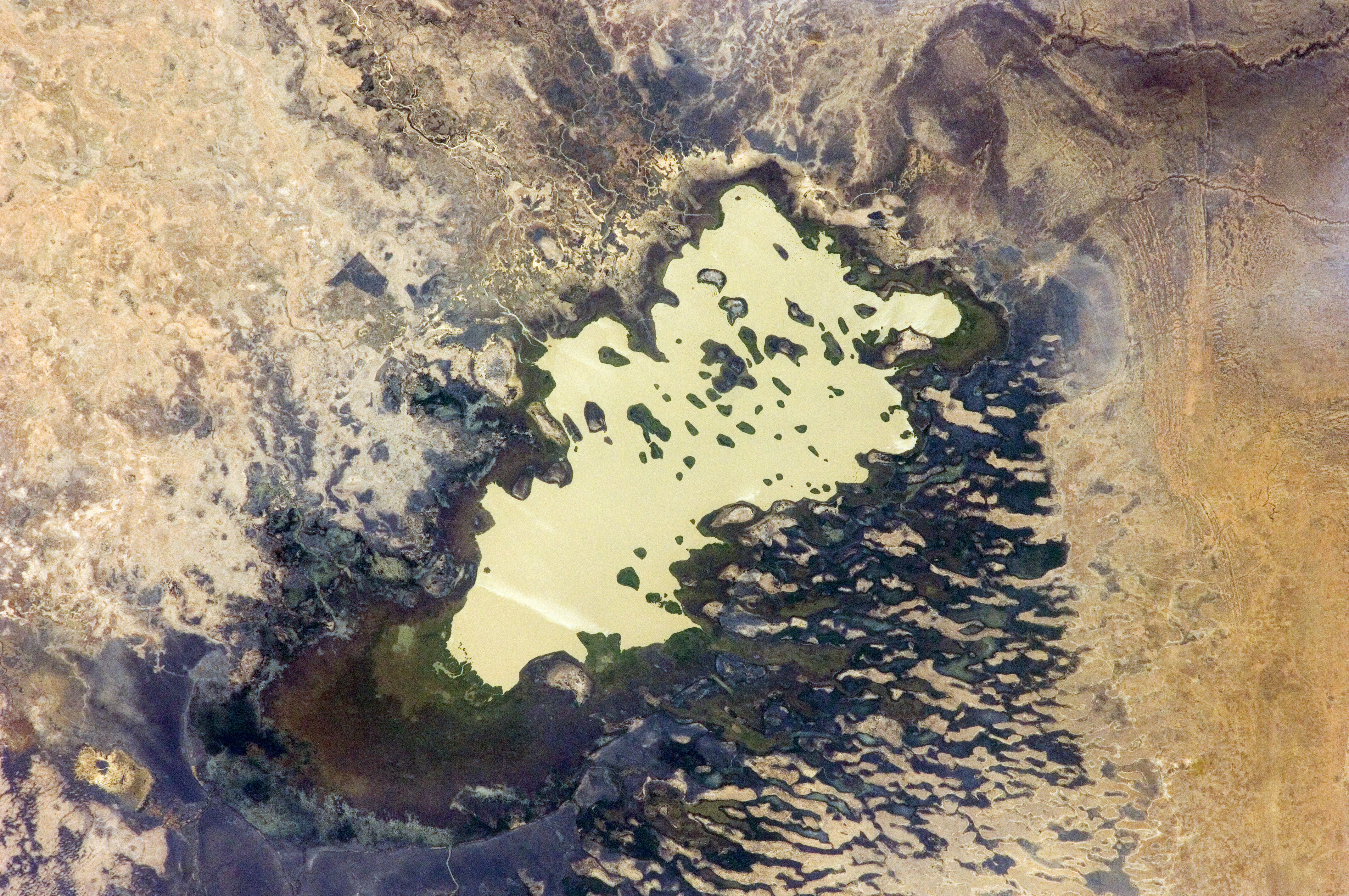
English: Lake Fitri, Chad is featured in this image photographed by an Expedition 30 crew member on the International Space Station.
|
| Ngày | |
| Nguồn gốc | http://spaceflight.nasa.gov/gallery/images/station/crew-30/html/iss030e059398.html |
| Tác giả | NASA |
This image or video was catalogued by Johnson Space Center of the United States National Aeronautics and Space Administration (NASA) under Photo ID: ISS030-E-059398. This tag does not indicate the copyright status of the attached work. A normal copyright tag is still required. See Commons:Licensing. Other languages:
|
Giấy phép
This file is in the public domain in the United States because it was created by the Image Science & Analysis Laboratory, of the NASA Johnson Space Center. NASA copyright policy states that "NASA material is not protected by copyright unless noted". (NASA media use guidelines or Conditions of Use of Astronaut Photographs).
Photo source: ISS030-E-59398.
|
Lịch sử tập tin
Nhấn vào ngày/giờ để xem nội dung tập tin tại thời điểm đó.
| Ngày/giờ | Hình xem trước | Kích cỡ | Thành viên | Miêu tả | |
|---|---|---|---|---|---|
| hiện tại | 20:00, ngày 20 tháng 4 năm 2016 | | 4.288×2.848 (6,37 MB) | Ras67 | new rendered in high quality from NASA's raw image data |
| 12:46, ngày 4 tháng 6 năm 2012 |  | 4.288×2.848 (2,03 MB) | Ras67 | levels | |
| 17:59, ngày 21 tháng 2 năm 2012 |  | 4.288×2.848 (1,76 MB) | Ras67 | {{Information |Description ={{en|1=Lake Fitri, Chad is featured in this image photographed by an Expedition 30 crew member on the International Space Station. Lake Fitri is an endorheic, or terminal lake in a desert basin in the southern Sahara Desert. |
Trang sử dụng tập tin
Có 1 trang tại Wikipedia tiếng Việt có liên kết đến tập tin (không hiển thị trang ở các dự án khác):
Sử dụng tập tin toàn cục
Những wiki sau đang sử dụng tập tin này:
- Trang sử dụng tại ar.wikipedia.org
- Trang sử dụng tại arz.wikipedia.org
- Trang sử dụng tại be.wikipedia.org
- Trang sử dụng tại cv.wikipedia.org
- Trang sử dụng tại de.wikipedia.org
- Trang sử dụng tại el.wikipedia.org
- Trang sử dụng tại en.wikipedia.org
- Trang sử dụng tại es.wikipedia.org
- Trang sử dụng tại fr.wikipedia.org
- Trang sử dụng tại id.wikipedia.org
- Trang sử dụng tại it.wikipedia.org
- Trang sử dụng tại ka.wikipedia.org
- Trang sử dụng tại lt.wikipedia.org
- Trang sử dụng tại my.wikipedia.org
- Trang sử dụng tại nl.wikipedia.org
- Trang sử dụng tại pl.wikipedia.org
- Trang sử dụng tại ru.wikipedia.org
- Trang sử dụng tại www.wikidata.org