Tập tin:ISS029-E-008032 Fires along the Rio Xingu - Brazil.jpg

Tập tin gốc (4.288×2.848 điểm ảnh, kích thước tập tin: 8,76 MB, kiểu MIME: image/jpeg)
Tập tin này từ Wikimedia Commons. Trang miêu tả nó ở đấy được sao chép dưới đây. Commons là kho lưu trữ tập tin phương tiện có giấy phép tự do. Bạn có thể tham gia. |
Miêu tả
| Miêu tả |
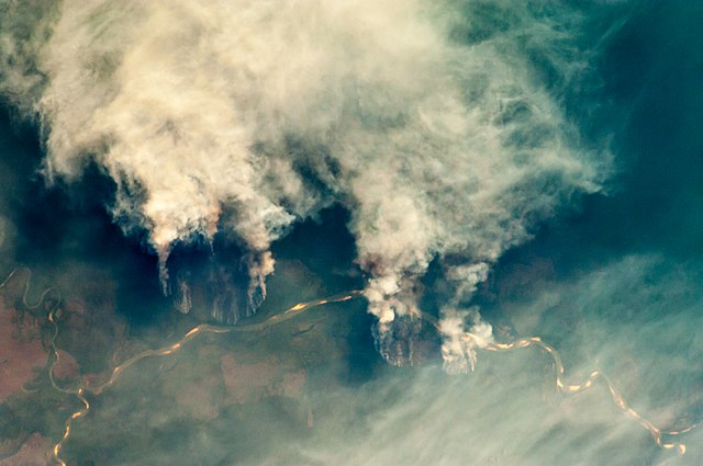
English: Slash-and-burn forest clearing along the Rio Xingu (Xingu River) in the state of Mato Grosso, Brazil.
|
||||||||||||||||||||||||||||||||||||||||||||||||||||||
| Ngày | |||||||||||||||||||||||||||||||||||||||||||||||||||||||
| Nguồn gốc | ISS029-E-8032 | ||||||||||||||||||||||||||||||||||||||||||||||||||||||
| Tác giả |
|
||||||||||||||||||||||||||||||||||||||||||||||||||||||
| Phiên bản khác |
|
||||||||||||||||||||||||||||||||||||||||||||||||||||||


This file is in the public domain in the United States because it was created by the Image Science & Analysis Laboratory, of the NASA Johnson Space Center. NASA copyright policy states that "NASA material is not protected by copyright unless noted". (NASA media use guidelines or Conditions of Use of Astronaut Photographs).
Photo source: ISS029-E-008032.
|
Giấy phép
| This file is in the public domain in the United States because it was solely created by NASA. NASA copyright policy states that "NASA material is not protected by copyright unless noted". (See Template:PD-USGov, NASA copyright policy page or JPL Image Use Policy.) | ||
 |
Warnings:
|
Lịch sử tập tin
Nhấn vào ngày/giờ để xem nội dung tập tin tại thời điểm đó.
| Ngày/giờ | Hình xem trước | Kích cỡ | Thành viên | Miêu tả | |
|---|---|---|---|---|---|
| hiện tại | 09:55, ngày 27 tháng 4 năm 2013 | | 4.288×2.848 (8,76 MB) | Julian Herzog | User created page with UploadWizard |
Trang sử dụng tập tin
Chưa có trang nào ở Wikipedia tiếng Việt liên kết đến tập tin này.
Sử dụng tập tin toàn cục
Những wiki sau đang sử dụng tập tin này:
- Trang sử dụng tại af.wikipedia.org
- Trang sử dụng tại ar.wikipedia.org
- Trang sử dụng tại cs.wikipedia.org
- Trang sử dụng tại dag.wikipedia.org
- Trang sử dụng tại de.wikipedia.org
- Trang sử dụng tại en.wikipedia.org
- Trang sử dụng tại ga.wikipedia.org
- Trang sử dụng tại ha.wikipedia.org
- Trang sử dụng tại ig.wikipedia.org
- Trang sử dụng tại ja.wikipedia.org
- Trang sử dụng tại ml.wikipedia.org
- Trang sử dụng tại mni.wikipedia.org
- Trang sử dụng tại mr.wikipedia.org
- Trang sử dụng tại ms.wikipedia.org
- Trang sử dụng tại pa.wikipedia.org
- Trang sử dụng tại shi.wikipedia.org
- Trang sử dụng tại simple.wikipedia.org
- Trang sử dụng tại sv.wikipedia.org
- Trang sử dụng tại zh.wikipedia.org