Tập tin:Japan Relief Map of Land and Seabed.png
Kích thước hình xem trước: 727×599 điểm ảnh. Độ phân giải khác: 291×240 điểm ảnh | 582×480 điểm ảnh | 932×768 điểm ảnh | 1.242×1.024 điểm ảnh | 2.117×1.745 điểm ảnh.
Tập tin gốc (2.117×1.745 điểm ảnh, kích thước tập tin: 7,47 MB, kiểu MIME: image/png)
Tập tin này từ Wikimedia Commons. Trang miêu tả nó ở đấy được sao chép dưới đây. Commons là kho lưu trữ tập tin phương tiện có giấy phép tự do. Bạn có thể tham gia. |
Miêu tả
| Miêu tả |
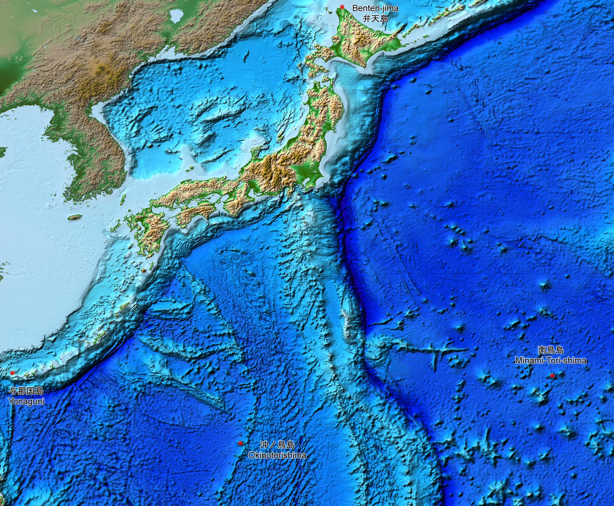
English: This is a relief map of the land and the seabed of Japan. It shows the surface and underwater terrain of the Japanese archipelago. It includes all the Japanese islands such as Minami-Tori-Shima, Benten-jima, Okinotorishima and Yonaguni.
日本語: 日本近海海底地形図と日本列島。 |
| Ngày | |
| Nguồn gốc | ETOPO1, Global Relief Model, https://www.ngdc.noaa.gov/mgg/global/global.html |
| Tác giả | NASA, National Geophysical Data Center, NOAA |
Giấy phép
| This file is in the public domain in the United States because it was solely created by NASA. NASA copyright policy states that "NASA material is not protected by copyright unless noted". (See Template:PD-USGov, NASA copyright policy page or JPL Image Use Policy.) | ||
 |
Warnings:
|
Lịch sử tập tin
Nhấn vào ngày/giờ để xem nội dung tập tin tại thời điểm đó.
| Ngày/giờ | Hình xem trước | Kích cỡ | Thành viên | Miêu tả | |
|---|---|---|---|---|---|
| hiện tại | 15:07, ngày 5 tháng 8 năm 2019 | | 2.117×1.745 (7,47 MB) | Artanisen | The continent geography is darker to highlight the Japanese archipelago. |
| 06:29, ngày 22 tháng 7 năm 2019 |  | 2.117×1.745 (7,54 MB) | Artanisen | User created page with UploadWizard |
Trang sử dụng tập tin
Có 1 trang tại Wikipedia tiếng Việt có liên kết đến tập tin (không hiển thị trang ở các dự án khác):
Sử dụng tập tin toàn cục
Những wiki sau đang sử dụng tập tin này:
- Trang sử dụng tại ar.wikipedia.org
- Trang sử dụng tại ast.wikipedia.org
- Trang sử dụng tại be.wikipedia.org
- Trang sử dụng tại ca.wikipedia.org
- Trang sử dụng tại de.wikipedia.org
- Trang sử dụng tại en.wikipedia.org
- Trang sử dụng tại es.wikipedia.org
- Trang sử dụng tại fr.wikipedia.org
- Trang sử dụng tại id.wikipedia.org
- Trang sử dụng tại it.wikipedia.org
- Trang sử dụng tại ja.wikipedia.org
- Trang sử dụng tại min.wikipedia.org
- Trang sử dụng tại pnb.wikipedia.org
- Trang sử dụng tại pt.wikipedia.org
- Trang sử dụng tại ru.wikipedia.org
- Trang sử dụng tại sl.wikipedia.org
- Trang sử dụng tại sr.wikipedia.org
- Trang sử dụng tại tl.wikipedia.org
- Trang sử dụng tại uk.wikipedia.org
- Trang sử dụng tại www.wikidata.org
- Trang sử dụng tại zh-min-nan.wikipedia.org
- Trang sử dụng tại zh.wikipedia.org