Tập tin:Late October 2021 nor'easter 2021-10-27 1743Z.jpg

Kích thước hình xem trước: 456×600 điểm ảnh. Độ phân giải khác: 182×240 điểm ảnh | 365×480 điểm ảnh | 584×768 điểm ảnh | 778×1.024 điểm ảnh | 1.556×2.048 điểm ảnh | 3.800×5.000 điểm ảnh.
Tập tin gốc (3.800×5.000 điểm ảnh, kích thước tập tin: 4,3 MB, kiểu MIME: image/jpeg)
Tập tin này từ Wikimedia Commons. Trang miêu tả nó ở đấy được sao chép dưới đây. Commons là kho lưu trữ tập tin phương tiện có giấy phép tự do. Bạn có thể tham gia. |
Miêu tả
| Miêu tả |
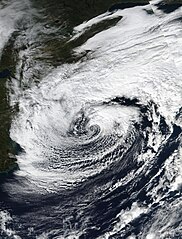
English: Taken from the VIIRS instrument on the Suomi-NPP satellite, this true color image of a Nor'easter was taken on October 27, 2021 at 17:43 (UTC) 1:43 PM (Local Time). When this image was taken the Nor'easter was coming off its peak earlier in the day at 09:00 (UTC) 5:00 AM (Local Time). Throughout the days of October 26 and October 27 this Nor'easter brought flooding and high-winds along the I-95 Corridor from about Washington DC up to Boston, this nor'easter would also become Tropical Storm Wanda in the Far North Atlantic on October 31. The estimated intensity of the Nor'easter at the time this image was taken was 65 MPH (55 KNOTS or 105 KMH) with a minimum central pressure of 980 Millibars (hPa). |
| Ngày | |
| Nguồn gốc | https://worldview.earthdata.nasa.gov/ |
| Tác giả | NASA/Suomi-NPP |
| Phiên bản khác |
|

| Vị trí máy chụp hình | | Xem hình này và các hình ảnh lân cận trên: OpenStreetMap |
|---|
Giấy phép
| This file is in the public domain in the United States because it was solely created by NASA. NASA copyright policy states that "NASA material is not protected by copyright unless noted". (See Template:PD-USGov, NASA copyright policy page or JPL Image Use Policy.) | ||
 |
Warnings:
|
Lịch sử tập tin
Nhấn vào ngày/giờ để xem nội dung tập tin tại thời điểm đó.
| Ngày/giờ | Hình xem trước | Kích cỡ | Thành viên | Miêu tả | |
|---|---|---|---|---|---|
| hiện tại | 20:34, ngày 7 tháng 11 năm 2021 | | 3.800×5.000 (4,3 MB) | Hurricaneboy23 | Tweaks to levels |
| 16:18, ngày 5 tháng 11 năm 2021 |  | 3.800×5.000 (4,13 MB) | TheWxResearcher | Closer to a 3:4 Ratio | |
| 15:46, ngày 5 tháng 11 năm 2021 |  | 4.000×5.000 (2,93 MB) | TheWxResearcher | Uploaded a work by NASA/Suomi-NPP from https://worldview.earthdata.nasa.gov/ with UploadWizard |
Trang sử dụng tập tin
Có 2 trang tại Wikipedia tiếng Việt có liên kết đến tập tin (không hiển thị trang ở các dự án khác):
Sử dụng tập tin toàn cục
Những wiki sau đang sử dụng tập tin này:
- Trang sử dụng tại en.wikipedia.org
- Trang sử dụng tại fa.wikipedia.org
- Trang sử dụng tại pa.wikipedia.org
- Trang sử dụng tại pt.wikipedia.org
- Trang sử dụng tại shn.wikipedia.org
- Trang sử dụng tại simple.wikipedia.org