Tập tin:Liverpool Bay.png

Kích thước hình xem trước: 800×593 điểm ảnh. Độ phân giải khác: 320×237 điểm ảnh | 640×474 điểm ảnh | 1.024×759 điểm ảnh | 1.278×947 điểm ảnh.
Tập tin gốc (1.278×947 điểm ảnh, kích thước tập tin: 1,84 MB, kiểu MIME: image/png)
Tập tin này từ Wikimedia Commons. Trang miêu tả nó ở đấy được sao chép dưới đây. Commons là kho lưu trữ tập tin phương tiện có giấy phép tự do. Bạn có thể tham gia. |
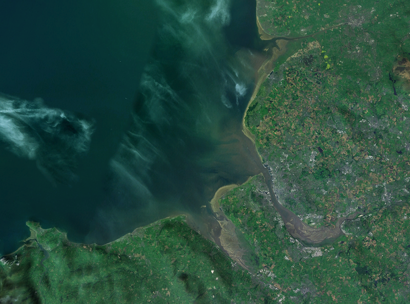
| Miêu tả | A satellite photograph of Liverpool Bay, showing the West Lancashire Coastal Plain River Ribble at the top (north), the River Alt (hardly visble), River Mersey (centre) River Dee and the River Conwy in the south west. |
| Ngày | |
| Nguồn gốc | NASA World Wind - Landsat 7 |
| Tác giả | Smurrayinchester |
| This image is in the public domain because it is a screenshot from NASA’s globe software World Wind using a public domain layer, such as Blue Marble, MODIS, Landsat, SRTM, USGS or GLOBE.
|
 |
| Vị trí máy chụp hình | | Xem hình này và các hình ảnh lân cận trên: OpenStreetMap |
|---|

Lịch sử tập tin
Nhấn vào ngày/giờ để xem nội dung tập tin tại thời điểm đó.
| Ngày/giờ | Hình xem trước | Kích cỡ | Thành viên | Miêu tả | |
|---|---|---|---|---|---|
| hiện tại | 14:06, ngày 28 tháng 4 năm 2007 | | 1.278×947 (1,84 MB) | Smurrayinchester | {{Information |Description=A satellite photograph of w:Liverpool Bay, showing the Rivers Dee and Mersey (centre), the River Alt (north) and the River Conwy (west). |Source=NASA World Wind - Landsat 7 |Date=28 April 2007 |Author= [[User:Smurrayincheste |
Trang sử dụng tập tin
Có 1 trang tại Wikipedia tiếng Việt có liên kết đến tập tin (không hiển thị trang ở các dự án khác):
Sử dụng tập tin toàn cục
Những wiki sau đang sử dụng tập tin này:
- Trang sử dụng tại ca.wikipedia.org
- Trang sử dụng tại ceb.wikipedia.org
- Trang sử dụng tại cy.wikipedia.org
- Trang sử dụng tại en.wikipedia.org
- Trang sử dụng tại eo.wikipedia.org
- Trang sử dụng tại es.wikipedia.org
- Trang sử dụng tại et.wikipedia.org
- Trang sử dụng tại it.wikipedia.org
- Trang sử dụng tại nl.wikipedia.org
- Trang sử dụng tại nn.wikipedia.org
- Trang sử dụng tại no.wikipedia.org
- Trang sử dụng tại pl.wikipedia.org
- Trang sử dụng tại pl.wiktionary.org
- Trang sử dụng tại ru.wikipedia.org
- Trang sử dụng tại sr.wikipedia.org
- Trang sử dụng tại sv.wikipedia.org
- Trang sử dụng tại www.wikidata.org