Tập tin:Map of England 1086.png
Kích thước hình xem trước: 479×599 điểm ảnh. Độ phân giải khác: 192×240 điểm ảnh | 384×480 điểm ảnh | 614×768 điểm ảnh | 818×1.024 điểm ảnh | 2.398×3.000 điểm ảnh.
Tập tin gốc (2.398×3.000 điểm ảnh, kích thước tập tin: 1,43 MB, kiểu MIME: image/png)
Tập tin này từ Wikimedia Commons. Trang miêu tả nó ở đấy được sao chép dưới đây. Commons là kho lưu trữ tập tin phương tiện có giấy phép tự do. Bạn có thể tham gia. |

|
Hình ảnh thuộc thể loại "map" cần được vẽ lại bằng đồ họa vector theo định dạng tập tin SVG. Để biết ưu điểm của định dạng này, hãy đọc Commons:Media for cleanup. Nếu tập tin này đã có SVG, xin hãy tải lên đây rồi thay bản mẫu này bằng {{vector version available|tên hình mới.svg}}.
|
Miêu tả
| Miêu tả |
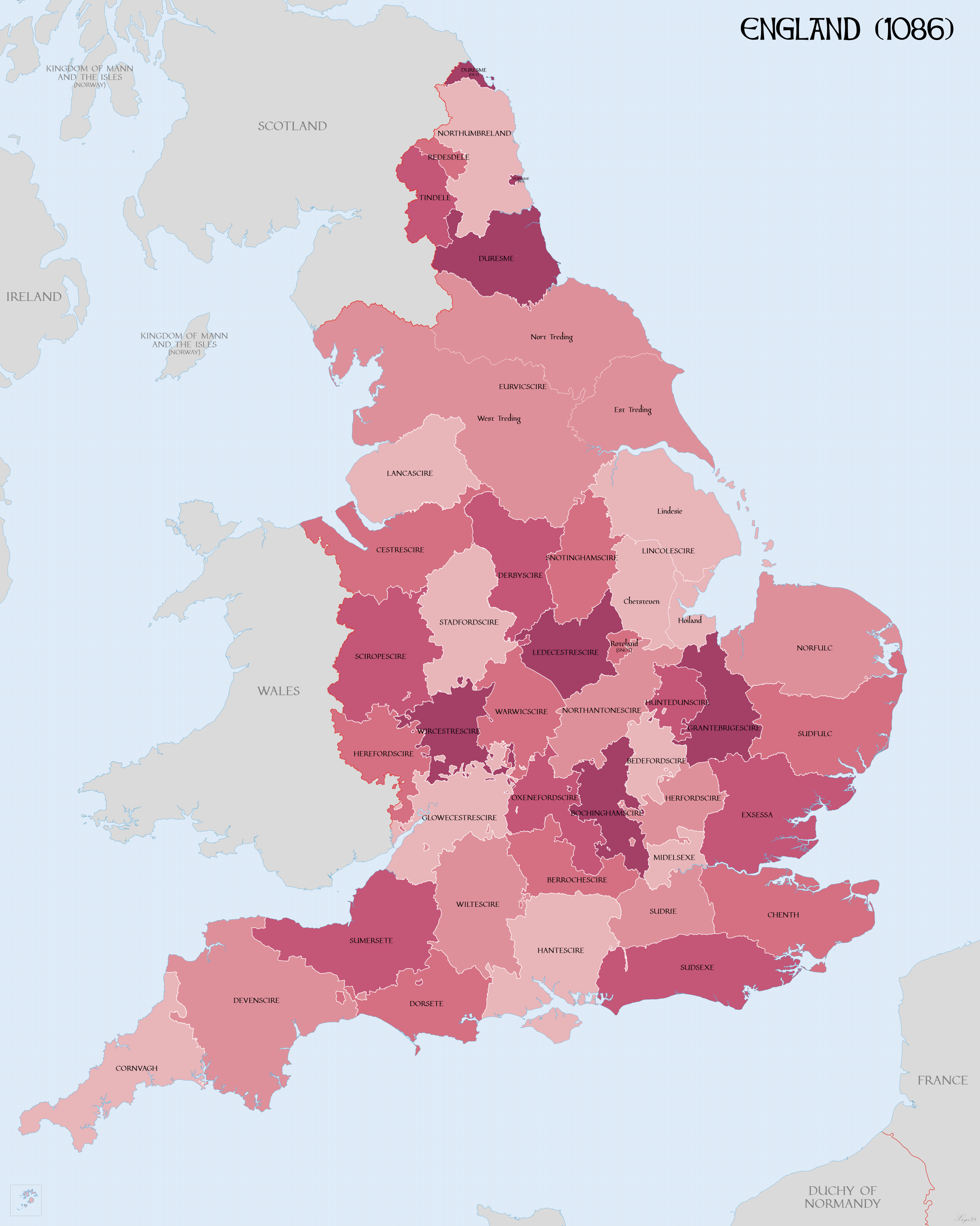
English: Map of English Counties in 1086. |
| Ngày | |
| Nguồn gốc |
Own work using:
|
| Tác giả | XrysD |
| Phiên bản khác | Derivative works of this file: DomesdayCountyCircuitsMap.png |
Giấy phép
Tôi, người giữ bản quyền tác phẩm này, từ đây phát hành nó theo giấy phép sau:
Tập tin này được phát hành theo Giấy phép Creative Commons Ghi công–Chia sẻ tương tự 4.0 Quốc tế.
- Bạn được phép:
- chia sẻ – sao chép, phân phối và chuyển giao tác phẩm
- pha trộn – để chuyển thể tác phẩm
- Theo các điều kiện sau:
- ghi công – Bạn phải ghi lại tác giả và nguồn, liên kết đến giấy phép, và các thay đổi đã được thực hiện, nếu có. Bạn có thể làm các điều trên bằng bất kỳ cách hợp lý nào, miễn sao không ám chỉ rằng người cho giấy phép ủng hộ bạn hay việc sử dụng của bạn.
- chia sẻ tương tự – Nếu bạn biến tấu, biến đổi, hoặc làm tác phẩm khác dựa trên tác phẩm này, bạn chỉ được phép phân phối tác phẩm mới theo giấy phép y hệt hoặc tương thích với tác phẩm gốc.
Lịch sử tập tin
Nhấn vào ngày/giờ để xem nội dung tập tin tại thời điểm đó.
| Ngày/giờ | Hình xem trước | Kích cỡ | Thành viên | Miêu tả | |
|---|---|---|---|---|---|
| hiện tại | 10:58, ngày 15 tháng 4 năm 2018 | | 2.398×3.000 (1,43 MB) | XrysD | Increased line widths to improve clarity |
| 17:43, ngày 14 tháng 4 năm 2018 |  | 2.398×3.000 (1,41 MB) | XrysD | Coastline modifcations: Lincolnshire and the Wash in accordance with "LINCOLNSHIRE COASTAL VILLAGES AND THE SEA c.1300 - c.1600: ECONOMY AND SOCIETY" Pawley (1984). Sussex: Pevensey Bay in accordance with http://saxonhistory.co.uk/. Kent: Cinque Ports area in accordance with http://www.historyfiles.co.uk/KingListsBritain/EnglandKent_Oxney01_Full.htm and http://villagenet.co.uk/history/1155-cinqueports.php. Euruicscire changed to Eurvicscire. Durham exclaves changed just to reference Durham. | |
| 09:49, ngày 18 tháng 3 năm 2018 |  | 2.398×3.000 (1,46 MB) | XrysD | Added: Ridings of Yorkshire; Parts of Lincolnshire; Rutland as detached part of Notts; Norhamshire, Hexhamshire and Bedlingtonshire as parts of Durham. | |
| 18:26, ngày 12 tháng 3 năm 2018 |  | 2.398×3.000 (1,45 MB) | XrysD | Changed county names uncial font to more legible version | |
| 20:59, ngày 11 tháng 3 năm 2018 |  | 2.398×3.000 (1,16 MB) | XrysD | User created page with UploadWizard |
Trang sử dụng tập tin
Có 1 trang tại Wikipedia tiếng Việt có liên kết đến tập tin (không hiển thị trang ở các dự án khác):
Sử dụng tập tin toàn cục
Những wiki sau đang sử dụng tập tin này:
- Trang sử dụng tại cs.wikipedia.org
- Trang sử dụng tại de.wikipedia.org
- Trang sử dụng tại en.wikipedia.org
- Trang sử dụng tại hr.wikipedia.org
- Trang sử dụng tại it.wikipedia.org
- Trang sử dụng tại ja.wikipedia.org
- Trang sử dụng tại sk.wikipedia.org