Tập tin:Maria, Bopha and Saomai 2006-08-07 0435Z.jpg

Tập tin gốc (7.200×9.000 điểm ảnh, kích thước tập tin: 7,6 MB, kiểu MIME: image/jpeg)
Tập tin này từ Wikimedia Commons. Trang miêu tả nó ở đấy được sao chép dưới đây. Commons là kho lưu trữ tập tin phương tiện có giấy phép tự do. Bạn có thể tham gia. |
| Cảnh báo | Một số trình duyệt có thể gặp trở ngại trong việc hiển thị hình này ở cỡ đầy đủ. Hình này có một số lượng điểm ảnh lớn và có thể không được tải chính xác hoặc làm trình duyệt bị treo. |
|---|
Miêu tả
| Miêu tả |
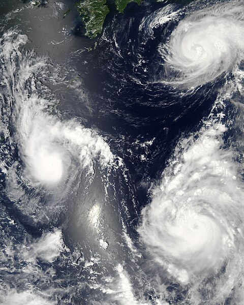
Three different typhoons were spinning over the western Pacific Ocean on August 7, 2006, when the Moderate Resolution Imaging Spectroradiometer (MODIS) on NASA’s Aqua satellite acquired this image. The strongest of the three, Typhoon Saomai, formed in the western Pacific on August 4, 2006, as a tropical depression. Within a day, it had become organized enough to be classified as a tropical storm. While Saomai was strengthening into a storm, another tropical depression formed a few hundred kilometers to the north, and by August 6, it became tropical storm Maria. Typhoon Bopha formed just as Maria reached storm status and became a storm itself on August 7. As of August 7, the University of Hawaii’s Tropical Storm Information Center predicted that Bopha and Saomai would continue on tracks that would take each into China, while Maria would move northwest across the southern end of Japan. Saomai was predicted to gather strength, while Maria and Bopha were projected to remain near their current strengths. This image was acquired at 12:35 p.m. local time (04:35 UTC) on August 7. It is unusual, but certainly not unprecedented, to have three storm systems all in the same general area at one time. The trio makes an interesting illustration of the evolution of tropical storm systems. Bopha, the youngest at just a few hours old, shows only the most basic round shape of a tropical storm. Maria, a day older, shows more distinct spiral structure with arms and an apparent central eye. Despite their differences in appearance, both storms were around the same size and strength, with peak sustained winds of around 90 and 100 kilometers per hour (58 and 63 miles per hour), respectively. A day older than Maria is the much more powerful Typhoon Saomai. At the time of this image, the typhoon had sustained winds of around 140 km/hr (85 mph), and forecasters predicted that it would continue to gather strength before coming ashore in China, according to the University of Hawaii’s Tropical Storm Information Center. The typhoon’s well-developed structure (including a distinct, closed eye in the center) in comparison to Maria is clear in this image. The slanting diagonal feature through the image is sunlight bouncing off the ocean into the MODIS instrument, a phenomenon called sunglint. The very bright patch is where the reflection is strongest. |
|||||
| Ngày | ||||||
| Nguồn gốc | http://earthobservatory.nasa.gov/NaturalHazards/natural_hazards_v2.php3?img_id=13754 | |||||
| Tác giả | NASA image by Jeff Schmaltz, MODIS Rapid Response Team, Goddard Space Flight Center. | |||||
| Giấy phép (Dùng lại tập tin) |
|
|||||
| Phiên bản khác |


| Annotations | This image is annotated: View the annotations at Commons |
Lịch sử tập tin
Nhấn vào ngày/giờ để xem nội dung tập tin tại thời điểm đó.
| Ngày/giờ | Hình xem trước | Kích cỡ | Thành viên | Miêu tả | |
|---|---|---|---|---|---|
| hiện tại | 03:06, ngày 8 tháng 8 năm 2006 | | 7.200×9.000 (7,6 MB) | Good kitty | == Summary == {{Information |Description=Three different typhoons were spinning over the western Pacific Ocean on August 7, 2006, when the Moderate Resolution Imaging Spectroradiometer (MODIS) on NASA’s Aqua satellite acquired this image. The strongest |
Trang sử dụng tập tin
Sử dụng tập tin toàn cục
Những wiki sau đang sử dụng tập tin này:
- Trang sử dụng tại ar.wikipedia.org
- Trang sử dụng tại az.wikipedia.org
- Trang sử dụng tại bg.wikipedia.org
- Trang sử dụng tại bh.wikipedia.org
- Trang sử dụng tại crh.wikipedia.org
- Trang sử dụng tại cs.wikipedia.org
- Trang sử dụng tại de.wikipedia.org
- Trang sử dụng tại en.wikipedia.org
- Typhoon
- Typhoon Saomai
- Tropical cyclone
- Wikipedia:Picture peer review/Archives/Archive2006
- User:Plasticup/MyFavorites
- Typhoon Maria (2006)
- User talk:Hurricanehink/Archive 23
- User talk:Thegreatdr/2012archive
- Wikipedia:Wikipedia Signpost/2013-11-20/Traffic report
- Wikipedia:Wikipedia Signpost/Single/2013-11-20
- Wikipedia:Top 25 Report/November 10 to 16, 2013
- User:Tfmbty/2006 Pacific typhoon season
- User:SongdaTalas/Archives of Former Articles
- Trang sử dụng tại en.wiktionary.org
- Trang sử dụng tại es.wikipedia.org
- Trang sử dụng tại fi.wikipedia.org
- Trang sử dụng tại hi.wikipedia.org
- Trang sử dụng tại id.wiktionary.org
- Trang sử dụng tại incubator.wikimedia.org
- Trang sử dụng tại ja.wikipedia.org
- Trang sử dụng tại ja.wikibooks.org
- Trang sử dụng tại ko.wikipedia.org
- Trang sử dụng tại lo.wikipedia.org
- Trang sử dụng tại ms.wikipedia.org
- Trang sử dụng tại my.wikipedia.org
- Trang sử dụng tại nn.wikipedia.org
- Trang sử dụng tại no.wikipedia.org
- Trang sử dụng tại pt.wikipedia.org
- Trang sử dụng tại ro.wikipedia.org
- Trang sử dụng tại ru.wikipedia.org
- Trang sử dụng tại szy.wikipedia.org
- Trang sử dụng tại th.wikipedia.org
- Trang sử dụng tại tk.wikipedia.org
Xem thêm các trang toàn cục sử dụng tập tin này.