Tập tin:Maricopa County Incorporated and Planning areas Glendale highlighted.svg

Kích thước bản xem trước PNG này của tập tin SVG: 694×599 điểm ảnh. Độ phân giải khác: 278×240 điểm ảnh | 556×480 điểm ảnh | 889×768 điểm ảnh | 1.185×1.024 điểm ảnh | 2.371×2.048 điểm ảnh | 940×812 điểm ảnh.
Tập tin gốc (tập tin SVG, 940×812 điểm ảnh trên danh nghĩa, kích thước: 1,05 MB)
Tập tin này từ Wikimedia Commons. Trang miêu tả nó ở đấy được sao chép dưới đây. Commons là kho lưu trữ tập tin phương tiện có giấy phép tự do. Bạn có thể tham gia. |
Miêu tả
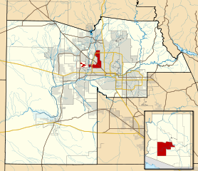
| Miêu tả | This map shows the incorporated areas and Indian reservation boundaries in Maricopa County, Arizona, along with water bodies and major highways and roads. Glendale is highlighted in red. Other incorporated cities are shown in gray, planning area borders for these cities and Indian reservation borders are shown as solid black lines. Changes from Previous Version: Updated the maps to include water bodies and to make "less boring" than the plain black/white/gray maps. Format was updated to match standards laid out by WikiProject Maps/Conventions. Map data is based on data from the following Webpage: Maricopa County Interactive GIS Map. I created this map in Inkscape. |
| Ngày | |
| Nguồn gốc | My own work, based on government information |
| Tác giả | Ixnayonthetimmay |
| Giấy phép (Dùng lại tập tin) |
Public Domain |
| Phiên bản khác | See Category:Maps of Maricopa County for other versions of this image. |
Giấy phép
| Tôi, người giữ bản quyền của tác phẩm này, chuyển tác phẩm này vào phạm vi công cộng. Điều này có giá trị trên toàn thế giới. Tại một quốc gia mà luật pháp không cho phép điều này, thì: Tôi cho phép tất cả mọi người được quyền sử dụng tác phẩm này với bất cứ mục đích nào, không kèm theo bất kỳ điều kiện nào, trừ phi luật pháp yêu cầu những điều kiện đó. |
Lịch sử tập tin
Nhấn vào ngày/giờ để xem nội dung tập tin tại thời điểm đó.
| Ngày/giờ | Hình xem trước | Kích cỡ | Thành viên | Miêu tả | |
|---|---|---|---|---|---|
| hiện tại | 06:32, ngày 20 tháng 5 năm 2011 | | 940×812 (1,05 MB) | Ixnayonthetimmay | Uploading new version |
| 04:10, ngày 30 tháng 8 năm 2008 |  | 900×800 (423 kB) | Ixnayonthetimmay | == Summary == {{Information |Description=This map shows the incorporated areas and unincorporated areas in Maricopa County, Arizona. [[:en:Glendale, Arizona| | |
| 00:16, ngày 16 tháng 9 năm 2007 |  | 900×800 (384 kB) | Ixnayonthetimmay | {{Information |Description= |Source= |Date= |Author= |Permission= |other_versions= }} | |
| 10:00, ngày 28 tháng 5 năm 2007 |  | 900×780 (329 kB) | Ixnayonthetimmay | ||
| 00:07, ngày 22 tháng 5 năm 2007 |  | 900×780 (318 kB) | Ixnayonthetimmay | ||
| 05:05, ngày 30 tháng 1 năm 2007 |  | 904×758 (189 kB) | Ixnayonthetimmay | {{Information |Description=This map shows the incorporated areas in Maricopa County, Arizona, highlighting Glendale in red. It also shows the boundaries for the |
Trang sử dụng tập tin
Có 1 trang tại Wikipedia tiếng Việt có liên kết đến tập tin (không hiển thị trang ở các dự án khác):
Sử dụng tập tin toàn cục
Những wiki sau đang sử dụng tập tin này:
- Trang sử dụng tại ar.wikipedia.org
- Trang sử dụng tại arz.wikipedia.org
- Trang sử dụng tại br.wikipedia.org
- Trang sử dụng tại ca.wikipedia.org
- Trang sử dụng tại ceb.wikipedia.org
- Trang sử dụng tại de.wikipedia.org
- Trang sử dụng tại el.wikipedia.org
- Trang sử dụng tại eo.wikipedia.org
- Trang sử dụng tại es.wikipedia.org
- Trang sử dụng tại eu.wikipedia.org
- Trang sử dụng tại fa.wikipedia.org
- Trang sử dụng tại fi.wikipedia.org
- Trang sử dụng tại fr.wikipedia.org
- Trang sử dụng tại ga.wikipedia.org
- Trang sử dụng tại gl.wikipedia.org
- Trang sử dụng tại hr.wikipedia.org
- Trang sử dụng tại ht.wikipedia.org
- Trang sử dụng tại hu.wikipedia.org
- Trang sử dụng tại id.wikipedia.org
- Trang sử dụng tại ja.wikipedia.org
- Trang sử dụng tại kw.wikipedia.org
- Trang sử dụng tại mrj.wikipedia.org
- Trang sử dụng tại ms.wikipedia.org
- Trang sử dụng tại pt.wikipedia.org
- Trang sử dụng tại ro.wikipedia.org
- Trang sử dụng tại sco.wikipedia.org
- Trang sử dụng tại sr.wikipedia.org
- Trang sử dụng tại sw.wikipedia.org
- Trang sử dụng tại ta.wikipedia.org
- Trang sử dụng tại tr.wikipedia.org
- Trang sử dụng tại tt.wikipedia.org
- Trang sử dụng tại ur.wikipedia.org
- Trang sử dụng tại vo.wikipedia.org
- Trang sử dụng tại www.wikidata.org