Tập tin:MarsTopoMap-PIA02031 modest.jpg

Kích thước hình xem trước: 674×600 điểm ảnh. Độ phân giải khác: 270×240 điểm ảnh | 540×480 điểm ảnh | 864×768 điểm ảnh | 1.151×1.024 điểm ảnh | 2.497×2.221 điểm ảnh.
Tập tin gốc (2.497×2.221 điểm ảnh, kích thước tập tin: 1,09 MB, kiểu MIME: image/jpeg)
Tập tin này từ Wikimedia Commons. Trang miêu tả nó ở đấy được sao chép dưới đây. Commons là kho lưu trữ tập tin phương tiện có giấy phép tự do. Bạn có thể tham gia. |
Miêu tả


| Miêu tả |
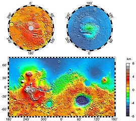
English: Maps of Mars' global topography. The projections are Mercator to 70° latitude and stereographic at the poles with the south pole at left and north pole at right. Note the elevation difference between the northern and southern hemispheres. The Tharsis volcano-tectonic province is centered near the equator in the longitude range 220° E to 300° E and contains the vast east-west trending Valles Marineris canyon system and several major volcanic shields including Olympus Mons (18° N, 225° E), Alba Patera (42° N, 252° E), Ascraeus Mons (12° N, 248° E), Pavonis Mons (0°, 247° E), and Arsia Mons (9° S, 239° E). Regions and structures discussed in the text include Solis Planum (25° S, 270° E), Lunae Planum (10° N, 290° E), and Claritas Fossae (30° S, 255° E). Major impact basins include Hellas (45° S, 70° E), Argyre (50° S, 320° E), Isidis (12° N, 88° E), and Utopia (45° N, 110° E). This analysis uses an areocentric coordinate convention with east longitude positive.
Русский: Топографическая карта Марса. |
| Ngày | |
| Nguồn gốc |
http://photojournal.jpl.nasa.gov/jpeg/PIA02031.jpg
|
| Tác giả | NASA/JPL-Caltech/GSFC |
| Giấy phép (Dùng lại tập tin) |
PD-USGOV-NASA |
This image or video was catalogued by Jet Propulsion Laboratory of the United States National Aeronautics and Space Administration (NASA) under Photo ID: PIA02031. This tag does not indicate the copyright status of the attached work. A normal copyright tag is still required. See Commons:Licensing. Other languages:
|
Giấy phép
| This file is in the public domain in the United States because it was solely created by NASA. NASA copyright policy states that "NASA material is not protected by copyright unless noted". (See Template:PD-USGov, NASA copyright policy page or JPL Image Use Policy.) | ||
 |
Warnings:
|
Nhật trình tải lên đầu tiên
Trang miêu tả gốc từng tồn tại ở đây. Tất cả các tên người dùng sau là tên người dùng tại en.wikipedia.
- 2004-05-06 16:52 Wwoods 612×545×8 (88223 bytes) Topographic Map of Mars; http://photojournal.jpl.nasa.gov/catalog/PIA02031 ; {{msg:PD}}
| Annotations | This image is annotated: View the annotations at Commons |


Lịch sử tập tin
Nhấn vào ngày/giờ để xem nội dung tập tin tại thời điểm đó.
| Ngày/giờ | Hình xem trước | Kích cỡ | Thành viên | Miêu tả | |
|---|---|---|---|---|---|
| hiện tại | 00:43, ngày 22 tháng 3 năm 2005 | | 2.497×2.221 (1,09 MB) | Wikibob~commonswiki | high res jpg from http://photojournal.jpl.nasa.gov/jpeg/PIA02031.jpg PD |
| 16:40, ngày 30 tháng 12 năm 2004 |  | 612×545 (86 kB) | Kristaga | NASA-photo, all NASA images are free to use. |
Trang sử dụng tập tin
Có 2 trang tại Wikipedia tiếng Việt có liên kết đến tập tin (không hiển thị trang ở các dự án khác):
Sử dụng tập tin toàn cục
Những wiki sau đang sử dụng tập tin này:
- Trang sử dụng tại als.wikipedia.org
- Trang sử dụng tại ar.wikipedia.org
- Trang sử dụng tại be.wikipedia.org
- Trang sử dụng tại bg.wikipedia.org
- Trang sử dụng tại bo.wikipedia.org
- Trang sử dụng tại ca.wikipedia.org
- Trang sử dụng tại ca.wikibooks.org
- Trang sử dụng tại cv.wikipedia.org
- Trang sử dụng tại de.wikipedia.org
- Trang sử dụng tại el.wikipedia.org
- Trang sử dụng tại en.wikipedia.org
- User:Mcdavis941/mars
- Wikipedia:Reference desk/Science/Archive
- User:Scholar743/subpage3
- Mars ocean theory
- Phaethontis quadrangle
- Water on Mars
- Ptolemaeus (Martian crater)
- Tader Valles
- Gorgonum Chaos
- Wikipedia:Reference desk/Archives/Science/2010 September 26
- User talk:Wikileadspresident
- List of largest craters in the Solar System
- User:Jimmarsmars/sandbox
- Lakes on Mars
- Trang sử dụng tại en.wikiversity.org
- Trang sử dụng tại es.wikipedia.org
- Trang sử dụng tại eu.wikipedia.org
- Trang sử dụng tại fa.wikipedia.org
- Trang sử dụng tại fi.wikipedia.org
- Trang sử dụng tại fr.wikipedia.org
- Trang sử dụng tại gl.wikipedia.org
- Trang sử dụng tại he.wikipedia.org
- Trang sử dụng tại hi.wikipedia.org
- Trang sử dụng tại hr.wikipedia.org
- Trang sử dụng tại hu.wikipedia.org
Xem thêm các trang toàn cục sử dụng tập tin này.