Tập tin:Melia azedarach (429546268).jpg

Tập tin gốc (2.816×2.112 điểm ảnh, kích thước tập tin: 2,45 MB, kiểu MIME: image/jpeg)
Tập tin này từ Wikimedia Commons. Trang miêu tả nó ở đấy được sao chép dưới đây. Commons là kho lưu trữ tập tin phương tiện có giấy phép tự do. Bạn có thể tham gia. |
.jpg?uselang=vi)
Miêu tả
| Miêu tả |
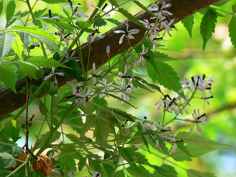
Common name: Chinaberry tree, Persian lilac, Pride of India, Bead tree, Lilac tree, Bakain बकैन (Hindi), Seizrak (Manipuri), Bakan-nimb बकाणनिंब (Marathi), Bakarjam (Bengali), Kattu vembhu காட்டு வேம்பூ (Tamil) Botanical name: Melia azedarach (ME-lee-uh) from the Greek name for Ash; (az-ee-duh-rak) from the Persian words meaning noble tree Synonyms: Melia australis, Melia japonica, Melia sempervivens, Melia azedarach var. umbraculifera Family: Meliaceae (melia, or mahogany family) - [ (me-lee-AY-see-ay) the Melia family (from the Greek name for Ash) due to the similarity of the leaves ] Origin: India The lovely Bead Tree is somewhat similar to the Nim in appearance and takes the place of that tree in the Northern parts of India. Both have compound leaves with narrow, serrate-edged leaflets terminating in long points but those of the Bead Tree are smaller, lack the sythe-like curve and are subdivided at the base into several pinnae bearing five or seven leaflets. The Bead Tree is indigenous to parts of N. India and Burma and is now cultivated in all the sub-tropical regions of the world. Melia is the Greek name of the Ash, but is not very appropriate as there is only superficial resemblance between the Bead tree and the Ash. Azedarach is from the Persian azad-darakht. It is a medium-sized tree, fast-growing and attaining up to 40 feet in height in a few years, but its beauty is short-lived; at the age of about 20 years it commences to die off. The bark is dark grey-brown cracked vertically by long furrows. Courtesy: - Flowers of India - TopTropicals - Dave's Garden - Zipcode Zoo Note: Information has not been verified and may not be reliable; please check for any inaccuracy. |
| Ngày | |
| Nguồn gốc | Melia azedarach |
| Tác giả | Dinesh Valke from Thane, India |
| Vị trí máy chụp hình | | Xem hình này và các hình ảnh lân cận trên: OpenStreetMap |
|---|
.jpg¶ms=019.119553_N_0072.874717_E_globe:Earth_type:camera_source:Flickr_&language=vi)
Giấy phép
- Bạn được phép:
- chia sẻ – sao chép, phân phối và chuyển giao tác phẩm
- pha trộn – để chuyển thể tác phẩm
- Theo các điều kiện sau:
- ghi công – Bạn phải ghi lại tác giả và nguồn, liên kết đến giấy phép, và các thay đổi đã được thực hiện, nếu có. Bạn có thể làm các điều trên bằng bất kỳ cách hợp lý nào, miễn sao không ám chỉ rằng người cho giấy phép ủng hộ bạn hay việc sử dụng của bạn.
- chia sẻ tương tự – Nếu bạn biến tấu, biến đổi, hoặc làm tác phẩm khác dựa trên tác phẩm này, bạn chỉ được phép phân phối tác phẩm mới theo giấy phép y hệt hoặc tương thích với tác phẩm gốc.
| Hình này, ban đầu được tải lên tại Flickr bởi dinesh_valke vào https://flickr.com/photos/91314344@N00/429546268. Tập tin đã được FlickreviewR kiểm tra vào 21 tháng 9 năm 2016 và xác nhận rằng nó tuân theo các điều khoản của cc-by-sa-2.0. |
Lịch sử tập tin
Nhấn vào ngày/giờ để xem nội dung tập tin tại thời điểm đó.
| Ngày/giờ | Hình xem trước | Kích cỡ | Thành viên | Miêu tả | |
|---|---|---|---|---|---|
| hiện tại | 06:41, ngày 21 tháng 9 năm 2016 | | 2.816×2.112 (2,45 MB) | Sreejithk2000 | Transferred from Flickr via Flickr2Commons |
.jpg)