Tập tin:Norderney Landsat7.png

Kích thước hình xem trước: 800×278 điểm ảnh. Độ phân giải khác: 320×111 điểm ảnh | 1.152×400 điểm ảnh.
Tập tin gốc (1.152×400 điểm ảnh, kích thước tập tin: 522 kB, kiểu MIME: image/png)
Tập tin này từ Wikimedia Commons. Trang miêu tả nó ở đấy được sao chép dưới đây. Commons là kho lưu trữ tập tin phương tiện có giấy phép tự do. Bạn có thể tham gia. |
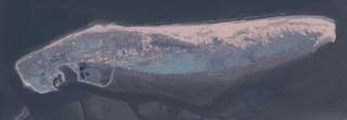
Miêu tả
Deutsch: Aufnahme der deutschen Insel Norderney durch Community Landsat 7.
English: Picture of german island Norderney taken by Community Landsat 7.
Source: NASA World Wind, originally uploaded to de:Bild:Landsat7ney.png by de:Benutzer:Elvaube: 17:47, 21. Jul 2005 . . Elvaube . . 1152 x 400 (534483 Byte) (Beschreibung: Community Landsat 7 Aufnahme von Norderney Quelle: NASA World Wind Lizenz: public domain)
Giấy phép
| This image is in the public domain because it is a screenshot from NASA’s globe software World Wind using a public domain layer, such as Blue Marble, MODIS, Landsat, SRTM, USGS or GLOBE.
|
 |
Lịch sử tập tin
Nhấn vào ngày/giờ để xem nội dung tập tin tại thời điểm đó.
| Ngày/giờ | Hình xem trước | Kích cỡ | Thành viên | Miêu tả | |
|---|---|---|---|---|---|
| hiện tại | 19:42, ngày 29 tháng 12 năm 2005 | 1.152×400 (522 kB) | Dabbelju | ==Description== {{de|Aufnahme der deutschen Insel Norderney durch Community Landsat 7.}} {{en|Picture of german island Norderney taken by Community Landsat 7.}} '''Source:''' NASA World Wind, originally uploaded to de:Bild:Landsat7ney.png b |
Trang sử dụng tập tin
Có 1 trang tại Wikipedia tiếng Việt có liên kết đến tập tin (không hiển thị trang ở các dự án khác):
Sử dụng tập tin toàn cục
Những wiki sau đang sử dụng tập tin này:
- Trang sử dụng tại cs.wikipedia.org
- Trang sử dụng tại de.wikipedia.org
- Trang sử dụng tại eo.wikipedia.org
- Trang sử dụng tại fy.wikipedia.org
- Trang sử dụng tại hy.wikipedia.org
- Trang sử dụng tại nn.wikipedia.org
- Trang sử dụng tại simple.wikipedia.org