Tập tin:PIA13708westernrimgeo.jpg

Tập tin gốc (4.023×7.854 điểm ảnh, kích thước tập tin: 4,23 MB, kiểu MIME: image/jpeg)
Tập tin này từ Wikimedia Commons. Trang miêu tả nó ở đấy được sao chép dưới đây. Commons là kho lưu trữ tập tin phương tiện có giấy phép tự do. Bạn có thể tham gia. |

|
Tập tin này được dời đến Wikimedia Commons từ en.wikipedia sử dụng một nguyên bản của bot. Tất cả các nguồn thông tin vẫn còn tồn tại. Cần có một sự xem xét lại. Ngoài ra, có thể có lỗi ở một vài hoặc tất cả các miền thông tin; thông tin trên tập tin này có thể không xác thực và tập tin này không nên được sử dụng cho đến khi nó được xem xét lại và những chỉnh sửa cần thiết được thực hiện. Một khi tập tin đã được xem xét xong, bản mẫu này nên được dời đi. Chi tiết về tập tin này, xin xem bên dưới. |
Miêu tả
| Miêu tả |
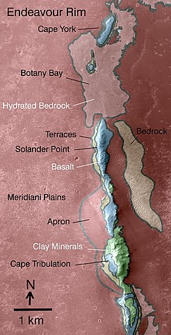
English: This map indicates some of the geological information gained from orbital observations of Endeavour Crater, which has been the long-term destination for NASA's Mars Exploration Rover Opportunity since mid-2008.
Endeavour Crater is about 22 kilometers (14 miles) in diameter. As indicated by the scale bar of one kilometer (0.6 mile), this map covers only a small portion of the crater's western rim. A discontinuous ridge runs north-south, exposing basalt (coded blue) and clay minerals (coded green) believed to be from a time in Martian history before the deposition of sulfates on the portions of the Meridiani Plains region that Opportunity has seen during the rover's first seven years on Mars. The rover team plans to begin Opportunity's exploration of the Endeavour rim near "Cape York," which is about 6.5 kilometers (4 miles) from the rover's location in mid-December 2010. Cape York is nearly surrounded by exposures of hydrated bedrock. From there, the planned exploration route goes south along the rim fragment "Solander Point," to "Cape Tribulation," where clay minerals have been detected. This geological map is based on observations by the Compact Reconnaissance Imaging Spectrometer for Mars (CRISM) on NASA's Mars Reconnaissance Orbiter. |
| Ngày | |
| Nguồn gốc | https://photojournal.jpl.nasa.gov/catalog/PIA13708 |
| Tác giả | NASA/JPL-Caltech/JHUAPL |
Giấy phép
| This file is in the public domain in the United States because it was solely created by NASA. NASA copyright policy states that "NASA material is not protected by copyright unless noted". (See Template:PD-USGov, NASA copyright policy page or JPL Image Use Policy.) | ||
 |
Warnings:
|
Nhật trình tải lên đầu tiên
| Ngày/Giờ | Kích cỡ | Thành viên | Miêu tả |
|---|---|---|---|
| 2016-10-12 17:10 | 4023×7854× (4431187 bytes) | Fotaun | {{PD-NASA}} http://photojournal.jpl.nasa.gov/jpeg/PIA13708.jpg http://www.jpl.nasa.gov/spaceimages/details.php?id=PIA13708 his map indicates some of the geological information gained from orbital observations of Endeavour Crater, which has been the l... |
Lịch sử tập tin
Nhấn vào ngày/giờ để xem nội dung tập tin tại thời điểm đó.
| Ngày/giờ | Hình xem trước | Kích cỡ | Thành viên | Miêu tả | |
|---|---|---|---|---|---|
| hiện tại | 05:25, ngày 19 tháng 8 năm 2018 | | 4.023×7.854 (4,23 MB) | JCPagc2015 | Transferred from en.wikipedia via #commonshelper |
Trang sử dụng tập tin
Chưa có trang nào ở Wikipedia tiếng Việt liên kết đến tập tin này.
Sử dụng tập tin toàn cục
Những wiki sau đang sử dụng tập tin này:
- Trang sử dụng tại en.wikipedia.org
- Trang sử dụng tại es.wikipedia.org