Tập tin:PIA16150 fig1-Mars Curiosity Rover-Glenelg Terrain.jpg

Tập tin gốc (1.280×781 điểm ảnh, kích thước tập tin: 704 kB, kiểu MIME: image/jpeg)
Tập tin này từ Wikimedia Commons. Trang miêu tả nó ở đấy được sao chép dưới đây. Commons là kho lưu trữ tập tin phương tiện có giấy phép tự do. Bạn có thể tham gia. |
Miêu tả
| Miêu tả |
English: 09.19.2012
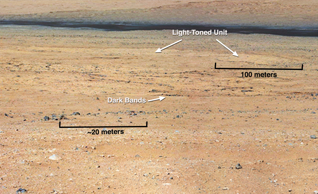
Dark Bands Run Through Light Layers (Annotated) This mosaic from the Mast Camera on NASA's Curiosity rover shows a close-up view looking toward the "Glenelg" area, where three different terrain types come together. All three types are observed from orbit with the High-Resolution Imaging Science Experiment (HiRISE) camera on NASA's Mars Reconnaissance Orbiter. By driving there, Curiosity will be able to explore them. One of these terrain types is light-toned with well-developed layering, which likely records the deposition of sedimentary materials. There are also black bands that run through the area and might constitute additional layers that alternate with the light-toned layer(s). The black bands are not easily seen from orbit and are on the order of about 3.3-feet (1-meter) thick. Both of these layer types are important science targets. This mosaic is composed of images taken with the Mastcam 100-millimeter camera.Polski: Ciemne pasma przebiegające wzdłuż jasnych warstw Ta mozaika zdjęć wykonanych przez jedną z kamer masztowych należącego do NASA łazika Curiosity pokazuje zbliżenie terenu, patrząc w stronę obszaru "Glenelg", w którym spotykają się trzy różne typy terenu. Wszystkie trzy typy terenu są obserwowane z orbity przez teleskop HiRISE zamontowany na orbiterze Mars Reconnaissance Orbiter. Kiedy Curiosity dojedzie do obszaru Glenelg będzie prowadzić eksploracje tego obszaru. Jednym z trzech typów jest teren jasno stonowany, z dobrze rozwiniętą strukturą warstw, który prawdopodobnie zawiera nagromadzone materiały osadowe. Istnieją także ciemne pasy, przebiegające przez obszar Glenelg i mogą stanowić dodatkowe warstwy, przeplatane z warstwami jasnymi. Ciemne pasy nie są łatwo widoczne z orbity i są rzędu około 1 metra grubości. Oba typy tych warstw są związane z ważnymi oczekiwaniami naukowców względem badań planowanych na tym obszarze. Mozaika ta, składa się ze zdjęć wykonanych przez jedną z dwu kamer masztowych ang. MastCam, kamerą 100-milimetrową. Zdjęcie posiada polskie adnotacje. Kliknij aby je uruchomić Image Credit: NASA/JPL-Caltech/MSSS |
| Ngày | |
| Nguồn gốc | http://photojournal.jpl.nasa.gov/figures/PIA16150_fig1.jpg |
| Tác giả | NASA/JPL-Caltech/MSSS |
| Phiên bản khác | http://photojournal.jpl.nasa.gov/catalog/PIA16150 |
Giấy phép
| This file is in the public domain in the United States because it was solely created by NASA. NASA copyright policy states that "NASA material is not protected by copyright unless noted". (See Template:PD-USGov, NASA copyright policy page or JPL Image Use Policy.) | ||
 |
Warnings:
|
| Annotations | This image is annotated: View the annotations at Commons |
Lịch sử tập tin
Nhấn vào ngày/giờ để xem nội dung tập tin tại thời điểm đó.
| Ngày/giờ | Hình xem trước | Kích cỡ | Thành viên | Miêu tả | |
|---|---|---|---|---|---|
| hiện tại | 11:51, ngày 20 tháng 9 năm 2012 | | 1.280×781 (704 kB) | Drbogdan | User created page with UploadWizard |
Trang sử dụng tập tin
Sử dụng tập tin toàn cục
Những wiki sau đang sử dụng tập tin này:
- Trang sử dụng tại en.wikipedia.org
- Trang sử dụng tại es.wikipedia.org
- Trang sử dụng tại lb.wikipedia.org
- Trang sử dụng tại pl.wikipedia.org
- Trang sử dụng tại ru.wikipedia.org
- Trang sử dụng tại zh.wikipedia.org