Tập tin:PIA16550-MarsCuriosityRover-ShalerOutcrop-20121207.jpg

Tập tin gốc (2.438×1.141 điểm ảnh, kích thước tập tin: 470 kB, kiểu MIME: image/jpeg)
Tập tin này từ Wikimedia Commons. Trang miêu tả nó ở đấy được sao chép dưới đây. Commons là kho lưu trữ tập tin phương tiện có giấy phép tự do. Bạn có thể tham gia. |
Miêu tả
| Miêu tả |
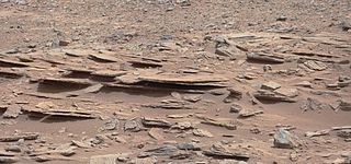
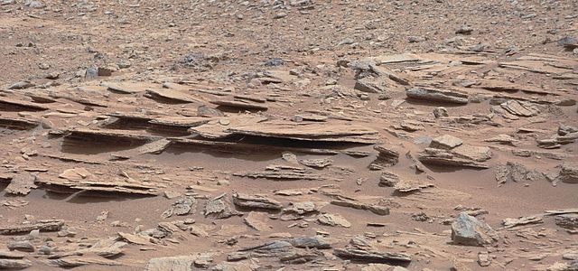
English: PIA16550: Layered Martian Outcrop 'Shaler' in 'Glenelg' Area
http://photojournal.jpl.nasa.gov/catalog/PIA16550 Target Name: Mars Is a satellite of: Sol (our sun) Mission: Mars Science Laboratory (MSL) Spacecraft: Mars Science Laboratory (MSL) Instrument: Mastcam Product Size: 2438 x 1141 pixels (width x height) Produced By: Malin Space Science Systems Full-Res TIFF: PIA16550.tif (8.349 MB) Full-Res JPEG: PIA16550.jpg (481.8 kB) Click on the image above to download a moderately sized image in JPEG format (possibly reduced in size from original) Original Caption Released with Image: Figure 1 Figure 2 Click on an individual image for larger views The NASA Mars rover Curiosity used its Mast Camera (Mastcam) during the mission's 120th Martian day, or sol (Dec. 7, 2012), to record this view of a rock outcrop informally named "Shaler." The outcrop's striking layers, some at angles to each other in a pattern called crossbedding, made it a target of interest for the mission's science team. The site is near where three types of terrain meet at a place called "Glenelg," inside Gale Crater. The area covered by the image spans about 3 feet (90 centimeters) in the foreground. Figure 1 includes a 10-centimeter (4-inch) scale bar. The image has been white-balanced to show what the rock would look like if it were on Earth. Figure 2 is a raw-color version, showing what the rock looks like on Mars to the camera. Malin Space Science Systems, San Diego, developed, built and operates Mastcam. JPL, a division of the California Institute of Technology, Pasadena, manages the Mars Science Laboratory Project for NASA's Science Mission Directorate, Washington. JPL designed and built the project's Curiosity rover. For more about NASA's Curiosity mission, visit: http://www.jpl.nasa.gov/msl, http://www.nasa.gov/mars, and http://mars.jpl.nasa.gov/msl. Polski: Należący do NASA łazik Curiosity użył kamery umieszczonej na maszcie (Mastcam), podczas 120 dnia marsjańskiego, albo Sol 120 (07 grudnia 2012), aby zarejestrować obraz wychodni skalnej nieformalnie nazwanej "Shaler". Przedmiotem zainteresowania misji zespołu naukowego jest fakt, że na wychodni warstw, z których niektóre z nich, są ustawione pod kątem względem siebie w szyku zwanym crossbedding. Miejsce jest w pobliżu punktu, gdzie trzy rodzaje terenu zbierają się w miejscu o nazwie "Glenelg" wewnątrz krateru Gale
Obszar objęty obrazem na pierwszym planie rozciąga się na około 90 cm. Obraz miał tak zbalansowaną biel, aby pokazać skały tak, jak by wyglądały w warunkach oświetlenia ziemskiego. .Image Credit: NASA/JPL-Caltech/MSSS Image Addition Date: 2012-12-11 |
| Ngày | |
| Nguồn gốc | http://photojournal.jpl.nasa.gov/jpeg/PIA16550.jpg |
| Tác giả | NASA/JPL-Caltech/MSSS |
Giấy phép
| This file is in the public domain in the United States because it was solely created by NASA. NASA copyright policy states that "NASA material is not protected by copyright unless noted". (See Template:PD-USGov, NASA copyright policy page or JPL Image Use Policy.) | ||
 |
Warnings:
|
Lịch sử tập tin
Nhấn vào ngày/giờ để xem nội dung tập tin tại thời điểm đó.
| Ngày/giờ | Hình xem trước | Kích cỡ | Thành viên | Miêu tả | |
|---|---|---|---|---|---|
| hiện tại | 04:05, ngày 12 tháng 12 năm 2012 | | 2.438×1.141 (470 kB) | Drbogdan | User created page with UploadWizard |
Trang sử dụng tập tin
Sử dụng tập tin toàn cục
Những wiki sau đang sử dụng tập tin này:
- Trang sử dụng tại en.wikipedia.org
- Trang sử dụng tại en.wikiversity.org
- Trang sử dụng tại es.wikipedia.org
- Trang sử dụng tại ga.wikipedia.org
- Trang sử dụng tại lb.wikipedia.org
- Trang sử dụng tại pl.wikipedia.org
- Trang sử dụng tại ru.wikipedia.org
- Trang sử dụng tại sk.wikipedia.org
- Trang sử dụng tại uk.wikipedia.org
- Trang sử dụng tại zh.wikipedia.org