Tập tin:Panampangan Island.jpg

Kích thước hình xem trước: 799×599 điểm ảnh. Độ phân giải khác: 320×240 điểm ảnh | 640×480 điểm ảnh | 1.024×768 điểm ảnh | 1.280×960 điểm ảnh | 2.560×1.920 điểm ảnh | 3.973×2.980 điểm ảnh.
Tập tin gốc (3.973×2.980 điểm ảnh, kích thước tập tin: 1,33 MB, kiểu MIME: image/jpeg)
Tập tin này từ Wikimedia Commons. Trang miêu tả nó ở đấy được sao chép dưới đây. Commons là kho lưu trữ tập tin phương tiện có giấy phép tự do. Bạn có thể tham gia. |
Miêu tả
| Miêu tả |
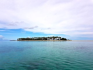
English: Panampangan island is located at the Basibuli Reef and possesses longest sandbar in the Philippines at the province of Tawi-Tawi. This was taken using the joint mapping, reconnaissance, and deployment mission of the Philippine Marine Corps and Schadow1 Expeditions |
||
| Ngày | |||
| Nguồn gốc | Tác phẩm được tạo bởi người tải lên | ||
| Tác giả | Ervin Malicdem | ||
| Giấy phép (Dùng lại tập tin) |
Tập tin này được phát hành theo Giấy phép Creative Commons Ghi công–Chia sẻ tương tự 4.0 Quốc tế.
|

| Vị trí máy chụp hình | | Xem hình này và các hình ảnh lân cận trên: OpenStreetMap |
|---|
Initially published at Schadow1 Expeditions article available at http://www.s1expeditions.com/2017/06/217-panampangan-islandtawi-tawi.html
Lịch sử tập tin
Nhấn vào ngày/giờ để xem nội dung tập tin tại thời điểm đó.
| Ngày/giờ | Hình xem trước | Kích cỡ | Thành viên | Miêu tả | |
|---|---|---|---|---|---|
| hiện tại | 07:11, ngày 15 tháng 9 năm 2017 | | 3.973×2.980 (1,33 MB) | Schadow1 | User created page with UploadWizard |
Trang sử dụng tập tin
Có 1 trang tại Wikipedia tiếng Việt có liên kết đến tập tin (không hiển thị trang ở các dự án khác):
Sử dụng tập tin toàn cục
Những wiki sau đang sử dụng tập tin này:
- Trang sử dụng tại be.wikipedia.org
- Trang sử dụng tại bjn.wikipedia.org
- Trang sử dụng tại bn.wikipedia.org
- Trang sử dụng tại ceb.wikipedia.org
- Trang sử dụng tại en.wikipedia.org
- Trang sử dụng tại fa.wikipedia.org
- Trang sử dụng tại hr.wikipedia.org
- Trang sử dụng tại id.wikipedia.org
- Trang sử dụng tại ilo.wikipedia.org
- Trang sử dụng tại mk.wikipedia.org
- Trang sử dụng tại ms.wikipedia.org
- Trang sử dụng tại simple.wikipedia.org
- Trang sử dụng tại th.wikipedia.org
- Trang sử dụng tại tl.wikipedia.org
- Trang sử dụng tại www.wikidata.org
- Trang sử dụng tại zh.wikipedia.org