Tập tin:Paraná River Floodplain.jpg
Không có độ phân giải cao hơn.
Paraná_River_Floodplain.jpg (720×480 điểm ảnh, kích thước tập tin: 179 kB, kiểu MIME: image/jpeg)
Tập tin này từ Wikimedia Commons. Trang miêu tả nó ở đấy được sao chép dưới đây. Commons là kho lưu trữ tập tin phương tiện có giấy phép tự do. Bạn có thể tham gia. |
| Miêu tả |
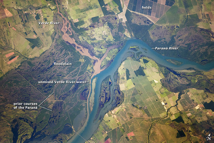
English: Paraná River Floodplain, Brazil
The Paraná River appears as a wide, blue strip with the muddy brown water of the smaller Verde River entering from the northwest (top left). An extensive wetland (dark green) occupies most of the left half of this astronaut photograph, and the floodplain reaches a width of 11 kilometers (about 7 miles). The thin line of a road crossing the floodplain also gives a sense of scale. Above the Paraná-Verde confluence (image center), the floodplain is much narrower. |
|||||
| Ngày | acquired on February 5, 2012 | |||||
| Nguồn gốc | http://earthobservatory.nasa.gov/IOTD/view.php?id=77444&src=eoa-iotd | |||||
| Tác giả | NASA Astronaut photograph ISS030-E-90012 | |||||
| Giấy phép (Dùng lại tập tin) |
|
|||||
| Phiên bản khác | See [4] for a larger version |

![[4]](http://eoimages.gsfc.nasa.gov/images/imagerecords/77000/77444/ISS030-E-090012_lrg.jpg)
Lịch sử tập tin
Nhấn vào ngày/giờ để xem nội dung tập tin tại thời điểm đó.
| Ngày/giờ | Hình xem trước | Kích cỡ | Thành viên | Miêu tả | |
|---|---|---|---|---|---|
| hiện tại | 18:28, ngày 22 tháng 3 năm 2012 | | 720×480 (179 kB) | Tillman | {{Information |Description ={{en|1=Paraná River Floodplain, Brazil The Paraná River appears as a wide, blue strip with the muddy brown water of the smaller Verde River entering from the northwest (top left). An extensive wetland (dark green) occu... |
Trang sử dụng tập tin
Có 1 trang tại Wikipedia tiếng Việt có liên kết đến tập tin (không hiển thị trang ở các dự án khác):
Sử dụng tập tin toàn cục
Những wiki sau đang sử dụng tập tin này:
- Trang sử dụng tại ba.wikipedia.org
- Trang sử dụng tại bh.wikipedia.org
- Trang sử dụng tại bn.wikipedia.org
- Trang sử dụng tại ca.wikipedia.org
- Trang sử dụng tại din.wikipedia.org
- Trang sử dụng tại en.wikipedia.org
- Trang sử dụng tại eo.wikipedia.org
- Trang sử dụng tại fi.wikipedia.org
- Trang sử dụng tại ja.wikipedia.org
- Trang sử dụng tại sl.wikipedia.org
- Trang sử dụng tại sr.wikipedia.org
- Trang sử dụng tại uk.wikipedia.org
- Trang sử dụng tại war.wikipedia.org
- Trang sử dụng tại www.wikidata.org
- Trang sử dụng tại zh.wikipedia.org