Tập tin:SafsafOasis SAR comparison.jpg
Không có độ phân giải cao hơn.
SafsafOasis_SAR_comparison.jpg (540×588 điểm ảnh, kích thước tập tin: 154 kB, kiểu MIME: image/jpeg)
Tập tin này từ Wikimedia Commons. Trang miêu tả nó ở đấy được sao chép dưới đây. Commons là kho lưu trữ tập tin phương tiện có giấy phép tự do. Bạn có thể tham gia. |
Miêu tả
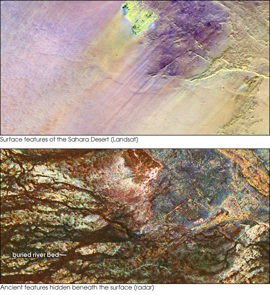
| Miêu tả | Two images of the Safsaf Oasis in The Sahara. The top image (taken by the Landat Thematic Mapper) is the surface. The bottom (taken by the Spaceborne Imaging Radar-C/X-band Synthetic Aperture Radar (SIR-C/X-SAR) on board the Space Shuttle Endeavour on April 16, 1994) is the rock layer underneath, revealing black channels cut by the meandering of an ancient river. |
| Ngày | not specified |
| Nguồn gốc | http://earthobservatory.nasa.gov/Newsroom/NewImages/images.php3?img_id=16963 |
| Tác giả | NASA/JPL Imaging Radar team. |
| Giấy phép (Dùng lại tập tin) |
Public domain |
| Phiên bản khác |
|


Giấy phép
| This file is in the public domain in the United States because it was solely created by NASA. NASA copyright policy states that "NASA material is not protected by copyright unless noted". (See Template:PD-USGov, NASA copyright policy page or JPL Image Use Policy.) | ||
 |
Warnings:
|
Lịch sử tập tin
Nhấn vào ngày/giờ để xem nội dung tập tin tại thời điểm đó.
| Ngày/giờ | Hình xem trước | Kích cỡ | Thành viên | Miêu tả | |
|---|---|---|---|---|---|
| hiện tại | 15:55, ngày 9 tháng 5 năm 2006 | | 540×588 (154 kB) | Holly Cheng | {{Information | Description=Two images of the Safsaf Oasis in the Sahara. The top image (taken by the Landat Thematic Mapper) is the surface. The bottom (taken by the Spaceborne Imaging Radar-C/X-band Synthetic Aperture Radar (SIR-C/X-SAR) on board the Sp |
Trang sử dụng tập tin
Có 1 trang tại Wikipedia tiếng Việt có liên kết đến tập tin (không hiển thị trang ở các dự án khác):
Sử dụng tập tin toàn cục
Những wiki sau đang sử dụng tập tin này:
- Trang sử dụng tại es.wikipedia.org
- Trang sử dụng tại eu.wikipedia.org
- Trang sử dụng tại la.wikipedia.org
- Trang sử dụng tại nds-nl.wikipedia.org
- Trang sử dụng tại rw.wikipedia.org
- Trang sử dụng tại sw.wikipedia.org
- Trang sử dụng tại zh-yue.wikipedia.org