Tập tin:Satellite image of South Island New Zealand.jpg
Kích thước hình xem trước: 487×599 điểm ảnh. Độ phân giải khác: 195×240 điểm ảnh | 390×480 điểm ảnh | 624×768 điểm ảnh | 832×1.024 điểm ảnh | 1.664×2.048 điểm ảnh | 2.600×3.200 điểm ảnh.
Tập tin gốc (2.600×3.200 điểm ảnh, kích thước tập tin: 2,08 MB, kiểu MIME: image/jpeg)
Tập tin này từ Wikimedia Commons. Trang miêu tả nó ở đấy được sao chép dưới đây. Commons là kho lưu trữ tập tin phương tiện có giấy phép tự do. Bạn có thể tham gia. |
| Miêu tả |
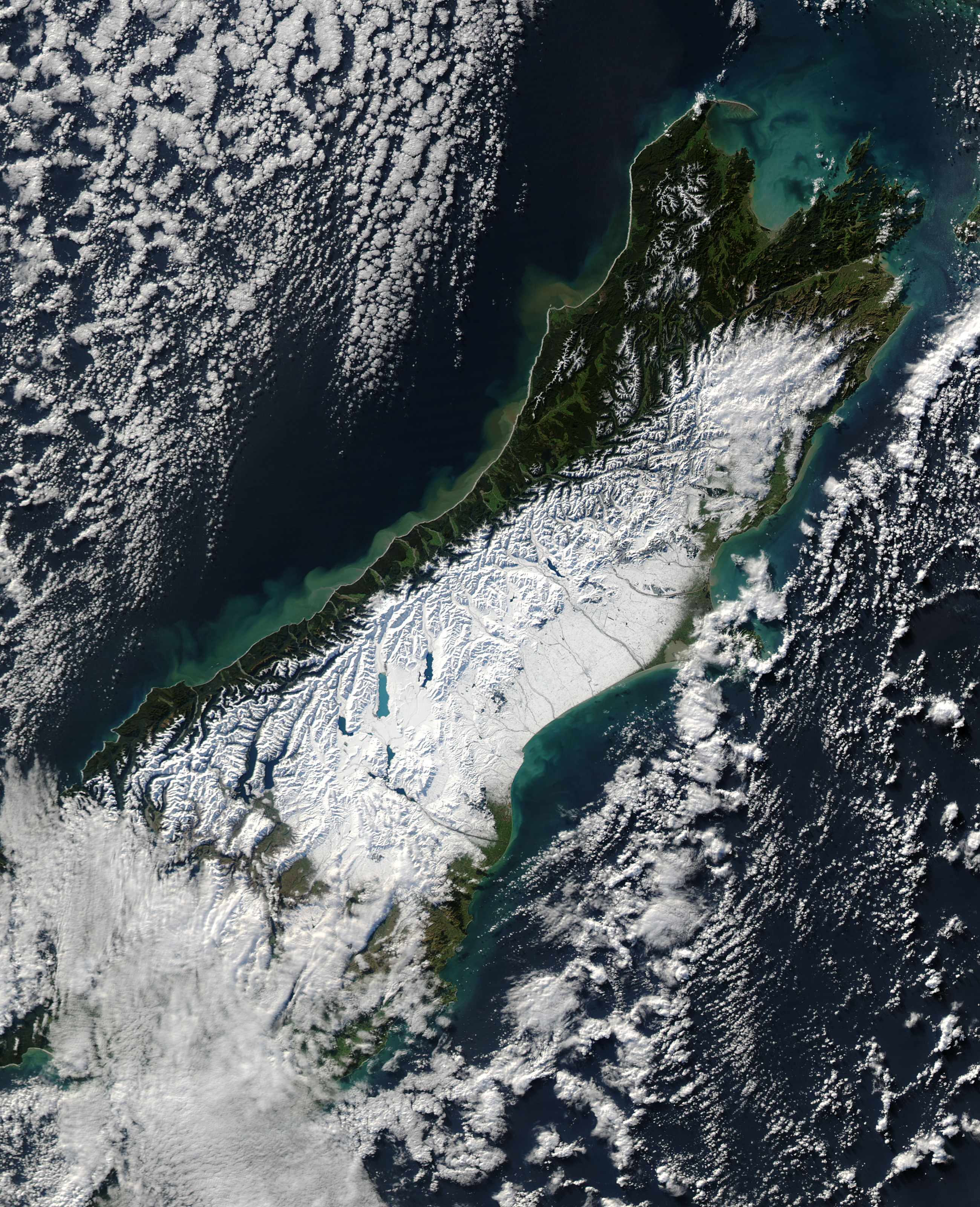
English: Satellite image of the South Island of New Zealand in June 2006. NASA's description:
Français : Une puissante tempête de neige balayant la Nouvelle-Zélande le 12 juin 2006. Selon l’Australian Broadcasting Corporation, la tempête amena de fortes rafales de vent atteignant 130 km/h et au moins une tornade. De fortes pluies provoquèrent des inondations et des glissements de terrain le long de la côte occidentale de l'île du Sud, la neige recouvrant la partie centrale de l'île.
Le 13 juin, lorsque l'imagerie produite par le spectromètre du satellite américain Aqua de la NASA, la neige recouvrait les Alpes du Sud, faisant ressortir les lacs des glaciers semblables à des doigts comme des saphirs sur un fond blanc. La neige atteint la mer du côté orientale de l'île. C'est ici, dans les bassins versants et les vallées à l'est des montagnes et autour de Christchurch, que la neige épaisse barra les routes et isola des communautés. Cette image montre également l'impacte des fortes précipitations le long de la côte occidentale de l'île du Sud. L'eau pleine de boue, chargée de sédiment provenant des glissements de terrain et des inondations, se déverse dans la mer de Tasmanie depuis les nombreux torrents qui s'écoulent des montagnes. |
|||||
| Ngày | ||||||
| Nguồn gốc | [1] | |||||
| Tác giả | NASA | |||||
| Giấy phép (Dùng lại tập tin) |
|

Lịch sử tập tin
Nhấn vào ngày/giờ để xem nội dung tập tin tại thời điểm đó.
| Ngày/giờ | Hình xem trước | Kích cỡ | Thành viên | Miêu tả | |
|---|---|---|---|---|---|
| hiện tại | 11:47, ngày 20 tháng 6 năm 2006 | | 2.600×3.200 (2,08 MB) | Brian | {{PD-USGov-NASA}} Satellite image of the w:South Island of w:New Zealand in June 2005. NASA's description: :A powerful winter storm swept across New Zealand on June 12, 2006. The storm brought strong winds that gusted up to 130 kilometers per h |
Trang sử dụng tập tin
Có 1 trang tại Wikipedia tiếng Việt có liên kết đến tập tin (không hiển thị trang ở các dự án khác):
Sử dụng tập tin toàn cục
Những wiki sau đang sử dụng tập tin này:
- Trang sử dụng tại af.wikipedia.org
- Trang sử dụng tại en.wikipedia.org
- Trang sử dụng tại es.wikipedia.org
- Trang sử dụng tại fr.wikipedia.org
- Trang sử dụng tại ru.wikipedia.org
- Trang sử dụng tại sl.wikipedia.org