Tập tin:Senyavin island (FSM).jpg

Không có độ phân giải cao hơn.
Senyavin_island_(FSM).jpg (457×265 điểm ảnh, kích thước tập tin: 102 kB, kiểu MIME: image/jpeg)
Tập tin này từ Wikimedia Commons. Trang miêu tả nó ở đấy được sao chép dưới đây. Commons là kho lưu trữ tập tin phương tiện có giấy phép tự do. Bạn có thể tham gia. |
.jpg?uselang=vi)
Miêu tả
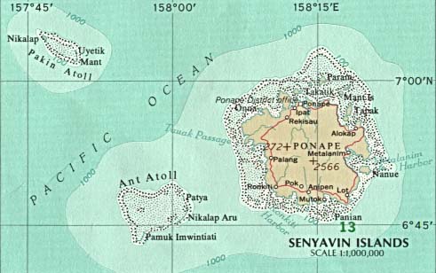
| Miêu tả | Map of Pohnpei (FSM - Micronesia) |
| Nguồn gốc |
|
| Tác giả |
Giấy phép
This map was obtained from an edition of the National Atlas of the United States. Like almost all works of the U.S. federal government, works from the National Atlas are in the public domain in the United States.
Online access: NationalAtlas.gov | 1970 print edition: Library of Congress, Perry-Castañeda Library
|
Nhật trình tải lên đầu tiên
(All user names refer to en.wikipedia)
- 2003-08-12 21:46 Pascal 457×265×8 (104132 bytes) Map of Pohnpei (FSM - Micronesia) from http://www.lib.utexas.edu/maps/australia/senyavin_island.jpg
Lịch sử tập tin
Nhấn vào ngày/giờ để xem nội dung tập tin tại thời điểm đó.
| Ngày/giờ | Hình xem trước | Kích cỡ | Thành viên | Miêu tả | |
|---|---|---|---|---|---|
| hiện tại | 20:51, ngày 7 tháng 3 năm 2007 | | 457×265 (102 kB) | Nicke L | {{Information |Description=Map of Pohnpei (FSM - Micronesia) |Source= *from http://www.lib.utexas.edu/maps/australia/senyavin_island.jpg *Originally from [http://en.wikipedia.org en.wikipedia]; description page is/was [http://en.wikipedia.org/w/index.php |
Trang sử dụng tập tin
Có 1 trang tại Wikipedia tiếng Việt có liên kết đến tập tin (không hiển thị trang ở các dự án khác):
Sử dụng tập tin toàn cục
Những wiki sau đang sử dụng tập tin này:
- Trang sử dụng tại ca.wikipedia.org
- Trang sử dụng tại ceb.wikipedia.org
- Trang sử dụng tại de.wikipedia.org
- Trang sử dụng tại en.wikipedia.org
- Trang sử dụng tại eo.wikipedia.org
- Trang sử dụng tại es.wikipedia.org
- Trang sử dụng tại fa.wikipedia.org
- Trang sử dụng tại fr.wikipedia.org
- Trang sử dụng tại gl.wikipedia.org
- Trang sử dụng tại it.wikipedia.org
- Trang sử dụng tại ja.wikipedia.org
- Trang sử dụng tại ka.wikipedia.org
- Trang sử dụng tại lt.wikipedia.org
- Trang sử dụng tại lv.wikipedia.org
- Trang sử dụng tại mk.wikipedia.org
- Trang sử dụng tại nl.wikipedia.org
- Trang sử dụng tại no.wikipedia.org
- Trang sử dụng tại pl.wikipedia.org
- Trang sử dụng tại pt.wikipedia.org
- Trang sử dụng tại ru.wikipedia.org
- Trang sử dụng tại tl.wikipedia.org
- Trang sử dụng tại uk.wikipedia.org
- Trang sử dụng tại www.wikidata.org
- Trang sử dụng tại zh-min-nan.wikipedia.org
- Trang sử dụng tại zh.wikipedia.org
.jpg)