Tập tin:Spitsbergen labelled.png
Không có độ phân giải cao hơn.
Spitsbergen_labelled.png (451×446 điểm ảnh, kích thước tập tin: 161 kB, kiểu MIME: image/png)
Tập tin này từ Wikimedia Commons. Trang miêu tả nó ở đấy được sao chép dưới đây. Commons là kho lưu trữ tập tin phương tiện có giấy phép tự do. Bạn có thể tham gia. |
Miêu tả
| Miêu tả |
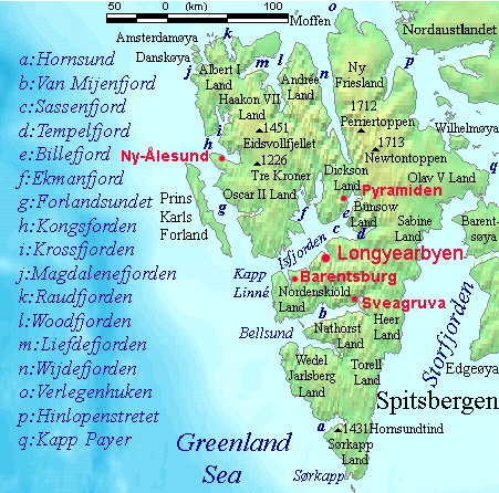
English: Map detailing the marine features of Spitsbergen in the Svalbard archipelago. Settlements and mountains are indicated and labelled. See also Image:Spitsbergen mountains and marine features labelled.png. Locations were labelled mainly based on detailed maps from svalbard-images.com (sample of south Spitsbergen linked), cross-referenced with other map sources where possible. Norwegian Polar Institute figures were used for mountain names and heights, which are given in meters above sea level. |
| Ngày | 25 tháng 7 năm 2006 (ngày tải lên ban đầu) |
| Nguồn gốc | No machine-readable source provided. Own work assumed (based on copyright claims). |
| Tác giả | No machine-readable author provided. TheGrappler assumed (based on copyright claims). |
Giấy phép
DEMIS World Map Server archive copy at the Wayback Machine generated this map from Public Domain sources. DEMIS does not claim any rights over the resultant image ([1] archive copy at the Wayback Machine). Alterations, including the addition of settlements and captions, were performed on 24 July 2006 by User:TheGrappler, the uploader, who releases all associated rights.
| Tôi, người giữ bản quyền của tác phẩm này, chuyển tác phẩm này vào phạm vi công cộng. Điều này có giá trị trên toàn thế giới. Tại một quốc gia mà luật pháp không cho phép điều này, thì: Tôi cho phép tất cả mọi người được quyền sử dụng tác phẩm này với bất cứ mục đích nào, không kèm theo bất kỳ điều kiện nào, trừ phi luật pháp yêu cầu những điều kiện đó. |
This image is in the public domain because it came from the site https://www.demis.nl/products/web-map-server/examples/ and was released by the copyright holder. Permission is granted to copy, distribute and/or modify this map since it is based on free of copyright images from: www.demis.nl. See also approval email on de.wp and its clarification.
|
| This work has been released into the public domain by its copyright holder, www.demis.nl. This applies worldwide. Tại một quốc gia mà luật pháp không cho phép điều này, thì: www.demis.nl cho phép tất cả mọi người được quyền sử dụng tác phẩm này với bất cứ mục đích nào, không kèm theo bất kỳ điều kiện nào, trừ phi luật pháp yêu cầu những điều kiện đó.
|
Lịch sử tập tin
Nhấn vào ngày/giờ để xem nội dung tập tin tại thời điểm đó.
| Ngày/giờ | Hình xem trước | Kích cỡ | Thành viên | Miêu tả | |
|---|---|---|---|---|---|
| hiện tại | 09:23, ngày 26 tháng 7 năm 2006 | | 451×446 (161 kB) | TheGrappler | More detail in South |
| 00:58, ngày 25 tháng 7 năm 2006 |  | 451×446 (159 kB) | TheGrappler | Move "Albert I Land" label slightly, to avoid obscuring Magdalenefjorden | |
| 00:46, ngày 25 tháng 7 năm 2006 |  | 451×446 (160 kB) | TheGrappler | == Summary == {{English}} Map detailing the marine features of Spitsbergen in the Svalbard archipelago. Settlements and mountains are indicated and labelled. See also Image:Spitsbergen mountains and marine features labelled.png. Locations were labell |
Trang sử dụng tập tin
Có 2 trang tại Wikipedia tiếng Việt có liên kết đến tập tin (không hiển thị trang ở các dự án khác):
Sử dụng tập tin toàn cục
Những wiki sau đang sử dụng tập tin này:
- Trang sử dụng tại af.wikipedia.org
- Trang sử dụng tại ast.wikipedia.org
- Trang sử dụng tại az.wikipedia.org
- Trang sử dụng tại bg.wikipedia.org
- Trang sử dụng tại ca.wikipedia.org
- Trang sử dụng tại ceb.wikipedia.org
- Trang sử dụng tại cv.wikipedia.org
- Trang sử dụng tại da.wikipedia.org
- Trang sử dụng tại de.wikipedia.org
- Trang sử dụng tại el.wikipedia.org
- Trang sử dụng tại en.wikipedia.org
- Spitsbergen
- Danes Island
- Isfjorden (Svalbard)
- Wijdefjorden
- Van Mijenfjorden
- Olav V Land
- Fairhaven (Svalbard)
- Bellsund
- Magdalenefjorden
- Recherche Fjord
- Forlandsundet
- Engelskbukta
- Amsterdam Island (Spitsbergen)
- Van Muydenbukta
- Van Keulenfjorden
- Krossfjorden
- Billefjorden
- Adventfjorden
- Grønfjorden
- Ekmanfjorden
- Moffen
Xem thêm các trang toàn cục sử dụng tập tin này.