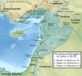
Tập tin:Syria under the Seleucids 95 BC.svg

Tập tin gốc(tập tin SVG, 1.014×944 điểm ảnh trên danh nghĩa, kích thước: 2,6 MB)

Miêu tả

Miêu tả
English: Following the defeath of Antiochus VII (died 129 BC) against Pathia, Syria contracted to the west of the Euphrates.[1] Parthia established the river as its western border and included Osroene.[2] To the north, the kingdom of Commagene bordered the Euphrates in the East, Cappadocia in the north (and included Melitene (Malatya) in its borders), the Amanus range in the west and Syria in the south (where Zeugma was the first Syrian city).[3] In the west, Cilicia between the Calycadnus river (Göksu) and the Orontes valley was under the rule of the Seleucids;[4][5] the Romans established a province of Cilicia in 102 BC but it did not include areas geographically in the region and the city of Side was the eastern point of that province.[6] In the south, Galilee fell to Judae except for the coastal city Ptolemais (Acre);[7][8] the latter remained part of Syria until the end of the Seleucid dynasty in 64 BC,[9] and it was the base for Antiochus X's widow Cleopatra Selene,[10] who was probably a resident of the city when her husband died.[11] Eastern Jordan was shared between the Nabateans and Judae whose king Alexander Jannaeus conquered Gadara in 100 BC.[12][13]
Ngày
Nguồn gốc SVG version of Attar-Aram syria's Syria under the Seleucids 95 BC.jpg
Tác giả Constantine Plakidas

Giấy phép

Tôi, người giữ bản quyền tác phẩm này, từ đây phát hành nó theo giấy phép sau:
w:vi:Creative Commons
ghi công chia sẻ tương tự
Tập tin này được phát hành theo Giấy phép Creative Commons Ghi công–Chia sẻ tương tự 4.0 Quốc tế.
Bạn được phép:
  • chia sẻ – sao chép, phân phối và chuyển giao tác phẩm
  • pha trộn – để chuyển thể tác phẩm
Theo các điều kiện sau:
  • ghi công – Bạn phải ghi lại tác giả và nguồn, liên kết đến giấy phép, và các thay đổi đã được thực hiện, nếu có. Bạn có thể làm các điều trên bằng bất kỳ cách hợp lý nào, miễn sao không ám chỉ rằng người cho giấy phép ủng hộ bạn hay việc sử dụng của bạn.
  • chia sẻ tương tự – Nếu bạn biến tấu, biến đổi, hoặc làm tác phẩm khác dựa trên tác phẩm này, bạn chỉ được phép phân phối tác phẩm mới theo giấy phép y hệt hoặc tương thích với tác phẩm gốc.
  1. Hogg, Hope W. (1911) "Mesopotamia" in The Encyclopedia Britannica: A Dictionary of Arts, Sciences, Literature and General Information, 18 (thứ 11 ed.), New York. Encyclopædia Britannica, Inc. 342 Madison Avenue, p. 184 OCLC: 1303014.
  2. Kia, Mehrdad (2016) The Persian Empire. A Historical Encyclopedia, Empires of the World, 1, ABC-CLIO, p. 55 ISBN: 978-1-61069-390-5.
  3. Goell, Theresa (1996) "Ancient Sources and Previous Scholarship" in Sanders, Donald H. , ed. Nemrud Dagi. The Hierothesion of Antiochus I of Commagene - Results of the American Excavations, 1: Texts, Eisenbrauns, p. 22 ISBN: 978-1-57506-015-6.
  4. (1988). "A Hoard of Aegean Tetradrachms and the Autonomous Tetradrachms of Elaeusa Sebast". Museum Notes 33: 85. The American Numismatic Society. ISSN 0145-1413.
  5. (2009). "Seleucid Campaign Beards". L'Antiquité Classique 78. l’asbl L’Antiquité Classique. ISSN 0770-2817.
  6. (2011). "The Route Taken by Cilicia to Provincial Status: When and Why?". Olba: The Journal of Research Center for Cilician Archaeology 19: 268, 273. Mersin University Publicattions of the Research Center of Cilician Archaeology [KAAM]. ISSN 7667 1301 7667.
  7. Chancey, Mark A. (2002) The Myth of a Gentile Galilee, Society for New Testament Studies Monograph Series, 118, Cambridge University Press, p. 45 ISBN: 978-0-511-48792-7.
  8. Smallwood, E. Mary (1976) The Jews Under Roman Rule: From Pompey to Diocletian, Brill, p. 15 ISBN: 978-90-04-04491-3.
  9. Goldmann, Zeev (1975) [1970] "Accho" , 1, Prentice-Hall, p. 15 ISBN: 978-0-132-75115-5.
  10. Kadman, Leo (1961) The Coins of Akko Ptolemais, Corpus nummorum Palaestinensium, IV, Schocken Publishing House, p. 21 OCLC: 716861188.
  11. Whitehorne, John (1994) Cleopatras, Routledge, p. 169 ISBN: 978-0-415-05806-3.
  12. Rababeh, Shaher Moh'd Ahmad (2006) How Petra was Built: an Analysis of the Construction Techniques of the Nabataean Freestanding Buildings and Rock-Cut Monuments in Petra, Jordan, British Archaeological Reports International Series, 1460, BAR Publishing, p. 10 ISBN: 978-1-841-71898-9.
  13. "Gadara (Irbid, Jordan)" in (1996) International Dictionary of Historic Places, 4 (Middle East and Africe), Fitzroy Dearborn Publishers, p. 284 ISBN: 978-1-884964-03-9.

Chú thích

Ghi một dòng giải thích những gì có trong tập tin này

Khoản mục được tả trong tập tin này

mô tả

Lịch sử tập tin

Nhấn vào ngày/giờ để xem nội dung tập tin tại thời điểm đó.

Ngày/giờHình xem trướcKích cỡThành viênMiêu tả
hiện tại16:42, ngày 30 tháng 6 năm 2018Hình xem trước của phiên bản lúc 16:42, ngày 30 tháng 6 năm 20181.014×944 (2,6 MB)Cplakidasfixing things missed from original map: correcting border at Gadara; adding Galilee as a region, changing Judea to font denoting a state; adding Nisibis
16:35, ngày 30 tháng 6 năm 2018Hình xem trước của phiên bản lúc 16:35, ngày 30 tháng 6 năm 20181.014×944 (2,59 MB)CplakidasUser created page with UploadWizard
Có 1 trang tại Wikipedia tiếng Việt có liên kết đến tập tin (không hiển thị trang ở các dự án khác):

Sử dụng tập tin toàn cục

Những wiki sau đang sử dụng tập tin này:

Đặc tính hình