Tập tin:Thames Estuary and Wind Farms from Space NASA with annotations.jpg

Kích thước hình xem trước: 750×600 điểm ảnh. Độ phân giải khác: 300×240 điểm ảnh | 600×480 điểm ảnh | 960×768 điểm ảnh | 1.280×1.024 điểm ảnh | 2.560×2.048 điểm ảnh | 5.000×4.000 điểm ảnh.
Tập tin gốc (5.000×4.000 điểm ảnh, kích thước tập tin: 3,74 MB, kiểu MIME: image/jpeg)
Tập tin này từ Wikimedia Commons. Trang miêu tả nó ở đấy được sao chép dưới đây. Commons là kho lưu trữ tập tin phương tiện có giấy phép tự do. Bạn có thể tham gia. |
Miêu tả
| Miêu tả |
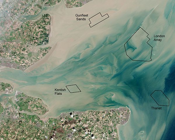
English: Thames Estuary and Wind Farms from Space NASA. Windfarms visible in the image are: London Array, Thanet Wind Farm, Kentish Flats Wind Farm and Gunfleet Sands Wind Farm. Kentish Flats is pictured before its 2015 extension was constructed. |
| Ngày | |
| Nguồn gốc | Annotated version of File:Thames Estuary and Wind Farms from Space NASA.jpg showing offshore wind farms |
| Tác giả | Operational Land Imager, with annotations by Delusion23 |
| Phiên bản khác |
 (no annotations) |
| Vị trí máy chụp hình | | Xem hình này và các hình ảnh lân cận trên: OpenStreetMap |
|---|
Giấy phép
| This file is in the public domain in the United States because it was solely created by NASA. NASA copyright policy states that "NASA material is not protected by copyright unless noted". (See Template:PD-USGov, NASA copyright policy page or JPL Image Use Policy.) | ||
 |
Warnings:
|
| Annotations | This image is annotated: View the annotations at Commons |
Lịch sử tập tin
Nhấn vào ngày/giờ để xem nội dung tập tin tại thời điểm đó.
| Ngày/giờ | Hình xem trước | Kích cỡ | Thành viên | Miêu tả | |
|---|---|---|---|---|---|
| hiện tại | 21:23, ngày 22 tháng 6 năm 2015 | | 5.000×4.000 (3,74 MB) | Delusion23 | User created page with UploadWizard |
Trang sử dụng tập tin
Có 1 trang tại Wikipedia tiếng Việt có liên kết đến tập tin (không hiển thị trang ở các dự án khác):
Sử dụng tập tin toàn cục
Những wiki sau đang sử dụng tập tin này:
- Trang sử dụng tại en.wikipedia.org
- Trang sử dụng tại fr.wikipedia.org
- Trang sử dụng tại ig.wikipedia.org
- Trang sử dụng tại it.wikipedia.org
- Trang sử dụng tại ja.wikipedia.org
- Trang sử dụng tại nl.wikipedia.org
- Trang sử dụng tại ru.wikipedia.org
- Trang sử dụng tại sv.wikipedia.org
- Trang sử dụng tại zh.wikipedia.org