Tập tin:Top of Atmosphere.jpg
Tập tin gốc (3.027×2.010 điểm ảnh, kích thước tập tin: 543 kB, kiểu MIME: image/jpeg)
Tập tin này từ Wikimedia Commons. Trang miêu tả nó ở đấy được sao chép dưới đây. Commons là kho lưu trữ tập tin phương tiện có giấy phép tự do. Bạn có thể tham gia. |
| Đây là một hình ảnh đã được chọn làm hình ảnh chọn lọc và được giới thiệu trên Trang Chính của Wikipedia tiếng Việt. |
|
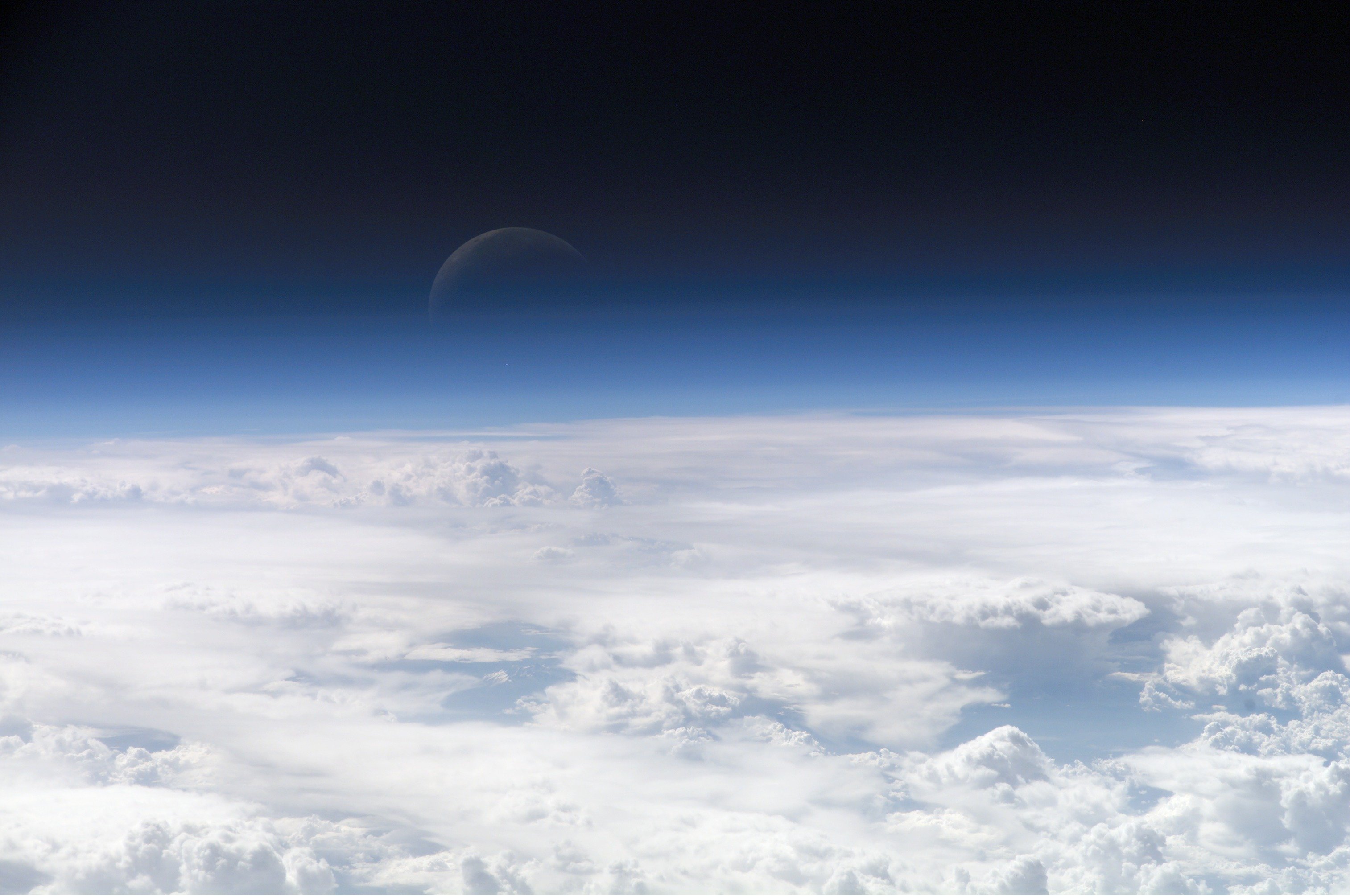
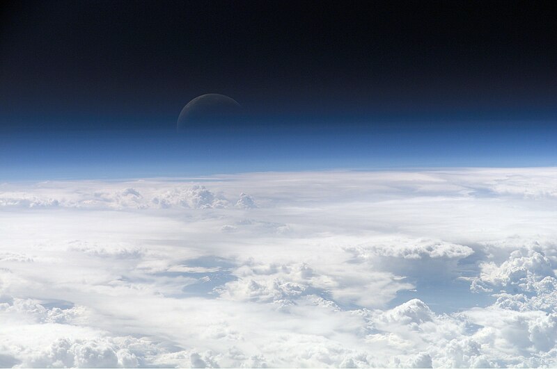
Bức hình này đã được chọn làm hình ảnh của ngày trên Wikimedia Commons vào ngày 22 tháng 2 năm 2013. Dưới đây là lời mô tả: English: View of the crescent moon through the top of the earth's atmosphere. Photographed from International Space Station by Expedition 13 crew over the South China Sea, just south of Macau. Các ngôn ngữ khác:
Čeština: Pohled na srpek Měsíce skrz vršek zemské atmosféry. Vyfoceno posádkou Mezinárodní vesmírné stanice v rámci Expedice 13 nad Jihočínským mořem jižně od Macaa, 21,5° S, 113,3° V Deutsch: Die oberen Schichten der Erdatmosphäre, gesehen von der Internationalen Raumstation (ISS) während der ISS-Expedition 13 English: View of the crescent moon through the top of the earth's atmosphere. Photographed from International Space Station by Expedition 13 crew over the South China Sea, just south of Macau. Italiano: Vista della luna crescente dalla sommità dell'atmosfera terrestre. Foto scattata alle coordinate 21.5°N, 113.3°E dall'equipaggio della Stazione Spaziale Orbitante Internazionale Expedition 13 sopra il Mar Cinese Orientale, appena a sud di Macau (NASA image ID: ISS013-E-54329). Magyar: Félholdra táruló kilátás a Föld légkörén keresztül. A fénykép a Nemzetközi Űrállomás 13-dik expedícióján, a Dél-kínai-tenger fölött, Makaótól délre készült. Nederlands: Zicht op de maansikkel door de bovenkant van de atmosfeer van de aarde. Gefotografeerd boven 21,5° N, 113,3° E door de bemanning van het internationaal ruimtestation ISS tijdens expeditie 13 boven de Zuid-Chinese Zee, net ten zuiden van Macau. Polski: Widok Księżyca z górnych warstw amosfery ziemskiej. Fotografia wykonana przez załogę Ekspedycji 13 Międzynarodowej Stacji Kosmicznej nad Morzem Południowochińskim, na południe od Makau Svenska: En månskära sedd genom atmosfärens övre lager, fotograferad från Internationella rymdstationen ovanför Sydkinesiska sjön söder om Macau. ქართული: სამხრეთი ჩინეთის ზღვის თავზე, მაკაოს სამხრეთით, მე-13 ექსპედიციის მონაწილის მიერ გადაღებული ნახევარმთვარის ფოტო დედამიწის ატმოსფეროს ზედა ფენებიდან. 中文: 地球大气层上的新月,地理位置为中国南海上空,经纬度21.5°N, 113.3°E,由国际空间站第13远征组成员拍摄。 |
Miêu tả
| Miêu tả |
Čeština: Pohled na srpek Měsíce skrz vršek zemské atmosféry. Vyfoceno posádkou Mezinárodní vesmírné stanice v rámci Expedice 13 nad Jihočínským mořem jižně od Macaa, 21,5° S, 113,3° V
English: View of the crescent moon through the top of the Earth's atmosphere. Photographed above 21.5°N, 113.3°E by International Space Station crew Expedition 13 over the South China Sea, just south of Macau (NASA image ID: ISS013-E-54329).
Français : Photo des couches hautes de l'atmosphère terrestre, prise par 21.5°N, 113.3°E par la Station spatiale internationale au cours de l'Expédition 13 au-dessus de la Mer de Chine méridionale, juste au sud de Macao. Numéro d'identification d'image de la NASA : ISS013-E-54329.
Italiano: Vista della luna crescente dalla sommità dell'atmosfera terrestre. Foto scattata alle coordinate 21.5°N, 113.3°E dall'equipaggio della Stazione Spaziale Internazionale Expedition 13 sopra il Mar Cinese Orientale, appena a sud di Macau (NASA image ID: ISS013-E-54329).
ქართული: სამხრეთი ჩინეთის ზღვის თავზე, მაკაოს სამხრეთით, მე-13 ექსპედიციის მონაწილის მიერ გადაღებული ნახევარმთვარის ფოტო დედამიწის ატმოსფეროს ზედა ფენებიდან.
Polski: Zdjęcie górnych warstw atmosfery ziemskiej z widocznym przejściem w przestrzeń kosmiczną.
Ελληνικά: Η Γήινη ατμόσφαιρα, η φωτογραφία ελήφθη από το διάστημα κι ύψος 335 χιλιόμετρα |
| Ngày | |
| Nguồn gốc | http://eol.jsc.nasa.gov/scripts/sseop/photo.pl?mission=ISS013&roll=E&frame=54329 |
| Tác giả | NASA Earth Observatory |
This image or video was catalogued by one of the centers of the United States National Aeronautics and Space Administration (NASA) under Photo ID: ISS013-E-54329. This tag does not indicate the copyright status of the attached work. A normal copyright tag is still required. See Commons:Licensing. Other languages:
|
Giấy phép
| This file is in the public domain in the United States because it was solely created by NASA. NASA copyright policy states that "NASA material is not protected by copyright unless noted". (See Template:PD-USGov, NASA copyright policy page or JPL Image Use Policy.) | ||
 |
Warnings:
|
Image information
Identification
Top Of The Atmosphere
Mission: ISS013 Roll: E Frame: 54329 Mission ID on the Film or image: ISS013
Country or Geographic Name:
Features: EARTH LIMB, MOON, CLOUD TOPS
Center Point Latitude: Center Point Longitude: (Negative numbers indicate south for latitude and west for longitude)
Stereo: (Yes indicates there is an adjacent picture of the same area)
ONC Map ID: JNC Map ID:
'MORALES'
Camera Tilt: Low Oblique
Camera Focal Length: 400mm
Camera: E4: Kodak DCS760C Electronic Still Camera
Film: 3060E : 3060 x 2036 pixel CCD, RGBG array.
Quality
Film Exposure:
Percentage of Cloud Cover: 100 (76-100)
Nadir
Date: 20060720 (YYYYMMDD)GMT Time: 082858 (HHMMSS)
Nadir Point Latitude: 21.5, Longitude: 113.3 (Negative numbers indicate south for latitude and west for longitude)
Nadir to Photo Center Direction:
Sun Azimuth: 281 (Clockwise angle in degrees from north to the sun measured at the nadir point)
Spacecraft Altitude: 181 nautical miles (335 km)
Sun Elevation Angle: 35 (Angle in degrees between the horizon and the sun, measured at the nadir point)
Orbit Number: 3839
Lịch sử tập tin
Nhấn vào ngày/giờ để xem nội dung tập tin tại thời điểm đó.
| Ngày/giờ | Hình xem trước | Kích cỡ | Thành viên | Miêu tả | |
|---|---|---|---|---|---|
| hiện tại | 08:09, ngày 27 tháng 2 năm 2007 | | 3.027×2.010 (543 kB) | SirGrant | {{Information |Description= Image of the top layers of the earth's atmosphere leading to space |Source= [http://eobadmin.gsfc.nasa.gov/Newsroom/NewImages/images.php3?img_id=17542] direct link:[http://eobadmin.gsfc.nasa.gov/Newsroom/NewImages/Images/ISS01 |
Trang sử dụng tập tin
- Bầu khí quyển sao
- Callisto (vệ tinh)
- Enceladus (vệ tinh)
- Europa (vệ tinh)
- Ganymede (vệ tinh)
- HD 209458 b
- Hàng không vũ trụ
- Hành tinh
- Khí quyển
- Khí quyển Mặt Trăng
- Khí quyển Sao Hỏa
- Khí quyển Sao Kim
- Khí quyển Sao Mộc
- Khí quyển Sao Thiên Vương
- Khí quyển Sao Thủy
- Khí quyển Titan
- Khí quyển Triton
- Khí quyển Trái Đất
- Môi trường tự nhiên
- Tự nhiên
- Đường Kármán
- Đầu sao chổi
- Thành viên:Minh Tấn/Hình ảnh/T
- Wikipedia:Hình ảnh chọn lọc/2013/07
- Wikipedia:Hình ảnh chọn lọc/2013/07/25
- Bản mẫu:Khí quyển
- Cổng thông tin:Thiên nhiên/Bài viết/Lưu trữ/1
Sử dụng tập tin toàn cục
Những wiki sau đang sử dụng tập tin này:
- Trang sử dụng tại af.wikipedia.org
- Trang sử dụng tại als.wikipedia.org
- Trang sử dụng tại ami.wikipedia.org
- Trang sử dụng tại am.wikipedia.org
- Trang sử dụng tại anp.wikipedia.org
- Trang sử dụng tại an.wikipedia.org
- Trang sử dụng tại ar.wikipedia.org
- كوكب
- زحل
- غلاف جوي
- غلاف الأرض الجوي
- علوم الأرض
- العصر الجديد
- بوابة:علوم/صورة مختارة
- إنسيلادوس
- غلاف المشتري الجوي
- علوم الغلاف الجوي
- سبيس شيب تو
- قالب:أغلفة جوية
- ويكيبيديا:أسبوع الويكي/فلك/مقالات ضمن قوالب
- خط كارمان
- غلاف الزهرة الجوي
- بيئة قاسية
- فضاء جوي
- ذؤابة
- بوابة:علوم الأرض
- بوابة:علوم الأرض/صورة مختارة
- بوابة:علوم الأرض/مقالات متعلقة
- بوابة:علوم الأرض/صورة مختارة/3
- بوابة:علوم الأرض/صورة مختارة/أرشيف
- بوابة:علوم/صورة مختارة/1
- غلاف النجم الجوي
- الغلاف الجوي للقمر
- اكتشاف واستكشاف النظام الشمسي
- غلاف تيتان الجوي
- غلاف ترايتون الجوي
- مستخدم:Madleen Al-kanash
- غلاف جوي خارج الأرض
- مستخدم:ASammour/صور مختارة
- الغلاف الأرضي
- غلاف عطارد الجوي
- Trang sử dụng tại ary.wikipedia.org
- Trang sử dụng tại arz.wikipedia.org
- Trang sử dụng tại ast.wikipedia.org
- Trang sử dụng tại as.wikipedia.org
Xem thêm các trang toàn cục sử dụng tập tin này.