Tập tin:Venice Lagoon December 9 2001.jpg
Kích thước hình xem trước: 512×599 điểm ảnh. Độ phân giải khác: 205×240 điểm ảnh | 410×480 điểm ảnh | 656×768 điểm ảnh | 875×1.024 điểm ảnh | 1.750×2.048 điểm ảnh | 3.580×4.189 điểm ảnh.
Tập tin gốc (3.580×4.189 điểm ảnh, kích thước tập tin: 11,35 MB, kiểu MIME: image/jpeg)
Tập tin này từ Wikimedia Commons. Trang miêu tả nó ở đấy được sao chép dưới đây. Commons là kho lưu trữ tập tin phương tiện có giấy phép tự do. Bạn có thể tham gia. |
Miêu tả
| Miêu tả |
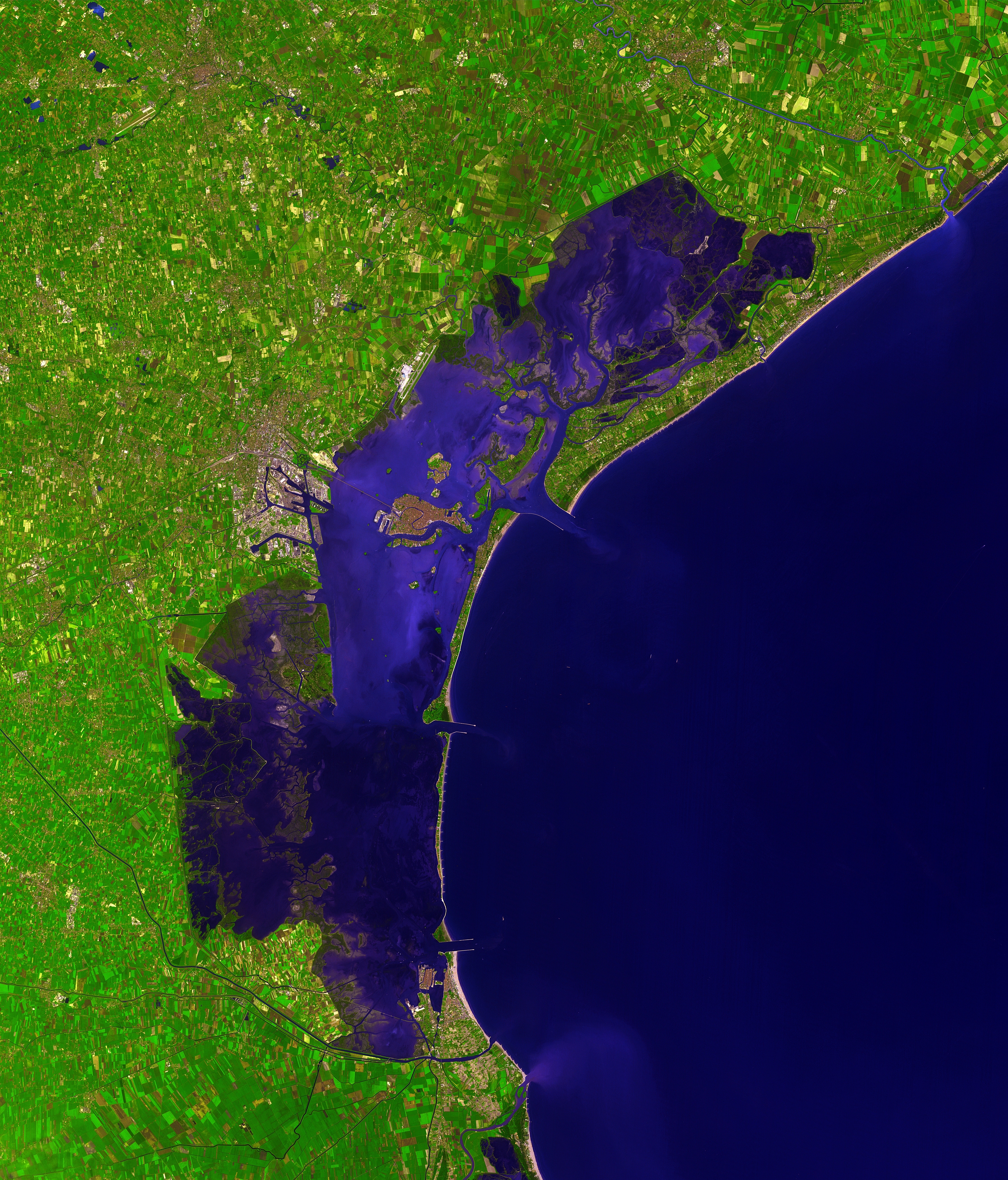
Deutsch: Dieses Satellitenbild der Lagune von Venedig wurde von ASTER (Advanced Spaceborne Thermal Emission and Reflection Radiometer) aufgenommen, einem Aufnahmesystem an Bord des Satelliten Terra der Teil des NASA Earth Observing System (EOS) ist. Das Bild wurde am 9. Dezember 2001 erstellt und deckt eine Fläche von 39 x 35 km ab. (Simulierte Naturfarben)
English: This picture of the Venetian Lagoon was taken by ASTER (Advanced Spaceborne Thermal Emission and Reflection Radiometer), an imaging instrument flying on Terra, a satellite part of NASA's Earth Observing System (EOS). It covers an area of 39 x 35 km and was acquired on December 9, 2001. (simulated natural color)
Français : Image de la lagune de Venise prise par l'instrument d'imagerie ASTER (Advanced Spaceborne Thermal Emission and Reflection Radiometer) embarqué sur le satellite Terra, lancé dans le cadre du programme EOS (Earth Observing System, ou Système d'Observation de la Terre). Aire couverte: 39 x 35 km, Couleurs naturelles simulées. Image prise le 9 décembre 2001.
Italiano: Questa immagine della Laguna di Venezia è stata ripresa da ASTER (Advanced Spaceborne Thermal Emission and Reflection Radiometer), uno strumento installato su Terra, un satellite della NASA Earth Observing System (EOS). Copre un'area di 39 x 35 km ed è stata ripresa il 9 dicembre 2001. (colori naturali simulati) |
| Ngày | |
| Nguồn gốc | http://earthobservatory.nasa.gov/Newsroom/NewImages/images.php3?img_id=16314 |
| Tác giả | NASA/GSFC/MITI/ERSDAC/JAROS, and U.S./Japan ASTER Science Team |
| Phiên bản khác |
 |
| Vị trí máy chụp hình | | Xem hình này và các hình ảnh lân cận trên: OpenStreetMap |
|---|
|

Bức hình này đã được chọn làm hình ảnh của ngày trên Wikimedia Commons vào ngày 15 tháng 9 năm 2007. Dưới đây là lời mô tả: English: Satellite photo of the Venetian Lagoon. Các ngôn ngữ khác:
Asturianu: Semeya satelital de la Llaguna de Venecia Deutsch: Satellitenbild der Lagune von Venedig English: Satellite photo of the Venetian Lagoon. Español: Fotografía de satélite de la laguna de Venecia. Euskara: Veneziako badia satelitetik ikusia Français : La lagune de Venise vue par satellite Íslenska: Gervihnattamynd af Feneyjalóni. Italiano: Foto satellitare della laguna di Venezia. Magyar: A velencei lagúna műholdas képe (39 x 35 km-es terület, szinezve, 2001. december 9.) Беларуская: Венецыянская лагуна, здымак з космасу. Русский: Венецианская лагуна, снимок из космоса |
Giấy phép
| This file is in the public domain in the United States because it was solely created by NASA. NASA copyright policy states that "NASA material is not protected by copyright unless noted". (See Template:PD-USGov, NASA copyright policy page or JPL Image Use Policy.) | ||
 |
Warnings:
|
| Annotations | This image is annotated: View the annotations at Commons |

Lịch sử tập tin
Nhấn vào ngày/giờ để xem nội dung tập tin tại thời điểm đó.
| Ngày/giờ | Hình xem trước | Kích cỡ | Thành viên | Miêu tả | |
|---|---|---|---|---|---|
| hiện tại | 15:41, ngày 7 tháng 12 năm 2006 | | 3.580×4.189 (11,35 MB) | AlMare | Cropped |
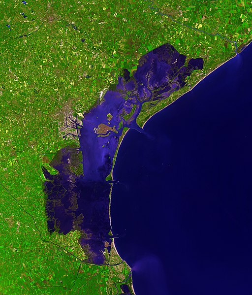
| 11:46, ngày 13 tháng 11 năm 2006 |  | 3.598×4.200 (11,09 MB) | AlMare | ||
| 14:14, ngày 10 tháng 11 năm 2006 |  | 3.598×4.200 (8,42 MB) | AlMare | {{en|This picture of the en:Venetian Lagoon was taken by ASTER (Advanced Spaceborne Thermal Emission and Reflection Radiometer), an imaging instrument flying on Terra, a satellite part of NASA's Earth Observing System |
Trang sử dụng tập tin
Có 2 trang tại Wikipedia tiếng Việt có liên kết đến tập tin (không hiển thị trang ở các dự án khác):
Sử dụng tập tin toàn cục
Những wiki sau đang sử dụng tập tin này:
- Trang sử dụng tại ar.wikipedia.org
- Trang sử dụng tại ast.wikipedia.org
- Trang sử dụng tại ba.wikipedia.org
- Trang sử dụng tại be.wikipedia.org
- Trang sử dụng tại bg.wikipedia.org
- Trang sử dụng tại bn.wikipedia.org
- Trang sử dụng tại bn.wikibooks.org
- Trang sử dụng tại br.wikipedia.org
- Trang sử dụng tại ca.wikipedia.org
- Trang sử dụng tại cs.wikipedia.org
- Trang sử dụng tại cy.wikipedia.org
- Trang sử dụng tại de.wikipedia.org
- Trang sử dụng tại de.wiktionary.org
- Trang sử dụng tại el.wikipedia.org
- Trang sử dụng tại en.wikipedia.org
- Trang sử dụng tại en.wiktionary.org
- Trang sử dụng tại eo.wikipedia.org
- Trang sử dụng tại eo.wikivoyage.org
- Trang sử dụng tại et.wikipedia.org
- Trang sử dụng tại fa.wikibooks.org
- Trang sử dụng tại fi.wikipedia.org
- Trang sử dụng tại fi.wiktionary.org
- Trang sử dụng tại frr.wikipedia.org
- Trang sử dụng tại fr.wikipedia.org
- Trang sử dụng tại fy.wikipedia.org
- Trang sử dụng tại gl.wikipedia.org
- Trang sử dụng tại hi.wikipedia.org
- Trang sử dụng tại hr.wikipedia.org
- Trang sử dụng tại hu.wikipedia.org
Xem thêm các trang toàn cục sử dụng tập tin này.